Manapōuri Power Station is an underground hydroelectric power station on the western arm of Lake Manapouri in Fiordland National Park, in the South Island of New Zealand. At 854 MW installed capacity, it is the largest hydroelectric power station in New Zealand, and the second largest power station in New Zealand. The station is noted for the controversy and environmental protests by the Save Manapouri Campaign against raising the level of Lake Manapouri to increase the station's hydraulic head, which galvanised New Zealanders and was one of the foundations of the New Zealand environmental movement.
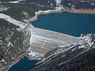
Mica Dam is a hydroelectric embankment dam spanning the Columbia River 135 kilometres north of Revelstoke, British Columbia, Canada. It was built as one of three Canadian projects under the terms of the 1964 Columbia River Treaty and is operated by BC Hydro. Completed in 1973, the Mica powerhouse had an original generating capacity of 1,805 megawatts (MW). Mica Dam, named after the nearby settlement of Mica Creek and its associated stream, in turn named after the abundance of mica minerals in the area, is one of the largest earthfill dams in the world. The reservoir created by the dam is Kinbasket Lake. Water from the dam flows south directly into Revelstoke Lake, the reservoir for the Revelstoke Dam. Mica Dam is the tallest dam in Canada and second tallest in North America after the Chicoasén Dam in Mexico and it is the farthest upstream dam on the Columbia River. The dam's underground powerhouse was the second largest in the world at the time of its construction, and was the first 500 kV installation of sulphur hexafluoride (SF6) insulated switchgear in the world.

An underground power station is a type of hydroelectric power station constructed by excavating the major components from rock, rather than the more common surface-based construction methods.

The Waipori River is in Otago in the South Island of New Zealand. Rising in the Lammerlaw Range, it flows southeast for 50 kilometres (31 mi) before joining the Taieri River near Henley, 30 kilometres (19 mi) southwest of Dunedin of which it is officially the southernmost border. Google Maps erroneously shows the stretch of Taieri river from the confluence to the mouth as Waipori River. The correct name is shown on the New Zealand government's official NZ Topo Map.

The Roxburgh Dam is the earliest of the large hydroelectric projects in the lower half of the South Island of New Zealand. It lies across the Clutha River / Mata-Au, some 160 kilometres (99 mi) from Dunedin, some 9 kilometres (5.6 mi) to the north of the town of Roxburgh. The settlement of Lake Roxburgh Village is close to the western edge of the dam.
Lake Margaret is a concrete-faced gravity dam with an uncontrolled spillway across the Yolande River, located on the north side of Mount Sedgwick, in the West Coast Range, West Coast of Tasmania, Australia.
The Shoalhaven Scheme is a dual-purpose water supply and Pumped-storage Hydroelectricity scheme located on the South Coast region of New South Wales, Australia.
Cochrane Dam is a minor earthfill embankment dam with concrete spillway across Georges Creek, located in the South Coast region of New South Wales, Australia. The main purpose of the dam is to supply water for hydro-power at the downstream Brown Mountain Power Station and for irrigation purposes. The impounded reservoir is called Cochrane Lake.
Chenderoh Power Station or Chenderoh Dam was the first major hydroelectric dam and power station in Malaysia. It was preceded by two stations on Malaya's rivers; the 800kw Ulu Gombak station in Selangor (1905) that was used to provide Kuala Lumpur's first electricity, and the Sungei Besi Tin Mines Ltd scheme at Ulu Langat that was purchased by FMS Electrical Department in 1929. The dam is located at Chenderoh Lake, Kuala Kangsar District, Perak. It was constructed by Perak River Hydro-Electric Power Company Ltd and completed in 1930. The scheme was designed by consulting engineers Rendel, Palmer & Tritton of London and Vattenbyggnadsbyran (VBB) of Stockholm, Sweden. The architect was Osvald Almqvist.
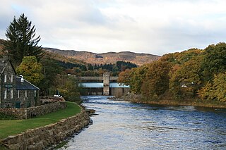
The Tummel hydro-electric power scheme is an interconnected network of dams, power stations, aqueducts and electric power transmission in the Grampian Mountains of Scotland. Roughly bounded by Dalwhinnie in the north, Rannoch Moor in the west and Pitlochry in the east it comprises a water catchment area of around 1,800 square kilometres and primary water storage at Loch Ericht, Loch Errochty, Loch Rannoch and Loch Tummel, in Perth and Kinross. Water, depending on where it originates and the path it takes, may pass through as many as five of the schemes nine power stations as it progresses from north-west to south-east. The scheme was constructed in the 1940s and 50s incorporating some earlier sites. It is managed by SSE plc.

The Monowai Power Station, fed by the Monowai River from Lake Monowai in Southland, New Zealand, was one of the earliest hydroelectric power stations in the country. Originally commissioned in 1925, it was refurbished between 2005 and 2007 and now contains modern turbines and plant, though the original buildings are still in use.

The Mahinerangi Wind Farm is a wind farm on the north side of Lake Mahinerangi, around 50 km west of Dunedin, in Otago, New Zealand. Stage one of the wind farm, generating 36 MW, was commissioned in March 2011, and an additional 160 MW is consented to be commissioned in further stages.

Hydroelectric power in New Zealand has been a part of the country's energy system for over 100 years and continues to provide more than half of the country's electricity needs. Hydroelectricity is the primary source of renewable energy in New Zealand. Power is generated the most in the South Island and is used most in the North Island.

The Coleridge Power Station is a hydroelectric facility at Lake Coleridge on the Rakaia River in Canterbury, New Zealand. The power station is owned and operated by Manawa Energy.

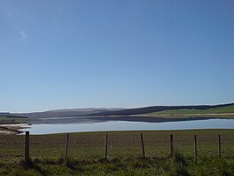
Lake Onslow is a man-made lake east of Roxburgh and south of Alexandra in the Otago region of New Zealand. It lies 700 m (2,300 ft) above sea level. It was formed in 1890 by the damming of the Teviot River and Dismal Swamp, with a new dam built in 1982 that raised the lake level by 5 m (16 ft). It is the site considered for a pumped-storage hydroelectricity project.

The Cobb Power Station is a hydroelectric facility on the Cobb River, in the Tasman District of New Zealand. The power station is located in Upper Tākaka, 112 km (70 mi) northwest of Nelson. Annual generation is approximately 190 gigawatt-hours (680 TJ). The initial stages of the construction of the station began as a privately-funded scheme in 1935, but the investor failed to raise the necessary capital. The national government took over building the station and the first power was produced in 1944, operating as a run-of-river station. A storage dam was completed in 1954. The resulting hydro lake is the highest in the country and at 596 m (1,955 ft), the station has New Zealand's highest hydraulic head of any power station.
Whakamaru Power Station is a hydroelectric power station on the Waikato River, in the North Island of New Zealand. It is the fourth hydroelectric power station on the Waikato River.

The Cobb Reservoir is a hydro storage lake fed by the Cobb River in the Tasman District of the South Island of New Zealand. The reservoir feeds the Cobb Power Station and is 819 metres (2,687 ft) above sea level but drops significantly with low rainfall. Cobb Reservoir is the highest hydro storage lake in New Zealand, and is entirely surrounded by Kahurangi National Park. The reservoir, dam, penstock and powerhouse are excluded from the national park.
The Kuratau power station is a hydroelectric power facility in Kuratau on the western side of Lake Taupō in New Zealand which makes use of water from the Kuratau River. The river is impounded behind a dam to form Lake Kuratau before discharging through the power station back into the river. The scheme is operated by Trustpower on behalf of its owner King Country Energy.