Lauder, New Zealand

Last updated
New Zealand location map.svg
Disc Plain red.svg
Lauder

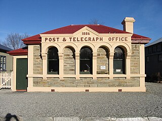
Lauder is a small settlement in the Otago Region of the South Island of New Zealand. It is located in Central Otago, 8 km northeast of Omakau, on the main route between Alexandra and Ranfurly, State Highway 85. The settlement was named after the town of the same name in southern Scotland, [1] one of many Otago sites to be named after places in the Scottish borders by John Turnbull Thomson. [2]

Otago Region of New Zealand in South Island

Otago is a region of New Zealand in the south of the South Island administered by the Otago Regional Council. It has an area of approximately 32,000 square kilometres (12,000 sq mi), making it the country's third largest local government region. Its population was 229,200 in June 2018.

South Island Southernmost of the two main islands in New Zealand

The South Island, also officially named Te Waipounamu, is the larger of the two major islands of New Zealand in surface area; the other being the smaller but more populous North Island. It is bordered to the north by Cook Strait, to the west by the Tasman Sea, and to the south and east by the Pacific Ocean. The South Island covers 150,437 square kilometres (58,084 sq mi), making it the world's 12th-largest island. It has a temperate climate.

New Zealand Country in Oceania

New Zealand is a sovereign island country in the southwestern Pacific Ocean. The country geographically comprises two main landmasses—the North Island, and the South Island —and around 600 smaller islands. New Zealand is situated some 2,000 kilometres (1,200 mi) east of Australia across the Tasman Sea and roughly 1,000 kilometres (600 mi) south of the Pacific island areas of New Caledonia, Fiji, and Tonga. Because of its remoteness, it was one of the last lands to be settled by humans. During its long period of isolation, New Zealand developed a distinct biodiversity of animal, fungal, and plant life. The country's varied topography and its sharp mountain peaks, such as the Southern Alps, owe much to the tectonic uplift of land and volcanic eruptions. New Zealand's capital city is Wellington, while its most populous city is Auckland.

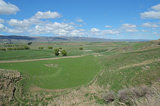
Lauder had a station on the former Otago Central Railway, now defunct, and served as a railway servicing town from the time the rails reached the town in 1904. [2] It remains a popular stopover on the Otago Central Rail Trail. [3] Lauder is the closest settlement to the Poolburn Gorge, a popular sight on the rail trail.

Otago Central Railway

The Otago Central Railway (OCR) or in later years Otago Central Branch Railway, now often referred to as the Taieri Gorge Railway, was a secondary railway line in Central Otago, in the South Island of New Zealand.

Otago Central Rail Trail New Zealand rail trail

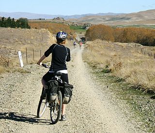
The Otago Central Rail Trail is a 150-kilometre walking, cycling and horse riding track in the South Island of New Zealand. A pioneering project for New Zealand, the successful cycle trail joined the New Zealand Cycle Trail umbrella organisation in 2012, having been one of the inspirations for it.

Poolburn Gorge canyon in New Zealand

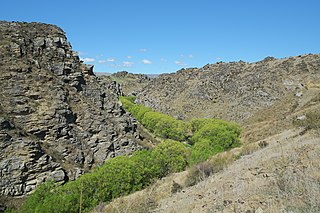
The Poolburn Gorge is a gorge located in the Central Otago region of the South Island of New Zealand, 4 km east of the small settlement of Lauder. The Ida Burn flows through the 2.5 km long canyon across the Raggedy Range between the Ida Valley and the Manuherikia Valley. There are no public roads through the gorge; only the track of the former Otago Central Railway, now used as the Otago Central Rail Trail, follows the river on the southern flanks of the gorge.

Atmospheric Research

Lauder's clear skies, low horizons, dry atmosphere, and southern latitude location make it an ideal site for atmospheric research.

The NIWA atmospheric research laboratory takes atmospheric measurements for the purpose of observing and better understanding interactions between the stratosphere, troposphere and global climate. This is achieved through measurements of ozone, ozone depleting substances (ODS), solar radiation, aerosols and greenhouse gases.

Stratosphere The layer of the atmosphere above the troposphere

The stratosphere is the second major layer of Earth's atmosphere, just above the troposphere, and below the mesosphere. The stratosphere is stratified (layered) in temperature, with warmer layers higher and cooler layers closer to the Earth; this increase of temperature with altitude is a result of the absorption of the Sun's ultraviolet radiation by the ozone layer. This is in contrast to the troposphere, near the Earth's surface, where temperature decreases with altitude. The border between the troposphere and stratosphere, the tropopause, marks where this temperature inversion begins. Near the equator, the stratosphere starts at as high as 18 km|sigfig=2|ft mi|abbr=on}}, around 10 km at midlatitudes, and at about 7 km at the poles. Temperatures range from an average of −51 °C near the tropopause to an average of −15 °C near the mesosphere. Stratospheric temperatures also vary within the stratosphere as the seasons change, reaching particularly low temperatures in the polar night (winter). Winds in the stratosphere can far exceed those in the troposphere, reaching near 60 m/s in the Southern polar vortex.

Troposphere The lowest layer of the atmosphere

The troposphere is the lowest layer of Earth's atmosphere, and is also where nearly all weather conditions take place. It contains approximately 75% of the atmosphere's mass and 99% of the total mass of water vapor and aerosols. The average height of the troposphere is 18 km in the tropics, 17 km in the middle latitudes, and 6 km in the polar regions in winter. The total average height of the troposphere is 13 km.

Climate Statistics of weather conditions in a given region over long periods

Climate is the statistics of weather over long periods of time. It is measured by assessing the patterns of variation in temperature, humidity, atmospheric pressure, wind, precipitation, atmospheric particle count and other meteorological variables in a given region over long periods of time. Climate differs from weather, in that weather only describes the short-term conditions of these variables in a given region.

The clear night air around Lauder also makes the area popular with both amateur and professional astronomers.

Related Research Articles

Clutha River river in New Zealand

The Clutha River / Mata-Au is the second longest river in New Zealand and the longest in the South Island. It flows south-southeast 338 kilometres (210 mi) through Central and South Otago from Lake Wanaka in the Southern Alps to the Pacific Ocean, 75 kilometres (47 mi) south west of Dunedin. It is the highest volume river in New Zealand, and the swiftest, with a catchment of 21,960 square kilometres (8,480 sq mi), discharging a mean flow of 614 cubic metres per second (21,700 cu ft/s). The Clutha River is known for its scenery, gold-rush history, and swift turquoise waters. A river conservation group, the Clutha Mata-Au River Parkway Group, is working to establish a regional river parkway, with a trail, along the entire river corridor. The name of the river was changed to a dual name by the Ngai Tahu Claims Settlement Act 1998.

Milton, New Zealand town in New Zealand

Milton, formerly known as Tokomairiro or Tokomairaro, is a town of 2,000 people, located on State Highway 1, 50 kilometres to the south of Dunedin in Otago, New Zealand. It lies on the floodplain of the Tokomairaro River, one branch of which loops past the north and south ends of the town. This river gives its name to many local features, notably the town's main school, Tokomairiro High School.

West Otago is the local name given to part of the region of Otago, New Zealand, lying close to the border with Southland. It is administratively connected to South Otago, but is geographically separated from it by a range of hills known as the Blue Mountains. The largest settlements in West Otago are Tapanui and Heriot, and other localities within the area include Moa Flat, Edievale, Merino Downs, and Waikoikoi. The area described as West Otago is sometimes extended to include Lawrence and Beaumont. The ghost town of Kelso also lies within West Otago. Other notable features of the area include Conical Hill and Landslip Hill, the latter being a major fossil-bearing formation.

Clyde, New Zealand Town in Otago, New Zealand

Clyde, formerly Dunstan, is a small town in Central Otago, New Zealand with a population of 918 in 2006. It is located on the Clutha River, between Cromwell and Alexandra.

The National Institute of Water and Atmospheric Research or NIWA, is a Crown Research Institute of New Zealand. Established in 1992, NIWA conducts commercial and non-commercial research across a broad range of disciplines in the environmental sciences. It also maintains nationally and, in some cases, internationally important environmental monitoring networks, databases, and collections.

Paerau is a small settlement in inland Central Otago in New Zealand's South Island. It is located in the upper valley of the Taieri River, at the foot of the Rock and Pillar Range. "Paerau" is a Māori-language name meaning "one hundred ridges".

Beaumont, New Zealand settlement in Otago Region of New Zealand

Beaumont is a small town in inland Otago, in the South Island of New Zealand. It is located on the Clutha River six kilometres southeast of Raes Junction, between Roxburgh and Balclutha. Beaumont is connected to Milton and Roxburgh by State Highway 8.

Ettrick, New Zealand town in Central Otago District, Otago Region, New Zealand

Ettrick is a small town in inland Otago, in the South Island of New Zealand.

Omakau human settlement in New Zealand

Omakau is a settlement in Central Otago, New Zealand, located between Alexandra and Ranfurly on the northwest bank of the Manuherikia River. The smaller settlement of Ophir, New Zealand is located on the opposite bank, three kilometres to the southeast.

Hyde, New Zealand settlement in Otago Region, New Zealand

Hyde is a locality in Otago, New Zealand, located in the Strath-Taieri. It is close to the northern end of the Rock and Pillar Range on State Highway 87 between Middlemarch and Ranfurly.

Kelso, New Zealand human settlement

Kelso is an abandoned small settlement in Otago, New Zealand, located ten kilometres north of Tapanui on the Crookston Burn, close to its junction with the larger Pomahaka River. Its population during the 1960s and 1970s was close to 300, with most of its economy based on sheep farming. A small dairy factory was a focal point in the village's early years.

St Leonards, Dunedin Suburb of the New Zealand city of Dunedin

St Leonards is a suburb of the New Zealand city of Dunedin. It is located close to the northern shore of the Otago Harbour and on the hilly slopes above the harbour. St Leonards is 8.5 kilometres (5.3 mi) northeast of Dunedin's city centre, between the small settlement of Burkes and Sawyers Bay. St Leonards was named by early settler David Carey for the birthplace of his wife, the English town of St Leonards-on-Sea, on the Sussex coast.

Ravensbourne, New Zealand

Ravensbourne is a suburb of the New Zealand city of Dunedin. It is located on the steep southeastern slopes of Signal Hill above the Otago Harbour. It lies on the harbour's northern shore, 4.5 kilometres (2.8 mi) east-northeast of the city centre. Ravensbourne's 2001 population was 1,269.

Styx Creek is a small to medium-sized natural stream in the Central Otago region of New Zealand. It flows into the Taieri River in the valley near Paerau, about 70 kilometres (43 mi) northwest of Dunedin.

Ophir, New Zealand human settlement

Ophir is a small settlement in Central Otago, New Zealand, located between Alexandra and Ranfurly close to the east bank of the Manuherikia River. The settlement of Omakau is located on the opposite bank, 3 kilometres (1.9 mi) to the northwest.

Gerald Garrick Cunningham is a New Zealand author, photographer, historian and businessman.

Bendigo, New Zealand human settlement in New Zealand

Bendigo is a settlement and historic area in Central Otago, in the southern South Island of New Zealand. It is located some 20 kilometres to the north of Cromwell, to the east of the head of Lake Dunstan, on the banks of the Bendigo Creek, a small tributary of the Clutha River.

Ida Valley human settlement in New Zealand

The Ida Valley lies east of the Manuherikia Valley in Central Otago, New Zealand. At an altitude of around 500 m (1,600 ft), the 40 km long flat and wide valley is a relatively dry region with cold winters and hot summers, much like the rest of Central Otago. The majority of agricultural production in the Ida Valley is lamb, including merino, and also stud cattle. The valley is named after the Ida Burn, which joins the Poolburn and breaks through the Raggedy Range via the Poolburn Gorge.

References

  1. Reed, A.W. (1975) Place names of New Zealand. Wellington: A.H. & A.W. Reed. p. 223
  2. 1 2 Lauder at visit-newzealand.com Retrieved 11 April 2015.
  3. Otago Central Rail Trail

Coordinates: 45°03′10″S169°40′20″E / 45.05278°S 169.67222°E / -45.05278; 169.67222

Geographic coordinate system Coordinate system

A geographic coordinate system is a coordinate system that enables every location on Earth to be specified by a set of numbers, letters or symbols. The coordinates are often chosen such that one of the numbers represents a vertical position and two or three of the numbers represent a horizontal position; alternatively, a geographic position may be expressed in a combined three-dimensional Cartesian vector. A common choice of coordinates is latitude, longitude and elevation. To specify a location on a plane requires a map projection.