Otago is a region of New Zealand located in the southern half of the South Island administered by the Otago Regional Council. It has an area of approximately 32,000 square kilometres (12,000 sq mi), making it the country's second largest local government region. Its population was 254,600 in June 2023.

Oamaru is the largest town in North Otago, in the South Island of New Zealand, it is the main town in the Waitaki District. It is 80 kilometres (50 mi) south of Timaru and 120 kilometres (75 mi) north of Dunedin on the Pacific coast; State Highway 1 and the railway Main South Line connect it to both cities. With a population of 14,000, Oamaru is the 28th largest urban area in New Zealand, and the third largest in Otago behind Dunedin and Queenstown. The town is the seat of Waitaki District, which includes the surrounding towns of Kurow, Weston, Palmerston, and Hampden, which combined have a total population of 23,200.

North Otago is an area in New Zealand covers the area of the Otago region between Shag Point and the Waitaki River, and extends inland to the west as far as the village of Omarama.

The Waitaki River is a large braided river in the South Island of New Zealand. It drains the Mackenzie Basin and runs 209 kilometres (130 mi) south-east to enter the Pacific Ocean between Timaru and Oamaru on the east coast. It starts at the confluence of the Ōhau and Tekapo rivers, now at the head of the artificial Lake Benmore, these rivers being fed by three large glacial lakes, Pukaki, Tekapo, and Ōhau at the base of the Southern Alps. The Waitaki flows through Lake Benmore, Lake Aviemore and Lake Waitaki, these lakes being contained by hydroelectric dams, Benmore Dam, Aviemore Dam and Waitaki Dam. The Waitaki has several tributaries, notably the Ahuriri River and the Hakataramea River. It passes Kurow and Glenavy before entering the Pacific Ocean. The River lends its name the Waitaki District on the south side of the river bank.

Kurow is a small town in the Waitaki District, New Zealand. It is located on the south bank of the Waitaki River, 60 kilometres (37 mi) northwest of Oamaru.

Lindis Pass is located in the South Island of New Zealand. A carpark at the top of the pass provides access to a viewpoint and two short trails to other viewing spots.

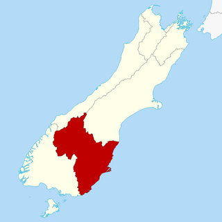
Waitaki District is a territorial authority district that is located in the Canterbury and Otago regions of the South Island of New Zealand. It straddles the traditional border between the two regions, the Waitaki River, and its seat is Oamaru.

The Maniototo Plain, usually simply known as The Maniototo, is an elevated inland region in Otago, New Zealand. The region roughly surrounds the upper reaches of the Taieri River and the Manuherikia River. It is bounded by the Kakanui Range to the north and the Rock and Pillar Range to the southeast. It has a harsh, dry climate, ranging from over 30 °C in mid-summer to -15 °C in mid-winter.

Ranfurly is a town in the Central Otago District of Otago, New Zealand. Located 110 kilometres north of Dunedin, it lies in the dry rough plain of Maniototo at a moderately high altitude close to a small tributary of the Taieri River. It operates as a service town for the local farming community. The town was formerly known as Eweburn, one of the "farmyard" names bestowed by former Otago Chief Surveyor John Turnbull Thomson on many small streams and locations in the district. The modern name honours the Fifth Earl of Ranfurly, who served as Governor of New Zealand (1897–1904) at the time of the extension of the Otago Central Railway to the area. Ranfurly is well known for its Art Deco buildings, such as its hotel and the dairy.

The small town of Kakanui lies on the coast of Otago, in New Zealand, fourteen kilometres to the south of Oamaru. The Kakanui River and its estuary divide the township in two. The part of the settlement south of the river, also known as Kakanui South, formerly "Campbells Bay", was developed as a collection of cribs. A recent increase in the development of subdivisions has increased the density of dwellings within South Kakanui.

The Kakanui Range is a range of high hills located inland from Oamaru in the South Island of New Zealand. The range forms a boundary between the valley of the Waitaki River to the north and the high plateau known as the Maniototo and the upper watershed of the Taieri River to the southwest. The highest point in the Kakanui Range is Mount Pisgah, at 1643 m (5394 ft).
The Kurow Branch was part of New Zealand's national rail network. In the North Otago region of the South Island, it was built in the 1870s to open up the land behind Oamaru for development, and closed in 1983.

Duntroon is a small farming-town in the Waitaki District of New Zealand's South Island. Although traditionally considered a North Otago town, it is located as of 2018 within the farthest southern reaches of Canterbury. Just north of the town runs the Waitaki River, which forms the traditional border between the two regions, although the official border has moved south to put most of Waitaki District, including Duntroon, within Canterbury. To the east of the village runs the Maerewhenua River. Near the village are the Earthquakes, a limestone-cliff formation.
This is a list of placenames in Scotland which have subsequently been applied to parts of New Zealand by Scottish emigrants or explorers.
State Highway 85 (SH 85) is a South Island state highway in New Zealand, servicing the Maniototo Plains and the North and Central Otago regions of the South Island between the major settlements of Alexandra and Palmerston. It is wholly two lane and passes through some of the most extreme climatic regions in New Zealand. The highway is known colloquially as "The Pigroot". Though there is no definitive explanation for this name, A. W. Reed, in his book Place Names of New Zealand, mentions an incident during John Turnbull Thomson's survey of inland Otago in which local wild pigs were so unafraid of humans that a huge boar approached his party and rubbed its nose against that of Thomson's horse.

State Highway 87 (SH 87) is a state highway in New Zealand servicing the Taieri Plains and the Strath-Taieri Valley in Otago, connecting Mosgiel to Kyeburn on the eastern flank of the Maniototo Plains.
Kyeburn is a small settlement in Otago, in the South Island of New Zealand. It lies on the Maniototo, a wide, high plain stretching from the end of the Strath-Taieri valley.
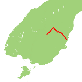
Danseys Pass is a locality in Waitaki District in the Canterbury region of New Zealand. The settlement is located approximately halfway between Danseys Pass and Duntroon on the Canterbury side of the pass. The pass and road are named after William Heywood Dansey. He was the lessee of the Otekaike run from 1857 to 1871 who, in 1855 with three companions, was the first European to cross the pass in search for land in the Maniototo district.
Maruakoa is a small farming settlement in Waitaki District, New Zealand. It is located close to the banks of the Kakanui River just south of its emergence form the Kakanui Gorge. It is 18 kilometres northwest of Oamaru and 4 kilometres southwest of Windsor, between the two settlements of Five Forks and Tapui. The name Maruakoa is a Māori word literally meaning "Happy valley".

