Ranfurly, New Zealand

Last updated

Ranfurly
Settlement
Ranfurlyhotel.jpg
The main street of Ranfurly
Ranfurly, New Zealand
Coordinates: 45°08′S170°06′E / 45.133°S 170.100°E / -45.133; 170.100
CountryNew Zealand
Region Otago
Territorial authority Central Otago District
WardManiototo Ward
CommunityManiototo Community
Electorates
Government
  Territorial authority Central Otago District Council
  Regional council Otago Regional Council
   Mayor of Central Otago Tim Cadogan
   Waitaki MP Miles Anderson
   Te Tai Tonga MP Tākuta Ferris
Area
[1]
  Urban area3.86 km2 (1.49 sq mi)
Population
 (June 2023) [2]
  Urban area780
  Density200/km2 (520/sq mi)
Time zone UTC+12 (NZST)
  Summer (DST) UTC+13 (NZDT)

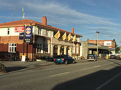
Ranfurly is a town in the Central Otago District of Otago, New Zealand. Located 110 kilometres (68 miles) north of Dunedin, it lies in the dry rough plain of Maniototo at a moderately high altitude (around 430 metres or 1,410 feet above sea level) close to a small tributary of the Taieri River. It operates as a service town for the local farming community. The town was formerly known as Eweburn, one of the "farmyard" names bestowed by former Otago Chief Surveyor John Turnbull Thomson on many small streams and locations in the district. The modern name honours the Fifth Earl of Ranfurly, who served as Governor of New Zealand (1897–1904) at the time of the extension of the Otago Central Railway to the area. Ranfurly is well known for its Art Deco buildings, such as its hotel and the dairy.

Contents

History

During the Central Otago goldrush of the 1860s, several important deposits of the precious metal were found near Ranfurly, notably at Kyeburn and Naseby, close to the southwestern face of the Kakanui Range.

After the gold-rush faded Ranfurly grew at the expense of Naseby, spurred by the arrival of the railway in 1898. The rail line was closed in 1989 and the track removed, but its course became a major walking and cycling route, the Otago Central Rail Trail, which attracts tourists. The former railway station now serves as a museum and display centre.

The town became an important service-centre for the rural community, experiencing a building boom in the 1930s. It has a large proportion of rural Art Deco buildings which have been preserved from that time. An annual festival commemorating Ranfurly's Art Deco heritage used to take place each February.

The nearby Ida Valley functioned as one of the locations for Peter Jackson's 2001–2003 Lord of the Rings film trilogy, representing the wide plains of Rohan.

Climate

Under the Köppen climate classification Ranfurly has an oceanic climate (Cfb), with continental influence.

Central Otago in general, and the Maniototo in particular, has one of New Zealand's very few zones influenced by continental climates, with large daily and seasonal temperature extremes. Average highs in summer are around 22 °C (72 °F), with occasional days as warm as 30 °C (86 °F); average winter highs are around 7 °C (45 °F), with the coldest nights below −5 °C (23 °F). The lowest temperature on record in New Zealand (−25.6 °C or −14.1 °F) was recorded at Ranfurly in 1903. [3] Heavy frosts are common throughout winter.

The town is sheltered from the prevailing rain patterns by the mountains to the west. The Nor'wester foehn wind is thus a frequent weather pattern, and annual rainfall is only in the region of 400–500 mm (16–20 in).

Climate data for Ranfurly, elevation 450 m (1,480 ft), (1991–2020)
MonthJanFebMarAprMayJunJulAugSepOctNovDecYear
Mean daily maximum °C (°F)22.0
(71.6)
21.9
(71.4)
19.7
(67.5)
15.7
(60.3)
11.8
(53.2)
8.2
(46.8)
7.9
(46.2)
10.3
(50.5)
13.5
(56.3)
15.7
(60.3)
17.9
(64.2)
20.5
(68.9)
15.4
(59.8)
Daily mean °C (°F)15.1
(59.2)
14.7
(58.5)
12.5
(54.5)
9.2
(48.6)
6.1
(43.0)
3.0
(37.4)
2.6
(36.7)
4.6
(40.3)
7.2
(45.0)
9.2
(48.6)
11.2
(52.2)
13.7
(56.7)
9.1
(48.4)
Mean daily minimum °C (°F)8.1
(46.6)
7.4
(45.3)
5.4
(41.7)
2.7
(36.9)
0.4
(32.7)
−2.2
(28.0)
−2.6
(27.3)
−1.1
(30.0)
1.0
(33.8)
2.8
(37.0)
4.6
(40.3)
6.9
(44.4)
2.8
(37.0)
Average rainfall mm (inches)57.1
(2.25)
44.7
(1.76)
35.1
(1.38)
37.0
(1.46)
34.0
(1.34)
33.1
(1.30)
23.3
(0.92)
23.0
(0.91)
28.0
(1.10)
37.2
(1.46)
42.2
(1.66)
61.2
(2.41)
455.9
(17.95)
Source: NIWA [4]
Climate data for Ranfurly (2000-2024 normals, extremes 1897-1922, 1975-2024)
MonthJanFebMarAprMayJunJulAugSepOctNovDecYear
Record high °C (°F)33.7
(92.7)
33.5
(92.3)
30.8
(87.4)
27.8
(82.0)
22.7
(72.9)
18.6
(65.5)
17.6
(63.7)
23
(73)
23.6
(74.5)
26.8
(80.2)
29.2
(84.6)
32.3
(90.1)
33.7
(92.7)
Mean maximum °C (°F)30.4
(86.7)
29.9
(85.8)
27.3
(81.1)
23
(73)
19.1
(66.4)
16
(61)
14.9
(58.8)
16.9
(62.4)
20.3
(68.5)
23.2
(73.8)
25.8
(78.4)
28.6
(83.5)
31.5
(88.7)
Mean daily maximum °C (°F)22.4
(72.3)
22.1
(71.8)
19.9
(67.8)
16.1
(61.0)
12
(54)
8.6
(47.5)
8.2
(46.8)
10.7
(51.3)
13.8
(56.8)
15.8
(60.4)
18.3
(64.9)
20.8
(69.4)
15.7
(60.3)
Daily mean °C (°F)15.3
(59.5)
14.8
(58.6)
12.8
(55.0)
9.5
(49.1)
6.3
(43.3)
3.2
(37.8)
2.9
(37.2)
5
(41)
7.5
(45.5)
9.3
(48.7)
11.7
(53.1)
14
(57)
9.4
(48.8)
Mean daily minimum °C (°F)8.2
(46.8)
7.5
(45.5)
5.6
(42.1)
2.9
(37.2)
0.6
(33.1)
−2.1
(28.2)
−2.4
(27.7)
−0.8
(30.6)
1.2
(34.2)
2.7
(36.9)
5
(41)
7.3
(45.1)
3.0
(37.4)
Mean minimum °C (°F)1.4
(34.5)
1
(34)
−1
(30)
−3.6
(25.5)
−6
(21)
−7.9
(17.8)
−8
(18)
−6.6
(20.1)
−4.9
(23.2)
−3.7
(25.3)
−1.6
(29.1)
0.8
(33.4)
−9
(16)
Record low °C (°F)−2.8
(27.0)
−3.3
(26.1)
−8.9
(16.0)
−10.6
(12.9)
−14.5
(5.9)
−15
(5)
−25.6
(−14.1)
−18.3
(−0.9)
−12.2
(10.0)
−8.9
(16.0)
−5.6
(21.9)
−3.9
(25.0)
−25.6
(−14.1)
Source: [5]


Ranfurly's Art Deco milk bar Centennial Milk Bar building.jpg
Ranfurly's Art Deco milk bar

Demographics

Ranfurly is described by Statistics New Zealand as a rural settlement. It covers 3.86 km2 (1.49 sq mi) [1] and had an estimated population of 780 as of June 2023, [2] with a population density of 202 people per km2. It is part of the much larger Maniototo statistical area. [6]

Historical population
YearPop.±% p.a.
2006714    
2013666−0.99%
2018726+1.74%
Source: [7]

Ranfurly had a population of 726 at the 2018 New Zealand census, an increase of 60 people (9.0%) since the 2013 census, and an increase of 12 people (1.7%) since the 2006 census. There were 333 households, comprising 348 males and 375 females, giving a sex ratio of 0.93 males per female, with 90 people (12.4%) aged under 15 years, 93 (12.8%) aged 15 to 29, 288 (39.7%) aged 30 to 64, and 246 (33.9%) aged 65 or older.

Ethnicities were 91.3% European/Pākehā, 12.8% Māori, 1.2% Pasifika, 3.3% Asian, and 0.4% other ethnicities. People may identify with more than one ethnicity.

Although some people chose not to answer the census's question about religious affiliation, 43.4% had no religion, 48.8% were Christian, 0.4% were Hindu and 0.8% had other religions.

Of those at least 15 years old, 48 (7.5%) people had a bachelor's or higher degree, and 192 (30.2%) people had no formal qualifications. 57 people (9.0%) earned over $70,000 compared to 17.2% nationally. The employment status of those at least 15 was that 252 (39.6%) people were employed full-time, 105 (16.5%) were part-time, and 9 (1.4%) were unemployed. [7]

Sport

Ranfurly lies close to the heart of New Zealand's curling-playing region, and the local club have represented New Zealand at the 1999, 2004, and 2005 World Championships (finishing tenth, seventh and eighth respectively), as well as providing members for the New Zealand 2006 Winter Olympics curling team.

Ranfurly has been the birthplace of several recent members of the New Zealand women's (field) hockey team.

St John's Station St John Ranfurly.jpg
St John's Station

Education

Maniototo Area School is a co-educational state area school for Year 1 to 13 students, [8] [9] with a roll of 149 as of February 2024. [10] The school has predecessors from 1879. [11] [12]

St John's School is a co-educational state-integrated Catholic primary school for Year 1 to 8 students, [13] with a roll of 60 as of February 2024. [14] It was established in 1945. [15]

Notable people

Related Research Articles

<span class="mw-page-title-main">Balclutha, New Zealand</span> Town in Otago, New Zealand

Balclutha is a town in South Otago, lying towards the end of the Clutha River, on the east coast of the South Island of New Zealand. It is about halfway between Dunedin and Gore on the Main South Line railway, State Highway 1 and the Southern Scenic Route. Balclutha has a population of 4,340, and is the largest town in South Otago.

<span class="mw-page-title-main">Te Kūiti</span> Town in Waikato, New Zealand

Te Kūiti is a town in the north of the King Country region of the North Island of New Zealand. It lies at the junction of State Highways 3 and 30 and on the North Island Main Trunk railway, 80 kilometres (50 mi) south of Hamilton. The town promotes itself as the sheep shearing capital of the world and is host to the annual New Zealand National Shearing Championships.

<span class="mw-page-title-main">Middlemarch, New Zealand</span> Human settlement in Dunedin City, Otago Region, New Zealand

Middlemarch is a small town in the Otago region of New Zealand's South Island. It lies at the foot of the Rock and Pillar Range of hills in the broad Strath-Taieri valley, through which flows the middle reaches of the Taieri River. Since local government reorganisation in the late 1980s, Middlemarch and much of the Strath-Taieri has been administered as part of Dunedin city, the centre of which lies some 80 km to the southeast. Middlemarch is part of the Taieri electorate, and is currently represented in parliament by Ingrid Leary. Middlemarch has reticulated sewerage but no reticulated water supply. A description of 1903, that "[T]he summer seasons are warm, but not enervating, and the winters cold, but dry" is still true today.

<span class="mw-page-title-main">Naseby, New Zealand</span> Town in the South Island of New Zealand

Naseby is a small town, formerly a borough, in the Maniototo area of Central Otago, New Zealand. It is named after a village in Northamptonshire, England. Previous names of the township were Parker's, Hogburn and Mt Ida. The town catch phrase is "2000 feet above worry level" indicating its altitude. Naseby is 395 km from Christchurch and 143 km from Dunedin.

<span class="mw-page-title-main">Ōpōtiki</span> Town in the Bay of Plenty, New Zealand

Ōpōtiki is a town in the eastern Bay of Plenty in the North Island of New Zealand. It houses the headquarters of the Ōpōtiki District Council, the mayor of Ōpōtiki and comes under the Bay of Plenty Regional Council.

<span class="mw-page-title-main">Kawerau</span> Town in the Bay of Plenty, New Zealand

Kawerau is a town in the Bay of Plenty Region on the North Island of New Zealand. It is situated 100 km south-east of Tauranga and 58 km east of Rotorua. It is the seat of the Kawerau District Council, and the only town in Kawerau District.

<span class="mw-page-title-main">Tapanui</span> Town in Otago, New Zealand

Tapanui is a small town in West Otago in New Zealand's South Island, close to the boundary with Southland region.

<span class="mw-page-title-main">The Maniototo</span> Elevated inland region in Otago, New Zealand

The Maniototo Plain, usually simply known as The Maniototo, is an elevated inland region in Otago, New Zealand. The region roughly surrounds the upper reaches of the Taieri River and the Manuherikia River. It is bounded by the Kakanui Range to the north and the Rock and Pillar Range to the southeast. It has a harsh, dry climate, ranging from over 30 °C in mid-summer to -15 °C in mid-winter.

<span class="mw-page-title-main">Clyde, New Zealand</span> Town in Otago, New Zealand

Clyde, formerly Dunstan, is a small town in Central Otago, New Zealand with a population of 1,260 in June 2023. It is located on the Clutha River, between Cromwell and Alexandra.

<span class="mw-page-title-main">Glenorchy, New Zealand</span> Town in Otago, New Zealand

Glenorchy is a small settlement at the northern end of Lake Wakatipu in the South Island region of Otago, New Zealand. It is approximately 45 km (28 mi) by road or boat from Queenstown, the nearest large town. There are two pubs, a café and a range of small shops in the town catering mainly to tourists but also to the small resident population. There is also a small airstrip which caters to small planes.

<span class="mw-page-title-main">Taieri Mouth</span> Rural settlement in Otago, New Zealand

Taieri Mouth is a small fishing village at the mouth of the Taieri River, New Zealand. Taieri Island (Moturata) lies in the ocean several hundred metres off the river's mouth.

<span class="mw-page-title-main">Katikati</span> Town in the Bay of Plenty, New Zealand

Katikati is a town in New Zealand located on the Uretara Stream near a tidal inlet towards the northern end of Tauranga Harbour, 28 kilometres south of Waihi and 40 kilometres northwest of Tauranga. State Highway 2 passes through the town; a bypass scheduled to have begun construction in 2008 is on hold.

<span class="mw-page-title-main">Murupara</span> Town in the Bay of Plenty Region, New Zealand

Murupara is a town in the Whakatāne District and Bay of Plenty Region of New Zealand's North Island. The town is in an isolated part of the region between the Kaingaroa Forest and Te Urewera protected area, on the banks of the Rangitaiki River, 65 kilometres southeast of Rotorua. Indigenous Māori also make up over 90% of the population.

<span class="mw-page-title-main">Central Otago District</span> Territorial authority district in Otago, New Zealand

Central Otago District is local government district in New Zealand. It is administered by the Central Otago District Council, and it is in the Otago region, the top tier of local government in New Zealand. The major towns in the district are Alexandra, Cromwell, Roxburgh, Clyde and Ranfurly. The district covers 9,968 km2 (3,849 sq mi), making it the fourth-largest district in New Zealand by area, and is home to 26,000 people as of June 2023.

<span class="mw-page-title-main">Owaka</span> Place in Otago, New Zealand

Owaka is a small town in the Clutha District of South Otago, in the South Island of New Zealand. It is the largest community in the rugged, forested Catlins area, close to the border with Southland, some 35 km (22 mi) south of Balclutha on the Southern Scenic Route.

<span class="mw-page-title-main">Omakau</span> Rural settlement in Otago, New Zealand

Omakau is a settlement in Central Otago, New Zealand, located between Alexandra and Ranfurly on the northwest bank of the Manuherikia River. The smaller settlement of Ophir, New Zealand is located on the opposite bank, three kilometres to the southeast.

Mōkau is a small town on the west coast of New Zealand's North Island, located at the mouth of the Mōkau River on the North Taranaki Bight. Mōkau is in the Waitomo District and Waikato region local government areas, just north of the boundary with the New Plymouth District and the Taranaki Region. Prior to 1989, the town was classed as being in Taranaki, and there is still a feeling that the community of interest is most associated with New Plymouth, 90 km to the southwest. State Highway 3 passes through the town on its route from Te Kūiti to Waitara and, eventually, New Plymouth.

<span class="mw-page-title-main">Wharekahika</span> Town in Gisborne District, New Zealand

Wharekahika or Hicks Bay is a bay and coastal area in the Gisborne District of the North Island of New Zealand. It is situated 150 km east of Ōpōtiki and 186 km north of Gisborne city, along State Highway 35 between Potaka and Te Araroa.

Piopio is a small town in the Waitomo District. It is situated on State Highway 3 approximately 23 km from Te Kūiti.

<span class="mw-page-title-main">Tuai</span> Settlement in Hawkes Bay Region, New Zealand

Tuai is a village and rural community located around Lake Whakamarino, in the Wairoa District of the Hawke's Bay Region, on New Zealand's North Island.

References

Commons-logo.svg Media related to Ranfurly, New Zealand at Wikimedia Commons

  1. 1 2 "ArcGIS Web Application". statsnz.maps.arcgis.com. Retrieved 7 December 2021.
  2. 1 2 "Subnational population estimates (RC, SA2), by age and sex, at 30 June 1996-2023 (2023 boundaries)". Statistics New Zealand . Retrieved 25 October 2023. (regional councils); "Subnational population estimates (TA, SA2), by age and sex, at 30 June 1996-2023 (2023 boundaries)". Statistics New Zealand . Retrieved 25 October 2023. (territorial authorities); "Subnational population estimates (urban rural), by age and sex, at 30 June 1996-2023 (2023 boundaries)". Statistics New Zealand . Retrieved 25 October 2023. (urban areas)
  3. "NZ's temperature record hits new low - minus 25.6degC". The New Zealand Herald. 12 July 2011. Retrieved 12 July 2011.
  4. "CliFlo – National Climate Database : Ranfurly Ews". NIWA. Retrieved 19 May 2024.
  5. "CliFlo -The National Climate Database (Agent numbers: 5276, 5280, 18593)". NIWA. Retrieved 9 May 2024.
  6. 2018 Census place summary: Maniototo
  7. 1 2 "Statistical area 1 dataset for 2018 Census". Statistics New Zealand. March 2020. 7027814–7027818.
  8. "Maniototo Area School Official School Website". maniototo.school.nz.
  9. "Maniototo Area School Ministry of Education School Profile". educationcounts.govt.nz. Ministry of Education.
  10. "Maniototo Area School Education Review Office Report". ero.govt.nz. Education Review Office.
  11. "Newsletter - Opening Ceremony" (PDF). Maniototo Area School. 11 June 2021.
  12. "Post-Primary (Secondary) Schools in Otago and Southland" (PDF). Friends of the Hocken Collection. February 2009.
  13. "St John's SchoolMinistry of Education School Profile". educationcounts.govt.nz. Ministry of Education.
  14. "St John's School Education Review Office Report". ero.govt.nz. Education Review Office.
  15. "The History of The Sisters of Mercy in the Dunedin Diocese". Mercy Schools. Retrieved 7 December 2021.