
Alexandra is a town in the Central Otago district of the South Island of New Zealand. It is on the banks of the Clutha River, on State Highway 8, 188 kilometres (117 mi) by road from Dunedin and 33 kilometres (21 mi) south of Cromwell. The nearest towns to Alexandra via state highway 8 are Clyde seven kilometers to the northwest and Roxburgh forty kilometers to the south. State highway 85 also connects Alexandra to Omakau, Lauder, Oturehua, Ranfurly and on to Palmerston on the East Otago coast.

Arrowtown is a historic gold mining town in the Otago region of the South Island of New Zealand. Arrowtown is located on the banks of the Arrow River approximately 7.5 km from State Highway 6. Arrowtown is located 19.5 kilometres to the east of Queenstown. As well as the route via State Highway 6 between Arrowtown and Queenstown, there is also road access directly to Queenstown via the Shotover Gorge and a third route via the picturesque Lake Hayes.
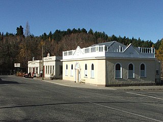
Naseby is a small town, formerly a borough, in the Maniototo area of Central Otago, New Zealand. It is named after a village in Northamptonshire, England. Previous names of the township were Parker's, Hogburn and Mt Ida. The town catch phrase is "2000 feet above worry level" indicating its altitude. Naseby is 395 km from Christchurch and 143 km from Dunedin.
South Otago lies in the south east of the South Island of New Zealand. As the name suggests, it forms the southernmost part of the geographical region of Otago.

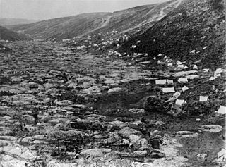
The Otago Gold Rush was a gold rush that occurred during the 1860s in Central Otago, New Zealand. This was the country's biggest gold strike, and led to a rapid influx of foreign miners to the area - many of them veterans of other hunts for the precious metal in California and Victoria, Australia.
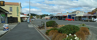
Roxburgh is a small New Zealand town of about 600 people in Central Otago. It is in Teviot Valley on the banks of the Clutha River, 40 kilometres (25 mi) south of Alexandra in the South Island. State Highway 8, which links Central Otago with Dunedin city, passes through the town. Roxburgh is well known for its Summer fruit and "Jimmy's Pies."
The 1860–1861 New Zealand general election was held between 12 December 1860 and 28 March 1861 to elect 53 MPs to the third session of the New Zealand Parliament. 13,196 electors were registered.

Millers Flat is a small town in inland Otago, in the South Island of New Zealand. It is located on the Clutha River, 17 kilometres south of Roxburgh. Fruit growing is the main industry in the area. Most of the town lies on the north bank of the Clutha; the main road, State Highway 8, passes close by on the river's other bank. The Roxburgh Branch railway used to pass through the town; it was opened to Millers Flat in 1925 and was the terminus for approximately two and a half years, until the section to Roxburgh was opened. The line was closed in 1968, though the town's station platform and some of the railway formation still exist.

Hyde is a locality in Otago, New Zealand, located in the Strath-Taieri. It is close to the northern end of the Rock and Pillar Range on State Highway 87 between Middlemarch and Ranfurly. Hyde is best known as the site of the Hyde railway disaster of 4 June 1943, in which 21 people were killed when an express train on the Otago Central Railway derailed at high speed in a cutting near the town. At the time, it was the worst railway accident in New Zealand's history; it has only been passed by the Tangiwai disaster of 24 December 1953, which claimed the lives of 151 people. The site of the Hyde disaster can now be walked as part of the Otago Central Rail Trail and a monument, a 2.5 m high cairn, stands as a memorial to the victims.
The township of Oturehua is in the Ida Valley of the Maniototo, in Central Otago, in the South Island of New Zealand.

South Dunedin is a major inner city suburb of the New Zealand city of Dunedin. It is located, as its name suggests, 2.5 kilometres (1.6 mi) to the south of the city centre, on part of a large plain known locally simply as "The Flat". The suburb is a mix of industrial, retail, and predominantly lower-quality residential properties.
Taieri is a parliamentary electorate in the Otago region of New Zealand, initially from 1866 to 1911, and was later recreated during the 2019/20 electoral redistribution ahead of the 2020 election.

Edward Bowes Cargill was a 19th-century businessman and Member of Parliament in Dunedin, Otago, New Zealand. He was the Mayor of Dunedin from 1897 to 1898.
The Gold Fields District electorate was a 19th-century parliamentary electorate in the Otago region, New Zealand. It was created in 1862, with the first elections in the following year, and it returned two members. It was one of eventually three special interest constituencies created to meet the needs of gold miners. All three of these electorates were abolished in 1870. A unique feature of the Gold Fields District was that it was superimposed over other electorates, and voting was open to those who had held a mining license for some time. As such, suffrage was more relaxed than elsewhere in New Zealand, as voting was otherwise tied to property ownership. Another feature unique to the gold mining electorates was that no electoral rolls were prepared, but voting could be done upon showing a complying miner's license.
City of Dunedin, during the first two parliaments called Town of Dunedin, was a parliamentary electorate in Dunedin in Otago, New Zealand. It was one of the original electorates created in 1853 and existed, with two breaks, until 1905. The first break, from 1862 to 1866, was caused by an influx of people through the Otago Gold Rush, when many new electorates were formed in Otago. The second break occurred from 1881 to 1890. It was the only New Zealand electorate that was created as a single-member, two-member and three member electorate.
Roslyn was a parliamentary electorate in the city of Dunedin in the Otago region of New Zealand from 1866 to 1890.
The third New Zealand Parliament was a term of the Parliament of New Zealand. Elections for this term were held between 12 December 1860 and 28 March 1861 in 43 electorates to elect 53 MPs. Two electorates were added to this during this term, Gold Fields District and a new Dunedin electorate created by splitting the existing City of Dunedin into Dunedin and Suburbs North and Dunedin and Suburbs South, increasing the number of MPs to 57. During the term of this Parliament, six Ministries were in power.
Skippers Canyon is a historic and scenic gorge, some 22 kilometres in length, several kilometres north of Queenstown, New Zealand.
The blizzard and flood of 1863 was a series of consecutive natural disasters in Central Otago in New Zealand's South Island. In the early 1860s the area was in the midst of a gold rush. From July to August 1863 the gold fields suffered from a combination of floods, snowstorms, and blizzards that caused heavy loss of life among the gold miners. At least 40 died during the July rains and more than 11 in the August snows. Sources using the earliest reports of loss of life tend to greatly overstate the numbers who died.
William John Dyer was a New Zealand businessman and politician. Born in London, his family moved to Sydney when he was a child. He ran a trading business between Sydney, New Zealand and the Pacific Islands, and moved to New Zealand in 1857. He lived at different times in Dunedin and Milton and entered politics, contesting a number of elections and representing the Tokomairaro electorate in the provincial council.


