
Otago is a region of New Zealand located in the southern half of the South Island administered by the Otago Regional Council. It has an area of approximately 32,000 square kilometres (12,000 sq mi), making it the country's second largest local government region. Its population was 254,600 in June 2023.

Queenstown is a resort town in Otago in the south-west of New Zealand's South Island. It has an urban population of 29,000.

Alexandra is a town in the Central Otago district of the South Island of New Zealand. It is on the banks of the Clutha River, on State Highway 8, 188 kilometres (117 mi) by road from Dunedin and 33 kilometres (21 mi) south of Cromwell. The nearest towns to Alexandra via state highway 8 are Clyde seven kilometers to the northwest and Roxburgh forty kilometers to the south. State highway 85 also connects Alexandra to Omakau, Lauder, Oturehua, Ranfurly and on to Palmerston on the East Otago coast.

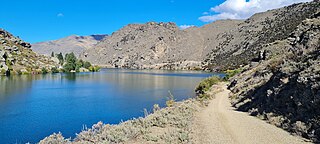
The Clutha River is the second longest river in New Zealand and the longest in the South Island. It flows south-southeast 338 kilometres (210 mi) through Central and South Otago from Lake Wānaka in the Southern Alps to the Pacific Ocean, 75 kilometres (47 mi) south west of Dunedin. It is the highest volume river in New Zealand, and the swiftest, with a catchment of 21,960 square kilometres (8,480 sq mi), discharging a mean flow of 614 cubic metres per second (21,700 cu ft/s). The river is known for its scenery, gold-rush history, and swift turquoise waters. A river conservation group, the Clutha Mata-Au River Parkway Group, is working to establish a regional river parkway, with a trail, along the entire river corridor.

Cromwell is a town in Central Otago region of the South Island of New Zealand. Cromwell is located on the shores of Lake Dunstan where the Kawarau river joins Lake Dunstan. Cromwell was established during the Otago gold rush and is now more known as one of the sub regions of the Central Otago wine region. In 2018, the town of Cromwell was home to a population of 5610 people.

Naseby is a small town, formerly a borough, in the Maniototo area of Central Otago, New Zealand. It is named after a village in Northamptonshire, England. Previous names of the township were Parker's, Hogburn and Mt Ida. The town catch phrase is "2000 feet above worry level" indicating its altitude. Naseby is 395 km from Christchurch and 143 km from Dunedin.
Central Otago is an area located in the inland part of the Otago region in the South Island of New Zealand. The motto for the area is "A World of Difference".

The Kawarau River is a river in the South Island of New Zealand. It drains Lake Wakatipu in northwestern Otago via the lake's Frankton Arm. The river flows generally eastwards for about 60 kilometres (37 mi) and passes through the steep Kawarau Gorge until it joins Lake Dunstan near Cromwell. Before the construction of the Clyde High Dam, the Kawarau joined the Clutha River / Mata-Au in a spectacular confluence at Cromwell. The Shotover River enters the Kawarau from the north; the Nevis River enters it from the south. With many rapids and strong currents, the river can be dangerous and has claimed many lives. It is popular for bungy jumping and kayaking.
The Cromwell Gorge is a steep gorge cut by the former Clutha River in the Central Otago region of New Zealand's South Island. It winds 19 km (12 mi) between the Dunstan and Cairnmuir Mountains, linking the townships of Cromwell and Clyde. It is one of three substantial river gorges in Central Otago, the others being the Kawarau Gorge to the west of Cromwell, and the Roxburgh Gorge south of Alexandra.

The Otago Gold Rush was a gold rush that occurred during the 1860s in Central Otago, New Zealand. This was the country's biggest gold strike, and led to a rapid influx of foreign miners to the area – many of them veterans of other hunts for the precious metal in California and Victoria, Australia.

Clyde, formerly Dunstan, is a small town in Central Otago, New Zealand with a population of 1,260 in June 2023. It is located on the Clutha River, between Cromwell and Alexandra.

The Central Otago wine region is a geographical indication in New Zealand's South Island, and the world's southernmost commercial wine growing region. While Central Otago is best known for Pinot Noir, many white wine varieties are also popular.

New Zealand wine is produced in several of its distinct winegrowing regions. As an island country in the South Pacific Ocean, New Zealand has a largely maritime climate, although its elongated geography produces considerable regional variation from north to south. Like many other New World wines, New Zealand wine is usually produced and labelled as single varietal wines, or if blended, winemakers list the varietal components on the label. New Zealand is best known for its Marlborough Sauvignon Blanc, and more recently its dense, concentrated Pinot Noir from Marlborough, Martinborough and Central Otago.

Tarras is a small farming settlement in Central Otago, in the South Island of New Zealand.

The Kawarau Gorge is a major river gorge created by the Kawarau River in Central Otago, in the South Island of New Zealand. The towns of Queenstown and Cromwell are linked by State Highway 6 through the gorge.

Gibbston is a community in the Wakatipu Basin in the Otago region of the South Island, New Zealand. Through the valley runs the Kawarau River which forms the Kawarau Gorge.

Bendigo is a settlement and historic area in Central Otago, in the southern South Island of New Zealand. It is located some 20 kilometres to the north of Cromwell, to the east of the head of Lake Dunstan, on the banks of the Bendigo Creek, a small tributary of the Clutha River.
Earnscleugh is a small settlement and rural community, based alongside the Earnscleugh River in the Central Otago District, in the Otago region of New Zealand's South Island.
Pisa Moorings is a small town in the Central Otago District of Otago region of New Zealand's South Island. It is located between Lake Dunstan on its east and State Highway 6 on its west. Cromwell is 9 km southwest and Wānaka is 45 km north by road.
The Bendigo Goldfields region of Central Otago is an historic area comprising several former mining settlements in the southern South Island of New Zealand. It was part of the Otago Gold Rush that occurred during the 1860s, leading to an influx of miners from rushes in California and Victoria, Australia. These miners brought with them a rich diversity of cultures from England, Scotland, Wales, Ireland, Sweden, China, Australia, Canada, and the United States. The area was named after the goldfield by the same name in Victoria.


