
Alexandra is a town in the Central Otago district of the South Island of New Zealand. It is on the banks of the Clutha River, on State Highway 8, 188 kilometres (117 mi) by road from Dunedin and 33 kilometres (21 mi) south of Cromwell. The nearest towns to Alexandra via state highway 8 are Clyde seven kilometres to the northwest and Roxburgh forty kilometres to the south. State highway 85 also connects Alexandra to Omakau, Lauder, Oturehua, Ranfurly and on to Palmerston on the East Otago coast.

Cromwell is a town in Central Otago region of the South Island of New Zealand. Cromwell is located on the shores of Lake Dunstan where the Kawarau river joins Lake Dunstan. Cromwell was established during the Otago gold rush and is now more known as one of the sub regions of the Central Otago wine region. In 2018, the town of Cromwell was home to a population of 5610 people.

Naseby is a small town, formerly a borough, in the Maniototo area of Central Otago, New Zealand. It is named after a village in Northamptonshire, England. Previous names of the township were Parker's, Hogburn and Mt Ida. The town catch phrase is "2000 feet above worry level" indicating its altitude. Naseby is 395 km from Christchurch and 143 km from Dunedin.
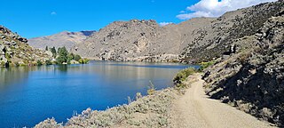
The Cromwell Gorge is a steep gorge cut by the former Clutha River in the Central Otago region of New Zealand's South Island. It winds 19 km (12 mi) between the Dunstan and Cairnmuir Mountains, linking the townships of Cromwell and Clyde. It is one of three substantial river gorges in Central Otago, the others being the Kawarau Gorge to the west of Cromwell, and the Roxburgh Gorge south of Alexandra.

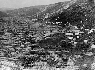
The Otago gold rush was a gold rush that occurred during the 1860s in Central Otago, New Zealand. This was the country's biggest gold strike, and led to a rapid influx of foreign miners to the area – many of them veterans of other hunts for the precious metal in California and Victoria, Australia. The number of miners reached its maximum of 18,000 in February 1864.

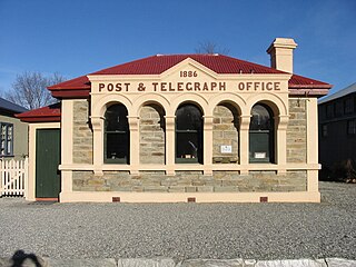
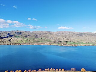
Clyde, formerly Dunstan, is a small town in Central Otago, New Zealand with a population of 1,260 in June 2023. It is located on the Clutha River, between Cromwell and Alexandra.

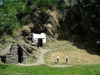
St Bathans, formerly named Dunstan Creek, is a former gold and coal mining town in Central Otago, New Zealand. The settlement was a centre of the Otago gold rush, but mining has since long ceased. It is now largely a holiday retreat due to the preservation of many of its historic buildings.

Heritage New Zealand Pouhere Taonga is a Crown entity with a membership of around 20,000 people that advocates for the protection of ancestral sites and heritage buildings in New Zealand. It was set up through the Historic Places Act 1954 with a mission to "...promote the identification, protection, preservation and conservation of the historical and cultural heritage of New Zealand" and is an autonomous Crown entity. Its current enabling legislation is the Heritage New Zealand Pouhere Taonga Act 2014.

Hyde is a locality in Otago, New Zealand, located in the Strath-Taieri. It is close to the northern end of the Rock and Pillar Range on State Highway 87 between Middlemarch and Ranfurly. Hyde is best known as the site of the Hyde railway disaster of 4 June 1943, in which 21 people were killed when an express train on the Otago Central Railway derailed at high speed in a cutting near the town. At the time, it was the worst railway accident in New Zealand's history; it has only been passed by the Tangiwai disaster of 24 December 1953, which claimed the lives of 151 people. The site of the Hyde disaster can now be walked as part of the Otago Central Rail Trail and a monument, a 2.5 m high cairn, stands as a memorial to the victims.
The Gold Field Towns electorate was a 19th-century parliamentary electorate in the Otago region of New Zealand. It was the second gold mining electorate in Otago, one of three special interest constituencies created to meet the needs of gold miners; the third electorate was located on the West Coast. The Gold Field Towns electorate was in 1865, with the first elections in the following year, and it returned one member. All three of these special interest electorates were abolished in 1870. A unique feature of the Gold Field Towns electorate was that it covered ten separate towns within the area of the Gold Fields, which in turn was overlaid of a number of general electorates in the Otago area. Voting was open to those who had held a mining license for some time. As such, suffrage was more relaxed than elsewhere in New Zealand, as voting was otherwise tied to property ownership. Another feature unique to the gold mining electorates was that no electoral rolls were prepared, but voting could be done upon showing a complying miner's license.
Ophir is a small settlement in Central Otago, New Zealand, located between Alexandra and Ranfurly close to the east bank of the Manuherikia River. The settlement of Omakau is located on the opposite bank, 3 kilometres (1.9 mi) to the northwest.
The Arrowtown Chinese Settlement is a heritage listed, historic village located in Arrowtown, New Zealand and set up by Chinese people during the Otago gold rush of the 1860s. The settlement is sometimes referred to as a village and has been restored and is now a common tourist attraction. It is close to Arrowtown on the banks of Bush Creek which is a tributary of the Arrow River.
Manuherikia is a genus of extinct species of ducks from the Miocene of New Zealand. It was described from fossil material of the Saint Bathans Fauna, in the lower Bannockburn Formation of the Manuherikia Group, found by the Manuherikia River in the Central Otago region of the South Island. The genus name comes from the name of the geological formation in which the fossils were found and, ultimately, from the Manuherikia River and its valley.
Miotadorna is a genus of extinct tadornine ducks from the Miocene of New Zealand. It contains two species, M. sanctibathansi, and M. catrionae.

The Manuherikia Group is a fluvial-lacustrine sedimentary fill in the Central Otago area of New Zealand, at the site of the prehistoric Lake Manuherikia. The area consists of a valley and ridge topography, with a series of schist-greywacke mountains at roughly ninety degrees to each other. The Manuherika Group occurs in the current basins, and occasionally on the mountains themselves.

Poolburn Reservoir, also known as Poolburn Dam, is a reservoir in Central Otago, New Zealand. Built during the Great Depression for irrigation but also as an employment initiative, the water is used by farmers in the Ida Valley.
The blizzard and flood of 1863 was a series of consecutive natural disasters in Central Otago in New Zealand's South Island. In the early 1860s the area was in the midst of a gold rush. From July to August 1863 the gold fields suffered from a combination of floods, snowstorms, and blizzards that caused heavy loss of life among the gold miners. At least 40 died during the July rains and more than 11 in the August snows. Sources using the earliest reports of loss of life tend to greatly overstate the numbers who died.
The Bendigo Goldfields region of Central Otago is an historic area comprising several former mining settlements in the southern South Island of New Zealand. It was part of the Otago gold rush that occurred during the 1860s, leading to an influx of miners from rushes in California and Victoria, Australia. These miners brought with them a rich diversity of cultures from England, Scotland, Wales, Ireland, Sweden, China, Australia, Canada, and the United States. The area was named after the goldfield by the same name in Victoria.

The Pisa Range is a mountain range in Central Otago, in the South Island of New Zealand. It lies on the western shore of the man-made Lake Dunstan and overlooks the town of Cromwell. Its highest point, Mount Pisa, is 1,963 m.
The Dunstan Mountains are a mountain range in Central Otago, in the South Island of New Zealand. The mountains lie on the eastern shore of the man-made Lake Dunstan and overlook the towns of Cromwell to the west, Clyde to the south and Omakau to the east. The highest named peak on the mountain range, a rocky knoll simply called Dunstan, is 1,667 m.

