Earnscleugh

Last updated

Earnscleugh
Rural community
Earnscleugh
Coordinates: 45°13′30″S169°19′26″E / 45.225°S 169.324°E / -45.225; 169.324
Country New Zealand
Region Otago
Territorial authority Central Otago District
WardVincent Ward
CommunityVincent Community
Electorates
Government
  Territorial authority Central Otago District Council
  Regional council Otago Regional Council
   Mayor of Central Otago Tim Cadogan
   Southland MP Joseph Mooney
   Te Tai Tonga MP Tākuta Ferris
Area
[1]
  Total391.85 km2 (151.29 sq mi)
Population
 (June 2023) [2]
  Total860
  Density2.2/km2 (5.7/sq mi)
Time zone UTC+12 (NZST)
  Summer (DST) UTC+13 (NZDT)
Local iwi Ngāi Tahu

Earnscleugh is a small settlement and rural community, based alongside the Earnscleugh River in the Central Otago District, in the Otago region of New Zealand's South Island. [3]

Contents

The area has vineyards and orchards. [4] [5] [6]

History

19th century

The Earnscleugh Station farm was established in the area in 1862. Surveyor John Turnbull Thomson named it after Earnscleugh Water in south-east Scotland. [7]

William Fraser ran the station between 1862 and 1893, first as farm manager and later as owner-operator. Rabbits were introduced to the farm in 1866 and infested the property. The property was abandoned to the Crown in 1985. [7]

Dredging began in the area in 1863. The Earnscleugh Tailings Track has New Zealand's only complete record of dredging activity. [8]

20th century

Steven Spain farmed the Earnscleugh Station between 1902 and 1948, hiring rabbiters to try to bring the rabbit population under control. Further rabbit outbreaks were recorded, under various station owners, in 1948, the 1970s, and from 1981. [7]

A Government-supported rabbit eradication programme, established in 1990, has kept the rabbit population under control since the late 1990s. [7]

21st century

Earnscleugh was affected by flooding in January 2021. [9]

A tractor operator died in an incident later the same month. [6]

Demographics

Earnscleugh statistical area covers 391.85 km2 (151.29 sq mi) [1] and had an estimated population of 860 as of June 2023, [2] with a population density of 2.2 people per km2.

Historical population
YearPop.±% p.a.
2006576    
2013609+0.80%
2018699+2.79%
Source: [10]

The statistical area had a population of 699 at the 2018 New Zealand census, an increase of 90 people (14.8%) since the 2013 census, and an increase of 123 people (21.4%) since the 2006 census. There were 252 households, comprising 378 males and 321 females, giving a sex ratio of 1.18 males per female. The median age was 47.1 years (compared with 37.4 years nationally), with 108 people (15.5%) aged under 15 years, 120 (17.2%) aged 15 to 29, 345 (49.4%) aged 30 to 64, and 129 (18.5%) aged 65 or older.

Ethnicities were 89.7% European/Pākehā, 5.6% Māori, 7.7% Pasifika, 2.1% Asian, and 1.7% other ethnicities. People may identify with more than one ethnicity.

The percentage of people born overseas was 19.7, compared with 27.1% nationally.

Although some people chose not to answer the census's question about religious affiliation, 53.2% had no religion, 39.5% were Christian, 0.4% were Buddhist and 0.9% had other religions.

Of those at least 15 years old, 141 (23.9%) people had a bachelor's or higher degree, and 93 (15.7%) people had no formal qualifications. The median income was $35,200, compared with $31,800 nationally. 117 people (19.8%) earned over $70,000 compared to 17.2% nationally. The employment status of those at least 15 was that 354 (59.9%) people were employed full-time, 120 (20.3%) were part-time, and 9 (1.5%) were unemployed. [10]

Related Research Articles

<span class="mw-page-title-main">Otago</span> Region of New Zealand

Otago is a region of New Zealand located in the southern half of the South Island administered by the Otago Regional Council. It has an area of approximately 32,000 square kilometres (12,000 sq mi), making it the country's second largest local government region. Its population was 254,600 in June 2023.

<span class="mw-page-title-main">Alexandra, New Zealand</span> Town in Otago, New Zealand

Alexandra is a town in the Central Otago district of the South Island of New Zealand. It is on the banks of the Clutha River, on State Highway 8, 188 kilometres (117 mi) by road from Dunedin and 33 kilometres (21 mi) south of Cromwell. The nearest towns to Alexandra via state highway 8 are Clyde seven kilometres to the northwest and Roxburgh forty kilometres to the south. State highway 85 also connects Alexandra to Omakau, Lauder, Oturehua, Ranfurly and on to Palmerston on the East Otago coast.

<span class="mw-page-title-main">Waikouaiti</span> Town in Otago, New Zealand

Waikouaiti is a small town in East Otago, New Zealand, within the city limits of Dunedin. The town is close to the coast and the mouth of the Waikouaiti River.

<span class="mw-page-title-main">Cromwell, New Zealand</span> Town in Otago, New Zealand

Cromwell is a town in Central Otago region of the South Island of New Zealand. Cromwell is located on the shores of Lake Dunstan where the Kawarau river joins Lake Dunstan. Cromwell was established during the Otago gold rush and is now more known as one of the sub regions of the Central Otago wine region. In 2018, the town of Cromwell was home to a population of 5610 people.

<span class="mw-page-title-main">Maniototo</span>

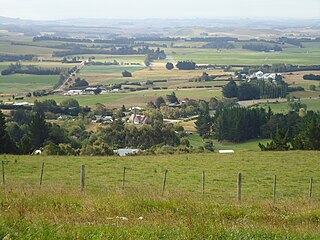
The Maniototo Plain, usually simply known as The Maniototo, is an elevated inland region in Otago, New Zealand. The region roughly surrounds the upper reaches of the Taieri River and the Manuherikia River. It is bounded by the Kakanui Range to the north and the Rock and Pillar Range to the southeast. It has a harsh, dry climate, ranging from over 30 °C in mid-summer to -15 °C in mid-winter.

<span class="mw-page-title-main">Roxburgh, New Zealand</span> Town in Otago, New Zealand

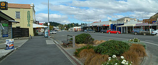
Roxburgh is a small New Zealand town of about 600 people in Central Otago. It is in Teviot Valley on the banks of the Clutha River, 40 kilometres (25 mi) south of Alexandra in the South Island. State Highway 8, which links Central Otago with Dunedin city, passes through the town. Roxburgh is well known for its Summer fruit and "Jimmy's Pies."

<span class="mw-page-title-main">Herbert, New Zealand</span> Rural settlement in Otago, New Zealand

The small town of Herbert, formerly Otepopo, lies in North Otago, New Zealand, 91 kilometres (57 mi) north of Dunedin and 22 kilometres (14 mi) south-west of Oamaru. It lies on the edge of the Herbert Forest.

<span class="mw-page-title-main">Omakau</span> Rural settlement in Otago, New Zealand

Omakau is a settlement in Central Otago, New Zealand, located between Alexandra and Ranfurly on the northwest bank of the Manuherikia River. The smaller settlement of Ophir, New Zealand is located on the opposite bank, three kilometres to the southeast.

<span class="mw-page-title-main">Clinton, New Zealand</span> Town in Otago, New Zealand

Clinton is a small town in South Otago, in New Zealand's South Island. Handy to the Catlins, Dunedin, Lawrence, Central Otago and Tapanui. It is located on State Highway 1 approximately halfway between Balclutha and Gore, and the Main South Line railway passes through the town.

<span class="mw-page-title-main">Wakatipu Basin</span>

The Wakatipu Basin is a plain surrounded by mountains in Queenstown Lakes District, in the southern South Island of New Zealand.

Waikaia, formerly known as Switzers, is a town in the Southland region of New Zealand's South Island. From 1909 until 1959, it was the terminus of the Waikaia Branch railway. The population in the 2013 census was 99, unchanged from the previous census in 2006.

<span class="mw-page-title-main">Gibbston</span> Community and wine region in Otago, New Zealand

Gibbston is a community in the Wakatipu Basin in the Otago region of the South Island, New Zealand. Through the valley runs the Kawarau River which forms the Kawarau Gorge.

<span class="mw-page-title-main">Shotover Country</span> Suburb in Queenstown, New Zealand

Shotover Country is a suburb of Queenstown in the South Island of New Zealand. It has around 810 sections and was originally 202 hectares when first rezoned from rural to residential. The suburb began in 2012 when sections first came up for sale. The postcode of Shotover Country is listed as Lower Shotover.

<span class="mw-page-title-main">Maraekakaho</span> Settlement in Hawkes Bay Region, New Zealand

Maraekakaho is a rural settlement in the Hastings District and Hawke's Bay Region of New Zealand's North Island.

Waimumu is a rural settlement town in the Gore District and Southland Region of New Zealand's South Island. It is located west of Gore, about 14 kilometres from the main township.

Gladstone is a suburb of New Zealand's southernmost city, Invercargill.

Prestonville is a suburb and industrial area in the New Zealand city of Invercargill.

Grasmere is a suburb in the New Zealand city of Invercargill.

Sunshine Bay is an inlet of Lake Wakatipu and suburb of Queenstown in the South Island of New Zealand. It is located on the lower slopes of the Ben Lomond mountain, west of Fernhill, on the northern side of the lake.

Harwood is a rural settlement on the northern side of the Otago Peninsula. It is within the boundaries of Dunedin city in New Zealand.

References

  1. 1 2 "ArcGIS Web Application". statsnz.maps.arcgis.com. Retrieved 6 December 2021.
  2. 1 2 "Population estimate tables - NZ.Stat". Statistics New Zealand . Retrieved 25 October 2023.
  3. Harriss, Gavin (July 2021). Earnscleugh, Otago (Map). NZ Topo Map.
  4. "Vineyard's appeal in case against driller fails". Allied Press. Otago Daily Times. 15 October 2020.
  5. "Pacific workers could be too late for Central Otago orchards". Allied Press. Otago Daily Times. 27 November 2020.
  6. 1 2 Morgan, Jared (23 January 2021). "Tractor operator dies after accident". Allied Press. Otago Daily Times.
  7. 1 2 3 4 "Earnscleugh Station History". earnscleughstation.co.nz. Earnscleugh Station.
  8. "Earnscleugh Tailings Track". doc.govt.nz. Department of Conservation.
  9. "Holidaymakers urged to check roads, growers count cost". Allied Press. Otago Daily Times. 3 January 2021.
  10. 1 2 "Statistical area 1 dataset for 2018 Census". Statistics New Zealand. March 2020. Earnscleugh (345200). 2018 Census place summary: Earnscleugh