Hampden, New Zealand

Last updated

Hampden
Rural settlement
On the beach at Hampden, New Zealand.jpg
The beach at Hampden looking south
Hampden, New Zealand
Coordinates: 45°19′40″S170°49′00″E / 45.32778°S 170.81667°E / -45.32778; 170.81667
Country New Zealand
Region Otago
Territorial authority Waitaki District
WardWaihemo Ward
Government
  Local authority Waitaki District Council
  Regional council Otago Regional Council
Area
[1]
  Total2.56 km2 (0.99 sq mi)
Population
 (2018 Census) [2]
  Total339
  Density130/km2 (340/sq mi)
Time zone UTC+12 (New Zealand Standard Time)
  Summer (DST) UTC+13 (New Zealand Daylight Time)
Postcode
9410

Hampden, a small town [3] in North Otago, New Zealand, lies close to the North Otago coast, 35 kilometres south of Oamaru and 80 kilometres north of the city of Dunedin, to both of which it is connected by State Highway 1.

Contents

The township's population at its largest was about 560, but by 2009 it had dwindled to approximately 230. [4] Hampden is named in honour of the English politician John Hampden by early surveyor W. B. D. Mantell, possibly influenced by the location of a public house, The Hampden Hotel, at the site. [5]

Geography

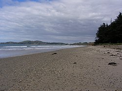
Hampden is situated beside a broad bay stretching from Aorere Point to Moeraki Point, on a coastal plain which rises westward to the foothills of the Horse Range and the Kakanui Range. The soil of this surrounding plain overlies a limestone formation. [6] The Moeraki Boulders are located two kilometres south of Hampden. [7] Much of the town lies between the Big Kuri (Kurinui) and Little Kuri Creeks.

The streets of Hampden run in a rectangular grid pattern centred on the main highway and the railway. They are named after English locations, such as Lancaster, Shrewsbury, Worcester, and Norfolk. There is surfing on the Kātiki straight, as well as trout-fishing in the Waianakarua and Shag Rivers.

History

The settlement was founded in the 1860s, with the first sale of land sections dated to March 1863. By 1865, there were two public houses in the area, The Hampden Hotel and The Clyde Hotel, and both a cemetery and mechanics' institute were in place by 1870. early industry in the area included the harvesting of flax and timber. [8]

A borough was proclaimed in 1879, with the first mayor being William Murcott. [8] The borough existed until the 1960s, and Hampden is now part of the Waitaki District. [4]

Demographics

Hampden is described as a rural settlement by Statistics New Zealand, and covers 2.56 km2 (0.99 sq mi). [1] It is part of the larger Waihemo statistical area. [9]

Historical population
YearPop.±% p.a.
2006297    
2013303+0.29%
2018339+2.27%
Source: [2]

Hampden had a population of 339 at the 2018 New Zealand census, an increase of 36 people (11.9%) since the 2013 census, and an increase of 42 people (14.1%) since the 2006 census. There were 156 households. There were 156 males and 177 females, giving a sex ratio of 0.88 males per female, with 48 people (14.2%) aged under 15 years, 30 (8.8%) aged 15 to 29, 168 (49.6%) aged 30 to 64, and 90 (26.5%) aged 65 or older.

Ethnicities were 86.7% European/Pākehā, 15.9% Māori, 1.8% Pacific peoples, and 2.7% Asian (totals add to more than 100% since people could identify with multiple ethnicities).

Although some people objected to giving their religion, 54.9% had no religion, 34.5% were Christian, 0.9% were Hindu and 1.8% had other religions.

Of those at least 15 years old, 30 (10.3%) people had a bachelor or higher degree, and 81 (27.8%) people had no formal qualifications. The employment status of those at least 15 was that 111 (38.1%) people were employed full-time, 48 (16.5%) were part-time, and 6 (2.1%) were unemployed. [2]

Church

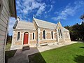
The Hampden Presbyterian church was built in 1870 and was no longer used for regular services in 2010 due to a declining number of parishioners. [10] The church has seating for almost 200 parishioners. [11] It was designed by the architect RA Lawson in 1869. [12]

Modern Hampden

The town includes a rural fire station, a fish-and-chip shop, a small supermarket, a motel, and backpackers, a popular camping ground, a cafe, mechanics workshop, a small second-hand goods shop, a tavern, and a historic town hall. Sheep farming is the primary economic activity of the region and is augmented by farming of other livestock.

The Hampden Energy Forum, established in 2007, has grown into a community self-help scheme that involves nearly everyone in the settlement, growing from a small group of enthusiasts who were concerned about the future of small rural communities in "post-oil" days. At the inaugural meeting to establish the Forum, more than one third of the town's population attended. The forum won the Trustpower Community Award in 2008.

Education

Hampden School is a full primary school catering for years 1 to 8, [13] with a roll of 43 students as of April 2023. [14] The school opened in 1864. [15]

Notable people

Related Research Articles

<span class="mw-page-title-main">Otago</span> Region of New Zealand

Otago is a region of New Zealand located in the southern half of the South Island administered by the Otago Regional Council. It has an area of approximately 32,000 square kilometres (12,000 sq mi), making it the country's second largest local government region. Its population was 254,600 in June 2023.

<span class="mw-page-title-main">Queenstown, New Zealand</span> Resort town in New Zealands South Island

Queenstown is a resort town in Otago in the south-west of New Zealand's South Island. It has an urban population of 29,000.

<span class="mw-page-title-main">Gore, New Zealand</span> Town in Southland, New Zealand

Gore is a town and district in the Southland region of the South Island of New Zealand. It has a resident population of around 8,000 people. Gore is known for its country music scene and hosts an annual country music festival. The town is also surrounded by farmland and is an important centre for agriculture in the region.

<span class="mw-page-title-main">Cromwell, New Zealand</span> Town in Otago, New Zealand

Cromwell is a town in Central Otago region of the South Island of New Zealand. Cromwell is located on the shores of Lake Dunstan where the Kawarau river joins Lake Dunstan. Cromwell was established during the Otago gold rush and is now more known as one of the sub regions of the Central Otago wine region. In 2018, the town of Cromwell was home to a population of 5610 people.

<span class="mw-page-title-main">Waitaki District</span> Territorial authority district in New Zealand

Waitaki District is a territorial authority district that is located in the Canterbury and Otago regions of the South Island of New Zealand. It straddles the traditional border between the two regions, the Waitaki River, and its seat is Oamaru.

<span class="mw-page-title-main">Lawrence, New Zealand</span> Town in Otago, New Zealand

Lawrence is a small town in Otago, in New Zealand's South Island. It is located on State Highway 8, the main route from Dunedin to the inland towns of Queenstown and Alexandra. It lies 35 kilometres to the northwest of Milton, 11 kilometres northwest of Waitahuna, and close to the Tuapeka River, a tributary of the Clutha.

<span class="mw-page-title-main">Brighton, New Zealand</span> Settlement in New Zealand

Brighton is a small seaside town within the city limits of Dunedin on New Zealand's South Island. It is located 20 kilometres southwest from the city centre on the Southern Scenic Route. The town faces a small bay which includes a broad sheltered beach. Other beaches extend from here. They make the area popular for summer day trips from Dunedin.

<span class="mw-page-title-main">Palmerston, New Zealand</span> Town in Otago, New Zealand

The town of Palmerston, in New Zealand's South Island, lies 50 kilometres to the north of the city of Dunedin. It is the largest town in the Waihemo Ward of the Waitaki District, with a population of 890 residents. Palmerston grew at a major road junction: State Highway 1 links Dunedin and Waikouaiti to the south with Oamaru and Christchurch to the north, while State Highway 85 heads inland to become the principal highway of the Maniototo. The Main South Line railway passes through the town and the Seasider tourist train travels from Dunedin to Palmerston and back once or twice a week. From 1880 until 1989, the town acted as the junction between the main line and a branch line that ran inland, the Dunback and Makareao Branches.

<span class="mw-page-title-main">Herbert, New Zealand</span> Rural settlement in Otago, New Zealand

The small town of Herbert, formerly Otepopo, lies in North Otago, New Zealand, 91 kilometres (57 mi) north of Dunedin and 22 kilometres (14 mi) south-west of Oamaru. It lies on the edge of the Herbert Forest.

<span class="mw-page-title-main">Temuka</span> Town in Canterbury, New Zealand

Temuka is a town on New Zealand's Canterbury Plains, 15 kilometres north of Timaru and 142 km south of Christchurch. It is located at the centre of a rich sheep and dairy farming region, for which it is a service town. It lies on the north bank of the Temuka River, just above its confluence with the Opihi River.

<span class="mw-page-title-main">Outram, New Zealand</span> Town in the South Island of New Zealand

Outram is a rural suburb of Dunedin, New Zealand, with a population of 642. It is located 28 kilometres west of the central city at the edge of the Taieri Plains, close to the foot of Maungatua. The Taieri River flows close to the southeast of the town. Outram lies on State Highway 87 between Mosgiel and Middlemarch.

<span class="mw-page-title-main">Moeraki</span> Village in Otago, New Zealand

Moeraki is a small fishing village on the east coast of the South Island of New Zealand. It was once the location of a whaling station. In the 1870s, local interests believed it could become the main port for the north Otago area and a railway line, the Moeraki Branch, was built to the settlement and opened in 1877. However, the port could not compete with Oamaru and the lack of traffic as well as stability problems caused by difficult terrain led to the closure of the railway in 1879 after only two years' operation.

<span class="mw-page-title-main">Owaka</span> Place in Otago, New Zealand

Owaka is a small town in the Clutha District of South Otago, in the South Island of New Zealand. It is the largest community in the rugged, forested Catlins area, close to the border with Southland, some 35 km (22 mi) south of Balclutha on the Southern Scenic Route.

Balfour is a small town located in the Southland region of New Zealand.

<span class="mw-page-title-main">Dunback</span> Town in Otago, New Zealand

Dunback, formerly Waihemo, is a small town in the Otago region of New Zealand. It is located between Palmerston and Ranfurly on Highway 85. It has a population of about 200 people. Most of these people live in the rural areas near the town.

<span class="mw-page-title-main">Clinton, New Zealand</span> Town in Otago, New Zealand

Clinton is a small town in South Otago, in New Zealand's South Island. Handy to the Catlins, Dunedin, Lawrence, Central Otago and Tapanui. It is located on State Highway 1 approximately halfway between Balclutha and Gore, and the Main South Line railway passes through the town.

Edendale is a town in the Southland region of New Zealand's South Island. The township is situated on the Southland Plains just to the west of the Mataura River. Before the town was called Edendale, it was known by the names Maorirua, Mataura Plains and Stuart's Bush.

Kātiki is a small settlement in North Otago, New Zealand. It lies between the townships of Palmerston and Hampden on State Highway 1 at the northern end of Kātiki Beach, close to the Moeraki Peninsula. The tip of the peninsula, Kātiki Point, is the site of Kātiki Point Lighthouse. The scenic reserve of Trotter's Gorge is located just inland of Kātiki.

<span class="mw-page-title-main">City Rise</span> Suburb of Dunedin, New Zealand

City Rise is an inner suburb of the New Zealand city of Dunedin. One of the city's older suburbs, it is, as its name suggests, centred on the slopes which lie close to the city centre, particularly those closest to the city's original heart of The Exchange. Extensive views across the central city can be gained from much of City Rise.

Waihemo is a former parliamentary electorate in the Otago region of New Zealand. It existed for two periods and was represented by two Members of Parliament.

References

  1. 1 2 "ArcGIS Web Application". statsnz.maps.arcgis.com. Retrieved 28 November 2021.
  2. 1 2 3 "Statistical area 1 dataset for 2018 Census". Statistics New Zealand. March 2020. 7027746 and 7027747.
  3. "Place name detail: Hampden". New Zealand Gazetteer. New Zealand Geographic Board . Retrieved 29 May 2007.
  4. 1 2 Rae, S. "Hampden set to mark 130 years as township," Otago Daily Times , 22 October 2009. Retrieved 20 April 2018.
  5. Reed, A.W. (1975) Place names of New Zealand. Wellington: A.H. & A.W. Reed. p.159
  6. Davis, Brian N.; Dollimore, Edward S. "Hampden". Te Ara – the encyclopedia of New Zealand (1966). Retrieved 20 April 2018.
  7. Peter Dowling, ed. (2004). Reed New Zealand Atlas. Reed Books. pp. map 102. ISBN   0-7900-0952-8.
  8. 1 2 Moore, C.W.S., (1958) Northern Approaches. Christchuch: Whitcombe & Tombs. pp. 115–6
  9. 2018 Census place summary: Waihemo
  10. Bruce, David (10 August 2010). "Future of church to be discussed". Otago Daily Times Online News. Retrieved 4 May 2023.
  11. "The Hampden Presbyterian Church | NZETC". nzetc.victoria.ac.nz. Retrieved 4 May 2023.
  12. Campbell, Bill (26 January 2011). "Uses sought for church". Otago Daily Times Online News. Retrieved 4 May 2023.
  13. Education Counts: Hampden School
  14. "New Zealand Schools Directory". New Zealand Ministry of Education. Retrieved 12 December 2022.
  15. Campbell, Bill (4 June 2014). "School reopened". Otago Daily Times.