Related Research Articles

The Clutha River / Mata-Au, also known as the Clutha River, is the second longest river in New Zealand and the longest in the South Island. It flows south-southeast 338 kilometres (210 mi) through Central and South Otago from Lake Wānaka in the Southern Alps / Kā Tiritiri o te Moana to the Pacific Ocean, 75 kilometres (47 mi) south west of Dunedin. It is the highest volume river in New Zealand, and the swiftest, with a catchment of 21,960 square kilometres (8,480 sq mi), discharging a mean flow of 614 cubic metres per second (21,700 cu ft/s). The river is known for its scenery, gold-rush history, and swift turquoise waters. A river conservation group, the Clutha Mata-Au River Parkway Group, is working to establish a regional river parkway, with a trail, along the entire river corridor.

North Otago in New Zealand covers the area of Otago between Shag Point and the Waitaki River, and extends inland to the west as far as the village of Omarama.

The Taieri River is the fourth-longest river in New Zealand and is in Otago in the South Island. Rising in the Lammerlaw Range, it initially flows north, then east around the Rock and Pillar range before turning southeast, reaching the sea 30 kilometres (19 mi) south of Dunedin.
The Taieri Plain is an area of fertile agricultural land to the southwest of Dunedin, in Otago, New Zealand. The plain covers an area of some 300 square kilometres, with a maximum extent of 30 kilometres. It is not to be confused with Strath Taieri, a second plain of the Taieri River, 40kms to the north beyond Mount Ross.

The Waipori River is in Otago in the South Island of New Zealand. Rising in the Lammerlaw Range, it flows southeast for 50 kilometres (31 mi) before joining the Taieri River near Henley, 30 kilometres (19 mi) southwest of Dunedin of which it is officially the southernmost border. Google Maps erroneously shows the stretch of Taieri river from the confluence to the mouth as Waipori River. The correct name is shown on the New Zealand government's official NZ Topo Map.

Hampden, a small town in North Otago, New Zealand, lies close to the North Otago coast, 35 kilometres south of Oamaru and 80 kilometres north of the city of Dunedin, to both of which it is connected by State Highway 1.

The Silverpeaks is an area of rough forest and tussock and scrub covered hill country inland and to the northwest of Dunedin, New Zealand. The area is largely uninhabited; the main indication of human activity is the Taieri Gorge Railway, which preserves the route of the former Otago Central Railway that runs along the steep-sided valley of the Taieri River. Much of the area lies within the Silverpeaks Scenic Reserve.

The Ōtaki River is in the southwestern North Island of New Zealand. It originates in the Tararua Range and flows for 45 kilometres (28 mi), heading southwest through a valley in the Tararua Ranges. It turns northwest in the area of Ōtaki Forks, where it is joined by the Waiotauru River. After continuing through Otaki Gorge towards Kapiti Coast, it crosses State Highway 1 (SH1) south of Ōtaki and reaches the Tasman Sea south of the settlement of Ōtaki Beach.

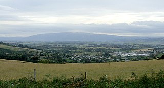
The small town of Kakanui lies on the coast of Otago, in New Zealand, fourteen kilometres to the south of Oamaru. The Kakanui River and its estuary divide the township in two. The part of the settlement south of the river, also known as Kakanui South, formerly "Campbells Bay", was developed as a collection of cribs. A recent increase in the development of subdivisions has increased the density of dwellings within South Kakanui.

The Kakanui Range is a range of high hills located inland from Oamaru in the South Island of New Zealand. The range forms a boundary between the valley of the Waitaki River to the north and the high plateau known as the Maniototo and the upper watershed of the Taieri River to the southwest. The highest point in the Kakanui Range is Mount Pisgah, at 1643 m (5394 ft).

Kelso is an abandoned small settlement in Otago, New Zealand, located ten kilometres north of Tapanui on the Crookston Burn, close to its junction with the larger Pomahaka River. Its population during the 1960s and 1970s was close to 300, with most of its economy based on sheep farming. A small dairy factory was a focal point in the village's early years.

State Highway 85 (SH 85) is a South Island state highway in New Zealand, servicing the Maniototo Plains and the North and Central Otago regions of the South Island between the major settlements of Alexandra and Palmerston. It is wholly two lane and passes through some of the most extreme climatic regions in New Zealand. The highway is known colloquially as "The Pigroot". Though there is no definitive explanation for this name, A. W. Reed, in his book Place Names of New Zealand, mentions an incident during John Turnbull Thomson's survey of inland Otago in which local wild pigs were so unafraid of humans that a huge boar approached his party and rubbed its nose against that of Thomson's horse.

The Ashburton River / Hakatere is a river in the Canterbury region of New Zealand, flowing across Mid Canterbury from the Southern Alps to the Pacific Ocean. The official name of the river was amended to become a dual name by the Ngāi Tahu Claims Settlement Act 1998. It has been identified as an Important Bird Area by BirdLife International because it supports breeding colonies of the endangered black-billed gull.
Kia Ora is a small dairy farming locality in North Otago, centred on Kia Ora Hall. It is located 10 kilometres west of Oamaru and a similar distance north of Maheno. The nearest watercourse is Robbs Crossing River, a small tributary of the Kakanui River.
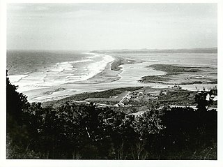
Ōkārito is a small coastal settlement on the West Coast of New Zealand's South Island, 127 kilometres (79 mi) southwest of Hokitika, and 10 kilometres (6.2 mi) from State Highway 6. It is built at the southern end of the Ōkārito Lagoon at the mouth of the Ōkārito River. The settlement of The Forks is located just inland, on the banks of the river.
Kyeburn is a small settlement in Otago, in the South Island of New Zealand. It lies on the Maniototo, a wide, high plain stretching from the end of the Strath-Taieri valley.

The Humboldt Mountains or Humboldt Range are one of the many ranges which make up the Southern Alps in the South Island of New Zealand. They lie to the northwest of Lake Wakatipu in the Otago Region. Parts of the range lie within Fiordland National Park, and they form the southern extremity of Mount Aspiring National Park. The range was named by early explorer James McKerrow, and like many geographic features worldwide, it was named in honour of notable scientist Alexander von Humboldt.
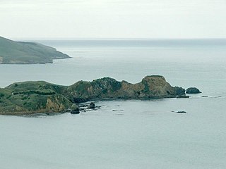
Huriawa, commonly known as Huriawa Peninsula or Karitane Peninsula, is a headland on the coast of Otago, New Zealand. It is located 35 kilometres north of Dunedin city centre, immediately to the southeast of the settlement of Karitane.
Oaro is a settlement close to the Pacific Ocean Coast of north Canterbury, in the South Island of New Zealand.

The Two Thumb Range is a range of mountains in the Canterbury Region of New Zealand's South Island. It is located to the east of Lake Tekapo and has several peaks which rise to around 2,500 metres (8,200 ft). The southern end of the range contains one of Canterbury's main skifields, Mount Dobson.
References
- ↑ Dowling, P. (ed.) (2004). ’’Reed New Zealand atlas’’. Auckland: Reed Publishing. Map 102. ISBN 0 7900 0952 8
- ↑ Reed, A.W. (1975). Place names of New Zealand. Wellington: A.H. & A.W. Reed. p. 256.
- ↑ Rae, Sally "Five Forks residents plan 100-year party," Otago Daily Times , 5 January 2011. Retrieved 29 May 2020.
Coordinates: 45°02′S170°45′E / 45.033°S 170.750°E
| | This Otago geography article is a stub. You can help Wikipedia by expanding it. |