Katiki

Last updated

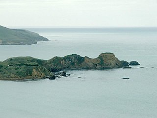
Katiki is a small settlement in North Otago, New Zealand. It lies between the townships of Palmerston and Hampden on State Highway 1 at the northern end of Katiki Beach, close to the Moeraki Peninsula. The tip of the peninsula, Katiki Point, is the site of Katiki Point Lighthouse. The scenic reserve of Trotter's Gorge is located just inland of Katiki.

North Otago

The district of North Otago in New Zealand covers the area of Otago between Shag Point and the Waitaki River, and extends inland to the west as far as the village of Omarama.

Palmerston, New Zealand Town in Otago, New Zealand

The town of Palmerston, in New Zealand's South Island, lies 50 kilometres to the north of the city of Dunedin. It is the largest town in the Waihemo Ward of the Waitaki District, with a population of 890 residents. Palmerston grew at a major road junction: State Highway 1 links Dunedin and Waikouaiti to the south with Oamaru and Christchurch to the north, while State Highway 85 heads inland to become the principal highway of the Maniototo. The Main South Line railway passes through the town and the Seasider tourist train travels from Dunedin to Palmerston and back once or twice a week. From 1880 until 1989, the town acted as the junction between the main line and a branch line that ran inland, the Dunback and Makareao Branches.

Hampden, New Zealand human settlement in New Zealand

Hampden, a rural township in North Otago, New Zealand, lies close to the North Otago coast, 35 kilometres south of Oamaru and 80 kilometres north of the city of Dunedin, to both of which it is connected by State Highway 1.

There is uncertainty about the origin of the name, though it could have originally been Ka tiki ("The carved figures"). The settlement was called Kartigi until 1927, this former name stressing the local Southern Māori pronunciation. The town no longer has any signage but for a small bridge sign 'Katiki bridge'. Further north along the coast from the lighthouse are two small settlements called the Katiki Kaiks ("kaik" is the Southern Maori version of the term kainga, meaning village). The houses at the kaiks are very basic and predominantly cribs (holiday homes). Property is difficult to attain there as it cannot be purchased, only leased.

Māori language Polynesian language spoken by New Zealand Māori

Māori, also known as te reo, is an Eastern Polynesian language spoken by the Māori people, the indigenous population of New Zealand. Closely related to Cook Islands Māori, Tuamotuan, and Tahitian, it gained recognition as one of New Zealand's official languages in 1987. The number of speakers of the language has declined sharply since 1945, but a Māori language revitalisation effort slowed the decline, and the language has experienced a revival, particularly since about 2015.

Katiki lighthouse is home to yellow-eyed penguins (hoiho), one of the rarest species of penguin in the world. Its visitors can almost be guaranteed to see fur seals on their visit to the viewing huts. The area is also a local fishing spot, especially for blue cod.

Yellow-eyed penguin species of bird

The yellow-eyed penguin or hoiho is a penguin native to New Zealand. Previously thought closely related to the little penguin, molecular research has shown it more closely related to penguins of the genus Eudyptes. Like most other penguins, it is mainly piscivorous.

Blue cod species of fish

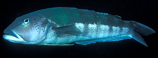
The blue cod is a temperate marine fish of the family Pinguipedidae. It is also known variously as Boston blue cod, New Zealand cod, sand perch, or its Māori names rāwaru, pākirikiri and patutuki.

Related Research Articles

Otago Peninsula peninsula

The Otago Peninsula is a long, hilly indented finger of land that forms the easternmost part of Dunedin, New Zealand. Volcanic in origin, it forms one wall of the eroded valley that now forms Otago Harbour. The peninsula lies south-east of Otago Harbour and runs parallel to the mainland for 20 km, with a maximum width of 9 km. It is joined to the mainland at the south-west end by a narrow isthmus about 1.5 km wide.

Port Chalmers Human settlement in New Zealand

Port Chalmers is a suburb and the main port of the city of Dunedin, New Zealand, with a population of 3,000. Port Chalmers lies ten kilometres inside Otago Harbour, some 15 kilometres northeast from Dunedin's city centre.

Otakou Place in Otago, New Zealand

Otakou is a settlement within the boundaries of the city of Dunedin, New Zealand. It is located 25 kilometres from the city centre at the eastern end of Otago Peninsula, close to the entrance of Otago Harbour. The settlement is the modern center and traditional home of the Ōtākou runanga of Ngai Tahu. In 1946 Otakou Fisheries was started based out of the township, this was later to become a major part of the Otago fishing industry.

Aramoana human settlement

Aramoana is a small coastal settlement, 27 kilometres north of Dunedin city, in the South Island of New Zealand. The settlement's permanent population in 2001 Census was 261. Supplementing this are seasonal visitors from the city who occupy cribs. The name Aramoana is Maori for "pathway of the sea".

Macandrew Bay human settlement in New Zealand

Macandrew Bay is located on the Otago Peninsula in the South Island of New Zealand. It is situated on the edge of Otago Harbour, and is named for pioneer settler James Macandrew who lived here during his later life. Early residents of the area called the bay "The Hundreds", due to the large number of boulders which covered the foreshore.

Moeraki Village in Otago, New Zealand

Moeraki is a small fishing village on the east coast of the South Island of New Zealand. It was once the location of a whaling station. In the 1870s, local interests believed it could become the main port for the north Otago area and a railway line, the Moeraki Branch, was built to the settlement and opened in 1877. However, the port could not compete with Oamaru and the lack of traffic as well as stability problems caused by difficult terrain led to the closure of the railway in 1879 after only two years of operation.

Taiaroa Head

Taiaroa Head is a headland at the end of the Otago Peninsula in New Zealand, overlooking the mouth of the Otago Harbour. It lies within the city limits of Dunedin. The nearest settlement, Otakou, lies three kilometres to the south.

Katiki Point Lighthouse lighthouse in New Zealand

The Katiki Point Lighthouse, also known as Moeraki Lighthouse, shone for the first time in 1878, following several accidents on the dangerous reefs around the area, to make the area safer for ships that sailed past on their way to Port Chalmers, Dunedin. The lighthouse was built between the settlements of Moeraki and Katiki, on the tip of the Moeraki Peninsula, which is known as Katiki Point or Moeraki Point.

St Leonards, Dunedin Suburb of the New Zealand city of Dunedin

St Leonards is a suburb of the New Zealand city of Dunedin. It is located close to the northern shore of the Otago Harbour and on the hilly slopes above the harbour. St Leonards is 8.5 kilometres (5.3 mi) northeast of Dunedin's city centre, between the small settlement of Burkes and Sawyers Bay. St Leonards was named by early settler David Carey for the birthplace of his wife, the English town of St Leonards-on-Sea, on the Sussex coast.

Ocean Grove, New Zealand human settlement in New Zealand

Ocean Grove, also known as Tomahawk, is a suburb in the southeast of the New Zealand city of Dunedin. A semi-rural residential suburb on the Pacific coast at the southwestern end of the Otago Peninsula, Ocean Grove is located 6.5 kilometres (4.0 mi) southeast of Dunedin city centre.

Ravensbourne, New Zealand

Ravensbourne is a suburb of the New Zealand city of Dunedin. It is located on the steep southeastern slopes of Signal Hill above the Otago Harbour. It lies on the harbour's northern shore, 4.5 kilometres (2.8 mi) east-northeast of the city centre. Ravensbourne's 2001 population was 1,269.

Victory Beach

Victory Beach is located on the Pacific Ocean coast of the Otago Peninsula, in the South Island of New Zealand, 24 kilometres (15 mi) by road from Dunedin city centre. The longest beach on the peninsula, Victory Beach is located northeast of the entrance to Papanui Inlet and stretches for 3.5 kilometres. It is backed by a series of high sand dunes. The beach's name derives from the wreck of the SS Victory on the beach in 1861. The beach and headlands to the north and south form Wickliffe Bay, itself named for the ship John Wickliffe, which – along with the Philip Laing – brought the first permanent European settlers to Otago.

Kensington, New Zealand suburb in Otago Region, New Zealand

Kensington is a small suburb of the New Zealand city of Dunedin, nestled to the south of a hilly spur between the central city and the major suburb of South Dunedin, some 2.4 kilometres (1.5 mi) to the south of the city centre. The suburb was named for the leafy London suburb, possibly by John Hyde Harris, who subdivided the area in the 1860s.

Glenledi, also known as Bull Creek, is a small coastal farming and holiday settlement to the east of Milton, New Zealand, in the Otago region of New Zealand's South Island. It lies at the north end of Chrystall's Beach, six kilometres northeast along the coast from Toko Mouth. The small Glenledi Stream enters the Pacific Ocean at Bull Creek, passing through a reef-protected cove surrounded by native bush.

Waiwera South is a small settlement in the South Island of New Zealand, close to the boundary between the Otago and Southland regions. The settlement is located between Balclutha and Clinton, immediately to the south of State Highway 1, between branches of the Waiwera River and Kaihiku Stream, two minor tributaries of the Clutha River. The South Island Main Trunk railway also runs through the township. The settlement's population is around 100.

Papanui Inlet

Papanui Inlet is the northernmost of two large inlets in the Pacific coast of Otago Peninsula, in the South Island of New Zealand.

Hoopers Inlet bight in New Zealand

Hoopers Inlet is one of two large inlets in the Pacific coast of Otago Peninsula, in the South Island of New Zealand.

Huriawa Peninsula

Huriawa, commonly known as Huriawa Peninsula or Karitane Peninsula, is a headland on the coast of Otago, New Zealand. It is located 35 kilometres north of Dunedin city centre, immediately to the southeast of the settlement of Karitane.

Otago Heads

The Otago Heads is the historic name given to the headlands and coastal settlements close to the mouth of the long drowned volcanic rift which forms the Otago Harbour, in the South Island of New Zealand.

References

Coordinates: 45°23′46″S170°50′22″E / 45.396137°S 170.839409°E / -45.396137; 170.839409

Geographic coordinate system Coordinate system

A geographic coordinate system is a coordinate system that enables every location on Earth to be specified by a set of numbers, letters or symbols. The coordinates are often chosen such that one of the numbers represents a vertical position and two or three of the numbers represent a horizontal position; alternatively, a geographic position may be expressed in a combined three-dimensional Cartesian vector. A common choice of coordinates is latitude, longitude and elevation. To specify a location on a plane requires a map projection.