Related Research Articles
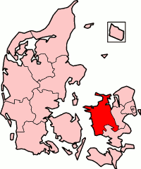
West Zealand County is a former county in the west-central part of the island of Zealand (Sjælland) in eastern Denmark. The county was formed on 1 April 1970, comprising a few former counties. The county was abolished effective January 1, 2007, when it merged into Region Sjælland.

Moturoa / Rabbit Island is a small island that lies across the southernmost part of Tasman Bay / Te Tai-o-Aorere, on the northern coast of New Zealand's South Island. The long narrow island runs east–west for 8 kilometres (5 mi), and covers 15 km2 (5.8 sq mi).
The Supporters Range is a rugged range in the Queen Maud Mountains of Antarctica. It is 25 nautical miles long, bordering the eastern side of Mill Glacier, from Keltie Glacier in the north to Mill Stream Glacier in the south. So named by the New Zealand Geological Survey Antarctic Expedition (NZGSAE) (1961–62) because several peaks of the range are named after supporters of Ernest Shackleton's British Antarctic Expedition (1907–09).

The Wright Valley is a large east–west trending valley, formerly occupied by a glacier but now ice free except for Wright Upper Glacier at its head and Wright Lower Glacier at its mouth, in Victoria Land, Antarctica. It was named by the VUWAE (1958-59) for Sir Charles Wright, for whom the BrAE (1910-13) named the glacier at the mouth of this valley.
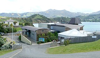
The Portobello Marine Laboratory is located on the end of a short peninsula close to the township of Portobello, within the limits of the city of Dunedin in New Zealand's South Island. It is run as part of the University of Otago, the main campus of which is 23 kilometres to the southwest in Dunedin's main urban area.
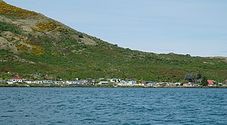
The settlement of Harington Point lies within the boundaries of the city of Dunedin, New Zealand. It is located at the Otago Heads, at the northeastern end of Otago Peninsula, close to the entrance of Otago Harbour. The mouth of the harbour is at its narrowest at Harington Point, only some 400 metres separating the point from the mudflats at Aramoana on the opposing coast.
Glenpark is a lightly populated rural locality in the Otago region of New Zealand's South Island. It is northwest of Palmerston and is on the banks of the Shag River. To the west is the locality of Stoneburn.

Pukehiki is a small locality on the Otago Peninsula, within the city of Dunedin on the South Island of New Zealand. It is located on the ridge which runs along the centre of the peninsula, 8 kilometres (5.0 mi) from Dunedin city centre, at a junction between Highcliff Road, which runs along the peninsula's ridge, and Castlewood Road, which descends to Company Bay on the shore of the Otago Harbour.
The Lambert River is a river of the West Coast Region of New Zealand's South Island. It flows north from the Lambert Glacier in the Southern Alps, joining with the Wanganui River 15 kilometres (9 mi) southeast of Harihari.
The Te Rahotaiepa River is a river of the West Coast Region of New Zealand's South Island. It rises to the north of Lake Ianthe and flows parallel with the Tasman Sea coast along the edge of marshy ground for several kilometres to flow into the mouth of the Waitaha River.
Molar Massif is a large mountain massif immediately east of the Lanterman Range in the Bowers Mountains of Antarctica. It was mapped by the United States Geological Survey (USGS) from ground surveys and United States Navy air photos, 1960–1964. The descriptive name was applied by the United States Advisory Committee on Antarctic Names (US-ACAN) because, when viewed in plan, the outline of the massif resembles a molar tooth.
The Gallipoli Heights are a group of peaks and ridges centered 7.5 nautical miles south-southeast of Monte Cassino, in the Freyberg Mountains of Victoria Land, Antarctica. They were named in association with Lord Freyberg and the nearby Freyberg Mountains by the Northern Party of the New Zealand Geological Survey Antarctic Expedition (NZGSAE), 1963–64.
Slagle Ridge is a high and massive snow-covered ridge between Slone Glacier and Burnette Glacier in the Admiralty Mountains, Victoria Land, Antarctica.
Cape Lyttelton is a cape forming the southern entrance point of Shackleton Inlet, along the western edge of the Ross Ice Shelf, Antarctica.

Dunedin Gasworks Museum is located in South Dunedin, in the South Island of New Zealand. It is one of only a few known preserved gasworks museums in the world.

Robert Burns is a bronze portrait statue of Robert Burns by John Steell. Four versions exist, in New York City, Dundee (Scotland), London (England), and Dunedin.

The Southern District Health Board was a district health board which provided healthcare to an area covering the southern half of the South Island of New Zealand. In July 2022, the Southern DHB was dissolved as part of a nationwide overhaul of the district health board system. Its former functions and responsibilities were taken over by Te Whatu Ora.
Wairunga is a locality in Otago, New Zealand. It is located on SH1 to the south of Palmerston. The Pleasant River flows immediately to the west of Wairunga.
References
- ↑ "Place name detail: Stoneburn". New Zealand Gazetteer. New Zealand Geographic Board . Retrieved 17 March 2018.
45°26′S170°34′E / 45.433°S 170.567°E
| | This Otago geography article is a stub. You can help Wikipedia by expanding it. |