Maheno, New Zealand

Last updated

Maheno
Rural settlement
Maheno - 7158830445.jpg
Maheno war memorial
Maheno, New Zealand
Coordinates: 45°10′S170°50′E / 45.167°S 170.833°E / -45.167; 170.833 Coordinates: 45°10′S170°50′E / 45.167°S 170.833°E / -45.167; 170.833
CountryNew Zealand
Region Otago
Territorial authority Waitaki District
WardCorriedale Ward
Government
  Local authority Waitaki District Council
  Regional council Otago Regional Council
Area
[1]
  Total0.56 km2 (0.22 sq mi)
Population
 (2018 Census) [2]
  Total126
  Density230/km2 (580/sq mi)
Local iwi Ngāi Tahu

Maheno is a small North Otago township south of Oamaru in New Zealand. The area has 75 residents. A number of the town's streets are named after places in Tyne and Wear, England, such as Whickham, Felling, Heworth and Jarrow. One of two New Zealand's hospital ships in World War I, the SS Maheno, was named after this town. [3]

Contents

Demographics

Maheno is described as a rural settlement by Statistics New Zealand, and covers 0.56 km2 (0.22 sq mi). [1] It is part of a larger statistical area also called Maheno.

Historical population for Maheno settlement
YearPop.±% p.a.
2006144    
2013108−4.03%
2018126+3.13%
Source: [2]

Maheno settlement had a population of 126 at the 2018 New Zealand census, an increase of 18 people (16.7%) since the 2013 census, and a decrease of 18 people (−12.5%) since the 2006 census. There were 54 households. There were 66 males and 60 females, giving a sex ratio of 1.1 males per female. The median age was 54.7 years (compared with 37.4 years nationally), with 12 people (9.5%) aged under 15 years, 21 (16.7%) aged 15 to 29, 63 (50.0%) aged 30 to 64, and 30 (23.8%) aged 65 or older.

Ethnicities were 92.9% European/Pākehā, 7.1% Māori, and 2.4% other ethnicities (totals add to more than 100% since people could identify with multiple ethnicities).

Although some people objected to giving their religion, 52.4% had no religion, and 35.7% were Christian.

Of those at least 15 years old, 9 (7.9%) people had a bachelor or higher degree, and 33 (28.9%) people had no formal qualifications. The median income was $22,200, compared with $31,800 nationally. The employment status of those at least 15 was that 51 (44.7%) people were employed full-time, 21 (18.4%) were part-time, and 3 (2.6%) were unemployed. [2]

Maheno statistical area

Maheno statistical area, which also includes Kakanui and Herbert, covers 262.41 km2 (101.32 sq mi) [1] and had an estimated population of 2,100 as of June 2021, [4] with a population density of 8 people per km2.

Historical population for Maheno statistical area
YearPop.±% p.a.
20061,875    
20131,818−0.44%
20181,968+1.60%
Source: [5]

Maheno had a population of 1,968 at the 2018 New Zealand census, an increase of 150 people (8.3%) since the 2013 census, and an increase of 93 people (5.0%) since the 2006 census. There were 789 households. There were 984 males and 984 females, giving a sex ratio of 1.0 males per female. The median age was 49.8 years (compared with 37.4 years nationally), with 342 people (17.4%) aged under 15 years, 216 (11.0%) aged 15 to 29, 978 (49.7%) aged 30 to 64, and 426 (21.6%) aged 65 or older.

Ethnicities were 94.4% European/Pākehā, 6.6% Māori, 0.9% Pacific peoples, 2.7% Asian, and 1.4% other ethnicities (totals add to more than 100% since people could identify with multiple ethnicities).

The proportion of people born overseas was 11.6%, compared with 27.1% nationally.

Although some people objected to giving their religion, 53.7% had no religion, 37.3% were Christian, 0.2% were Muslim, 0.5% were Buddhist and 1.5% had other religions.

Of those at least 15 years old, 276 (17.0%) people had a bachelor or higher degree, and 369 (22.7%) people had no formal qualifications. The median income was $27,800, compared with $31,800 nationally. 231 people (14.2%) earned over $70,000 compared to 17.2% nationally. The employment status of those at least 15 was that 786 (48.3%) people were employed full-time, 288 (17.7%) were part-time, and 33 (2.0%) were unemployed. [5]

St Andrew's Maheno

St Andrew's Church in Maheno St Andrew's Church, Maheno.jpg
St Andrew's Church in Maheno

St Andrew's Church in Maheno is part of the Anglican Parish of Oamaru-Maheno. Services are held every Sunday at 9am, apart from in January.

Maheno rugby

Maheno
Club information
Full nameMaheno Rugby Football Club
ColoursGreen and Black
Founded1898
WebsiteNo current website
Current details
Ground(s)
  • Maheno Domain
CompetitionCitizens Shield

The Maheno Rugby Football Club play their home games at the Maheno Domain. The Maheno domain is situated along Kakanui Valley road, in Maheno.

Maheno School

Maheno School is a full primary which caters for years 1 to 8 [6] with a roll of 54 as of November 2021. [7]

Maheno School opened on 11 October 1875, [8] to the delight of many local parents. Peter Williams donated the valuable site in the centre of the town, while £150 had been locally subscribed to add to the £325 granted by the Government. [8] The architect was Thomas Forrester, [9] [10] and Robert Peattie became the first teacher from 14 applicants. [8]

On the opening day fifty children were enrolled, [8] and by mid-1876 the school roll stood at 72 pupils.

The school went through numerous improvements starting with an additional classroom in 1883. By 1907 the school needed a third classroom to cope with a growing roll.

In 2013 principal Murray Nelson retired after 21 years heading the school.[ citation needed ]

In 2015, 2017 and 2019 school pupils have visited the wreck of the SS Maheno which is situated on Fraser Island, in Queensland, Australia. [11]

Related Research Articles

Oamaru Town in Otago, New Zealand

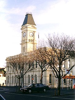
Oamaru is the largest town in North Otago, in the South Island of New Zealand, it is the main town in the Waitaki District. It is 80 kilometres (50 mi) south of Timaru and 120 kilometres (75 mi) north of Dunedin on the Pacific coast; State Highway 1 and the railway Main South Line connect it to both cities. With a population of 13,850, Oamaru is the 28th largest urban area in New Zealand, and the third largest in Otago behind Dunedin and Queenstown. The town is the seat of Waitaki District, which includes the surrounding towns of Kurow, Weston, Palmerston, and Hampden. which combined have a total population of 23,200.

Kurow Town in Canterbury, New Zealand

Kurow is a small town in the Waitaki District, New Zealand. It is located on the south bank of the Waitaki River, 60 kilometres (37 mi) northwest of Oamaru.

Waitaki District Territorial authority in New Zealand

Waitaki District is a territorial authority that is located in the Canterbury and Otago regions of the South Island of New Zealand. It straddles the traditional border between the two regions, the Waitaki River, and its seat is Oamaru.

Maniototo

The Maniototo Plain, usually simply known as The Maniototo, is an elevated inland region in Otago, New Zealand. The region roughly surrounds the upper reaches of the Taieri River and the Manuherikia River. It is bounded by the Kakanui Range to the north and the Rock and Pillar Range to the southeast. It has a harsh, dry climate, ranging from over 30 °C in mid-summer to -15 °C in mid-winter.

Hampden, New Zealand Town in Otago, New Zealand

Hampden, a small town in North Otago, New Zealand, lies close to the North Otago coast, 35 kilometres south of Oamaru and 80 kilometres north of the city of Dunedin, to both of which it is connected by State Highway 1.

Herbert, New Zealand Rural settlement in Otago, New Zealand

The small town of Herbert, formerly Otepopo, lies in North Otago, New Zealand, 91 kilometres (57 mi) north of Dunedin and 22 kilometres (14 mi) south-west of Oamaru. It lies on the edge of the Herbert Forest.

Kingston, New Zealand Rural settlement in Otago, New Zealand

Kingston is a small town at the southernmost end of Lake Wakatipu, just north of the border of Otago and Southland, in New Zealand's South Island. It is 47 kilometres south of Queenstown by a road, "The Devil's Staircase", which winds between the lake to the west and The Remarkables mountains to the east. It is 70 kilometres north of Lumsden, and close to the headwaters of the Mataura River.

Glenavy is a small town in the South Island of New Zealand. It is located at the southern extreme of the Canterbury region on the alluvial fan of the Waitaki River, three kilometres from the river's outflow into the Pacific Ocean.

Kakanui Place in Otago, New Zealand

The small town of Kakanui lies on the coast of Otago, in New Zealand, fourteen kilometres to the south of Oamaru. The Kakanui River and its estuary divide the township in two. The part of the settlement south of the river, also known as Kakanui South, formerly "Campbells Bay", was developed as a collection of cribs. A recent increase in the development of subdivisions has increased the density of dwellings within South Kakanui.

Omakau Rural settlement in Otago, New Zealand

Omakau is a settlement in Central Otago, New Zealand, located between Alexandra and Ranfurly on the northwest bank of the Manuherikia River. The smaller settlement of Ophir, New Zealand is located on the opposite bank, three kilometres to the southeast.

Ngapara is a locality in the north Otago region of New Zealand's South Island. It is located in a rural setting 25 km inland from Oamaru. The name of Ngapara is derived from the Māori word for the "tables" or plateaus of limestone in the area.

Pukeuri is a settlement to the north of Oamaru in the North Otago region of New Zealand's South Island. It is located near the coast in the Waitaki District that straddles the border of Otago and Canterbury.

Weston is a town situated 5 km (3.1 mi) inland from Oamaru, South Island, New Zealand. It is regarded as one of the more affluent towns of the Waitaki District and had a population of 1,050 in the 2018 census.

Broad Bay, New Zealand Settlement in New Zealand

The settlement of Broad Bay is located on the Otago Harbour coast of Otago Peninsula, in the South Island of New Zealand. It is administered as part of the city of Dunedin, and is technically a suburb of that city, though its isolation and semi-rural nature make it appear as a settlement in its own right.

Sawyers Bay Suburb of Dunedin in Dunedin City Council, New Zealand

Sawyers Bay is a suburb of the New Zealand city of Dunedin. It is located 1.5 kilometres (0.93 mi) to the southwest of Port Chalmers in a wide valley on the shore of Mussel Bay, 13 kilometres (8.1 mi) to the northeast of Dunedin city centre.

Heriot is a small settlement in West Otago, in the South Island of New Zealand. It is located 20 kilometres southwest of Raes Junction and 15 kilometres north of Tapanui.

Challis, New Zealand Suburb of Dunedin in Dunedin City Council, New Zealand

Challis is a settlement on the Otago Harbour coast of Otago Peninsula, within the city limits of the New Zealand city of Dunedin. Though officially regarded as a suburb, the isolated nature of Challis means that most locals regard it as a separate settlement within the city limits.

Stirling is a settlement in New Zealand. It is located in South Otago, approximately 5 km from Balclutha.

Taharua is a rural community in the Taupo District and Hawke's Bay Region of New Zealand's North Island, located around the Ōamaru and Taharua Rivers, which are tributaries of the Mohaka River.

Galloway, New Zealand Rural community in Otago, New Zealand

Galloway is a rural locality in the Central Otago District of Otago in New Zealand. It is about 6.5 km northeast of Alexandra, on the eastern bank of the Manuherikia River, opposite Springvale.

References

  1. 1 2 3 "ArcGIS Web Application". statsnz.maps.arcgis.com. Retrieved 2 December 2021.
  2. 1 2 3 "Statistical area 1 dataset for 2018 Census". Statistics New Zealand. March 2020. 7027679 (7027679). 2018 Census place summary: 7027679
  3. "The wreck of the TSS Maheno – an ANZAC story". University of Melbourne . Retrieved 19 February 2022.
  4. "Population estimate tables - NZ.Stat". Statistics New Zealand . Retrieved 22 October 2021.
  5. 1 2 "Statistical area 1 dataset for 2018 Census". Statistics New Zealand. March 2020. Maheno (343700). 2018 Census place summary: Maheno
  6. Education Counts: Maheno School
  7. "New Zealand Schools Directory". New Zealand Ministry of Education. Retrieved 22 December 2021.
  8. 1 2 3 4 "Opening of Maheno School". North Otago Times. 14 October 1875. p. 2. Retrieved 28 September 2009.
  9. "Maheno School". North Otago Times. 5 August 1875. p. 2. Retrieved 28 September 2009.
  10. Greenaway, Richard L. N. "Forrester, Thomas 1838 – 1907". Dictionary of New Zealand Biography. Ministry for Culture and Heritage. Retrieved 28 September 2009.
  11. Walton, Steven (18 February 2022). "The fascinating history of a WWI ship that has rested on a beach for 86 years". Stuff. Retrieved 25 February 2022.