
Geocaching is an outdoor recreational activity, in which participants use a Global Positioning System (GPS) receiver or mobile device and other navigational techniques to hide and seek containers, called "geocaches" or "caches", at specific locations marked by coordinates all over the world. A typical cache is a small waterproof container containing a logbook and sometimes a pen or pencil. The geocacher signs the log with their established code name and dates it, in order to prove that they found the cache. After signing the log, the cache must be placed back exactly where the person found it. Larger containers such as plastic storage containers or ammunition boxes can also contain items for trading, such as toys or trinkets, usually of more sentimental worth than financial. Geocaching shares many aspects with benchmarking, trigpointing, orienteering, treasure-hunting, letterboxing, waymarking and Munzee.

Ōmārama is a small town at the junction of State Highways 8 and 83, near the southern end of the Mackenzie Basin, in the South Island of New Zealand. Omarama is in the Waitaki District, in the southern Canterbury region. The Ahuriri River is a short distance to the north of the township. Ōmārama is 30 km southwest of Twizel, 40 km southeast of Lake Ōhau and 32 km northeast of the Lindis Pass.

Napier is a New Zealand city with a seaport, located in Hawke's Bay on the eastern coast of the North Island. The population of Napier is about 66,300 as of June 2020. About 18 kilometres (11 mi) south of Napier is the inland city of Hastings. These two neighbouring cities are often called "The Bay Cities" or "The Twin Cities" of New Zealand. The total population of the Napier-Hastings Urban Area is 132,560 people, which makes it the sixth-largest urban area in New Zealand, closely followed by Dunedin (106,200), and trailing Tauranga (151,300).

The Mackenzie Basin is an elliptical intermontane basin located in the Mackenzie and Waitaki Districts, near the centre of the South Island of New Zealand. It is the largest such basin in New Zealand. Historically famous mainly for sheep farming, the sparsely populated area is now also a popular tourism destination.

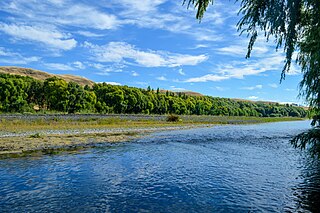
The Ahuriri River is a river in the Canterbury and Otago Regions of the South Island of New Zealand.

The Rangitīkei River is one of New Zealand's longest rivers, 253 kilometres (157 mi) long.

Lindis Pass is located in the South Island of New Zealand. A carpark at the top of the pass provides access to a viewpoint and two short trails to other viewing spots.

Lake Benmore is New Zealand's largest artificial lake. Located in the South Island of New Zealand and part of the Waitaki River, it was created in the 1960s by construction of Benmore Dam.

The former gold and coal mining town of St Bathans, formerly named Dunstan Creek, lies deep in the heart of the Maniototo in New Zealand's Otago region. The settlement was a centre of the Otago Gold Rush, but mining has since long ceased and it is now a tranquil holiday retreat. The preservation of many of its historic buildings makes it one of the region's more picturesque tourist venues. St Bathans is well known for its scenic man-made lake with beautiful looking clay cliffs that attract many tourists. It is currently a camping spot, and swimming is allowed in the lake.

Lake Ōhau is a lake in the Mackenzie Basin in the South Island of New Zealand. The Hopkins and Dobson rivers fed into the northern end of Lake Ōhau. These rivers have their headwaters in the Southern Alps / Kā Tiritiri o te Moana. The lake's outflow is the Ōhau River, which travels from the southeast corner of Lake Ōhau and feeds into the Waitaki River hydroelectric project. The Barrier range dominate the western side of Lake Ōhau, while the Ben Ohau range dominates the eastern side of Lake Ōhau. At the northern end of the lake, in between the Hopkins and Dobson rivers, lies the Naumann Range of mountains.

Napier Port is in Napier, New Zealand, on Hawke Bay. It is the North Island's second largest export port by tonnage, and is owned by Napier Port Holdings Limited.
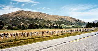
The Cardrona Bra Fence is a controversial tourist attraction in Central Otago, in New Zealand. At some point between 1998 and 1999, passers-by began to attach bras to a rural fence. The fence gradually became a well known site as the number of bras grew to hundreds. The fence is located on a public road reserve, adjacent to farm property in the Cardrona Valley area southwest of Wanaka, near to Cardrona.
The Tūtaekurī River flows through the Hawke's Bay Region of the eastern North Island of New Zealand. It flows east from the Kaweka Range, reaching the Pacific Ocean just to the south of Napier and Taradale, where the Ngaruroro and Clive Rivers join it. Starting roughly 50 kilometers north east of Taihape, the Tūtaekurī River flows for a distance of 99.9 kilometers.
Ahuriri is a suburb of the city of Napier, in the Hawke's Bay region of New Zealand's eastern North Island.

State Highway 83 (SH 83) is a South Island state highway in New Zealand running up the Waitaki Valley between the settlements of Pukeuri and Omarama. It forms part of the southernmost of the east-west roads crossing the South Island.

The Alps 2 Ocean Cycle Trail is a cycle trail funded as one of the projects of the New Zealand Cycle Trail. The trail extends more than 300 kilometres (190 mi) from Aoraki / Mount Cook to Oamaru on the Pacific Ocean. Suitable for all ages, the trail is an easy grade, and offers a mix of on and off-road trails.

Brachaspis robustus is a nationally endangered species of grasshopper endemic to the Mackenzie Basin of the South Island of New Zealand. The genus Brachaspis is endemic to the South Island of New Zealand. Although a grasshopper, it is a poor jumper, relying on camouflage to hide from predators. It is threatened by introduced mammals such as stoats, hedgehogs, and rats.
Ahuriri Harbour also known as Ahuriri Lagoon or locally just Ahuriri, was a former estuary and tidal lagoon located on the Eastern Coastline of New Zealand's North Island, just north of present-day Napier. It stretched several kilometers from north to south, and covered roughly 4000ha², or 40 km². Ahuriri was the final stop for the Tutaekuri and Waiohinganga Rivers, which made the lagoon and surrounding lands a sacred place to the native Māori. The European settlers also realised the importance of the area, particularly economic wise and Napier was soon settled.
Ahuriri Conservation Park is a protected area of 49,000 hectares including tussock grasslands, forest, and river habitat, located in Canterbury, South Island, New Zealand, and centred around the headwaters of the Ahuriri River.
