Kakanui

Last updated

Kakanui
Kakanui Presbyterian Church viewed from right.jpg
Kakanui Presbyterian Church
Kakanui
Coordinates: 45°11′S170°54′E / 45.183°S 170.900°E / -45.183; 170.900 Coordinates: 45°11′S170°54′E / 45.183°S 170.900°E / -45.183; 170.900
Country New Zealand
Region Otago
District Waitaki District
WardCorriedale Ward
Government
  Local authority Waitaki District Council
  Regional council Otago Regional Council
Area
[1]
  Total2.02 km2 (0.78 sq mi)
Population
 (2018 Census) [2]
  Total402
  Density200/km2 (520/sq mi)

The small town of Kakanui lies on the coast of Otago, in New Zealand, fourteen kilometres to the south of Oamaru. The Kakanui River and its estuary divide the township in two. The part of the settlement south of the river, also known as Kakanui South, formerly "Campbells Bay", was developed as a collection of cribs (holiday homes). A recent increase in the development of subdivisions has increased the density of dwellings within South Kakanui. [3] [4]

Contents

The Kakanui River reaches the sea near the town, and the low range known as the Kakanui Mountains stretches inland from south of Oamaru towards the Maniototo. Kai Tahu used to temporarily occupy Kakanui as they travelled north and south, as evidenced by the midden on the north side of the estuary.

The area around Kakanui has a reputation for its limestone formations, and produces many fossils. Quarrying formerly took place. The rich and fertile soil of the area around the river has physical properties which make it perfect for use in sports grounds, especially cricket pitches. Many of New Zealand's top cricket venues use Kakanui soil on their wicket blocks.

Beaches

Kakanui's main beach, south of the main headland, is known as Campbell's Bay. It provides the first surfable break and the first safe swimming beach (apart from Timaru's Caroline Bay) south of Banks Peninsula. The beach has a length of approximately two kilometres, and the southern end, known as All Day Bay, offers more shelter than the northern end, but with less surf. The sandy beach below the shingle spit north of the river mouth stretching toward Oamaru is safely swimmable. The beaches south of the main headland feature orange sand. The northern beach has white sand.

Horticulture

Kakanui's rich volcanic soil suits intensive horticulture. The township contains a number of glasshouses, primarily used for growing tomatoes, but also producing cucumbers and capsicums (bell peppers). Land surrounding the settlement (especially to the north towards the settlement of Totara) also features market gardens (often operated by Chinese New Zealanders) growing a wide range of vegetables. Kakanui has a particular reputation for its new-season potatoes, which sell throughout all New Zealand.

History

Kakanui (originally Kakaunui) was once a bustling port on the northern side of the river, with a hotel, blacksmith, meat works, and a post office. Kakanui's commerce declined after the construction of the railway inland[ when? ] (going through Maheno) and with the advent of the frozen-meat trade from 1882.

Demographics

Kakanui is described as a rural settlement by Statistics New Zealand, and covers 2.02 km2 (0.78 sq mi). [1] It is part of the larger Maheno statistical area. [5]

Historical population
YearPop.±% p.a.
2006375    
2013339−1.43%
2018402+3.47%
Source: [2]

Kakanui had a population of 402 at the 2018 New Zealand census, an increase of 63 people (18.6%) since the 2013 census, and an increase of 27 people (7.2%) since the 2006 census. There were 177 households. There were 198 males and 204 females, giving a sex ratio of 0.97 males per female, with 72 people (17.9%) aged under 15 years, 33 (8.2%) aged 15 to 29, 186 (46.3%) aged 30 to 64, and 102 (25.4%) aged 65 or older.

Ethnicities were 92.5% European/Pākehā, 9.0% Māori, 2.2% Pacific peoples, 1.5% Asian, and 3.0% other ethnicities (totals add to more than 100% since people could identify with multiple ethnicities).

Although some people objected to giving their religion, 59.0% had no religion, 29.9% were Christian, 0.7% were Buddhist and 3.0% had other religions.

Of those at least 15 years old, 72 (21.8%) people had a bachelor or higher degree, and 66 (20.0%) people had no formal qualifications. The employment status of those at least 15 was that 141 (42.7%) people were employed full-time, 54 (16.4%) were part-time, and 6 (1.8%) were unemployed. [2]

Naming error

Kakanui has been shown on LINZ maps as "Taranui" [6] since 1978. [7] [8] However, this name is not in use locally, nor is it evident on road signs. "Taranui" may be a naming error from early maps referring to a station farm of that name, located slightly inland from Kakanui.

View from Kakanui looking south over Campbell's Bay towards All Day Bay and Moeraki (the blueish-tinged headland in the extreme far distance) Kakanui.jpg
View from Kakanui looking south over Campbell's Bay towards All Day Bay and Moeraki (the blueish-tinged headland in the extreme far distance)

Related Research Articles

Oamaru Town in Otago, New Zealand

Oamaru is the largest town in North Otago, in the South Island of New Zealand, it is the main town in the Waitaki District. It is 80 kilometres (50 mi) south of Timaru and 120 kilometres (75 mi) north of Dunedin on the Pacific coast; State Highway 1 and the railway Main South Line connect it to both cities. With a population of 13,850, Oamaru is the 28th largest urban area in New Zealand, and the third largest in Otago behind Dunedin and Queenstown. The town is the seat of Waitaki District, which includes the surrounding towns of Kurow, Weston, Palmerston, and Hampden. which combined have a total population of 23,200.

Foxton, New Zealand Town in Manawatū-Whanganui, New Zealand

Foxton is a town in the Manawatū-Whanganui region of New Zealand - on the lower west coast of the North Island, in the Horowhenua district, 30 km (19 mi) southwest of Palmerston North and just north of Levin. The town is located close to the banks of the Manawatu River. It is situated on State Highway 1, roughly in the middle between Tongariro National Park and Wellington.

North Otago District in the New Zealand region Otago

North Otago in New Zealand covers the area of Otago between Shag Point and the Waitaki River, and extends inland to the west as far as the village of Omarama.

Waikanae Town in Wellington Region, New Zealand

Waikanae is a suburban town on the Kapiti Coast, 60 kilometres north of the Wellington CBD. The name is a Māori word meaning "waters" (wai) "of the grey mullet".

Waitaki District Territorial authority in New Zealand

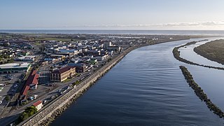
Waitaki District is a territorial authority that is located in the Canterbury and Otago regions of the South Island of New Zealand. It straddles the traditional border between the two regions, the Waitaki River, and its seat is Oamaru.

Hampden, New Zealand Town in Otago, New Zealand

Hampden, a small town in North Otago, New Zealand, lies close to the North Otago coast, 35 kilometres south of Oamaru and 80 kilometres north of the city of Dunedin, to both of which it is connected by State Highway 1.

Herbert, New Zealand Rural settlement in Otago, New Zealand

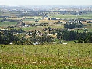
The small town of Herbert, formerly Otepopo, lies in North Otago, New Zealand, 91 kilometres (57 mi) north of Dunedin and 22 kilometres (14 mi) south-west of Oamaru. It lies on the edge of the Herbert Forest.
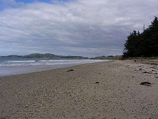
Papamoa Suburb of Tauranga in New Zealand

Papamoa or Papamoa Beach is a suburb of Tauranga, located about 11 kilometres from the city centre. It is the largest residential suburb in Tauranga. It is bordered to the west by Arataki and Mount Maunganui, the east by the Kaituna River and to the south by State Highway 2.

Maungaturoto Place in Northland Region, New Zealand

Maungaturoto is a small town in the Northland Region of New Zealand.

Foxton Beach Town in Manawatū-Whanganui region, New Zealand

Foxton Beach is a small settlement in the Horowhenua District of the Manawatū-Whanganui region of New Zealand's North Island. It is located on the South Taranaki Bight at the mouth of the Manawatu River, 35 kilometres southwest of Palmerston North, and six kilometres west of Foxton. Foxton Beach has a permanent population of around 2000 people. The town is a popular holiday destination due mainly to its beach and the bird sanctuary at the Manawatu Estuary. Most of Foxton Beach is made up of holiday homes.

Maketu Town in Bay of Plenty, New Zealand

Maketu is a small town on the Bay of Plenty Coast in New Zealand.

Coopers Beach Place in Northland Region, New Zealand

Coopers Beach is a settlement on the southern side of Doubtless Bay in Northland, New Zealand. State Highway 10 runs through it. It is one of the Taipa-Mangonui string of settlements, separated from Cable Bay on the west by Otanenui Stream and from Mangōnui on the east by Mill Bay Road.

Lyall Bay Suburb of Wellington City in New Zealand

Lyall Bay is a bay and a suburb on the south side of the Rongotai isthmus in Wellington, New Zealand.

Haumoana Place in Hawkes Bay, New Zealand

Haumoana is a coastal town just south of the Tukituki River outlet in Hawke Bay on the east coast of New Zealand's North Island. It is located 12 km south of Napier and ten kilometres east of Hastings. The village incorporates a school, a Presbyterian Church, a general store, a takeaway shop, a hall and a fire station. The village was developed as a holiday settlement with beaches, and the surrounding area has historically been used for sheep and cattle grazing and horticulture. However, lifestyle blocks and grape growing have become more prominent in recent times. Many inhabitants commute to the nearby cities to work. There are approximately 430 houses in Haumoana. The population at the 2013 census was 2256, an increase of 54 people since 2006.

Red Beach, New Zealand Suburb of Auckland in Auckland Council, New Zealand

Red Beach is a suburb surrounding the beach of the same name on the Hibiscus Coast, Auckland, New Zealand, at the base of the Whangaparaoa Peninsula. The suburb of Silverdale is to the south-west, and Orewa to the north. The beach is on the Hauraki Gulf and the suburb is bounded by two estuaries, that of the Weiti River to the south and the Orewa River to the north. The beach is named for the sand coloured by stamens from pōhutukawa trees.

Maheno, New Zealand Rural settlement in Otago, New Zealand

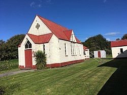
Maheno is a small North Otago township south of Oamaru in New Zealand. The area has 75 residents. A number of the town's streets are named after places in Tyne and Wear, England, such as Whickham, Felling, Heworth and Jarrow. One of two New Zealand's hospital ships in World War I, the SS Maheno, was named after this town.

Awatoto is a coastal suburb area located near Napier, Hawke's Bay, New Zealand.

Kawaha Point Suburb of Rotorua Lakes in New Zealand

Kawaha Point is a suburb of Rotorua in the Bay of Plenty Region of New Zealand's North Island.

Waiotahe Town in Bay of Plenty, New Zealand

Waiotahe is a beach, settlement and rural community in the Ōpōtiki District and Bay of Plenty Region of New Zealand's North Island, near the mouth and lowermost stretch of the Waiotahe River.

Longlands, New Zealand Rural community in Hawkes Bay Region, New Zealand

Longlands is a rural community in the Hastings District and Hawke's Bay Region of New Zealand's North Island. The area is on the southern and western outskirts of Hastings city.

References

  1. 1 2 "ArcGIS Web Application". statsnz.maps.arcgis.com. Retrieved 2 December 2021.
  2. 1 2 3 "Statistical area 1 dataset for 2018 Census". Statistics New Zealand. March 2020. 7027685, 7027686 and 7027687.
  3. http://www.waitaki.govt.nz/NR/rdonlyres/F44D4DBF8-738F-4CD7-A898-102CC642D020/35820/SubdivisionSummaryv8.pdf [ dead link ]
  4. "Archived copy" (PDF). Archived from the original (PDF) on 14 October 2008. Retrieved 30 June 2008.{{cite web}}: CS1 maint: archived copy as title (link)
  5. 2018 Census place summary: Maheno
  6. "Taranui". topomap.co.nz.
  7. "1:63360 map Sheet: S136 Oamaru". www.mapspast.org.nz. 1966. Retrieved 18 July 2022.
  8. "1:63360 map Sheet: S136 Oamaru". www.mapspast.org.nz. 1978. Retrieved 18 July 2022.