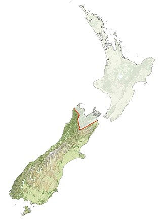
Ngāi Tahu, or Kāi Tahu, is the principal Māori iwi (tribe) of the South Island. Its takiwā is the largest in New Zealand, and extends from the White Bluffs / Te Parinui o Whiti, Mount Mahanga and Kahurangi Point in the north to Stewart Island / Rakiura in the south. The takiwā comprises 18 rūnanga corresponding to traditional settlements. According to the 2018 census an estimated 74,082 people affiliated with the Kāi Tahu iwi.

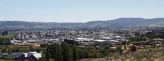
Mosgiel is an urban satellite of Dunedin in Otago, New Zealand, fifteen kilometres west of the city's centre. Since the re-organisation of New Zealand local government in 1989 it has been inside the Dunedin City Council area. Mosgiel has a population of approximately 14,800 as of June 2023. A nickname for Mosgiel is "The pearl of the plain". Its low-lying nature does pose problems, making it prone to flooding after heavy rains. Mosgiel takes its name from Mossgiel Farm, Ayrshire, the farm of the poet Robert Burns, the uncle of the co-founder in 1848 of the Otago settlement, the Reverend Thomas Burns.

Waitaki District is a territorial authority district that is located in the Canterbury and Otago regions of the South Island of New Zealand. It straddles the traditional border between the two regions, the Waitaki River, and its seat is Oamaru.

Palmerston is a town in the South Island of New Zealand. Located 50 kilometres to the north of the city of Dunedin, it is the largest town in the Waihemo Ward of the Waitaki District, with a population of 890 residents. Palmerston grew at a major road junction: State Highway 1 links Dunedin and Waikouaiti to the south with Oamaru and Christchurch to the north, while State Highway 85 heads inland to become the principal highway of the Maniototo. The Main South Line railway passes through the town and the Seasider tourist train travels from Dunedin to Palmerston and back once or twice a week. From 1880 until 1989, the town acted as the junction between the main line and a branch line that ran inland, the Dunback and Makareao Branches.

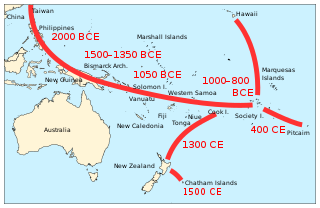
Kupe was a legendary Polynesian explorer who, according to Māori oral history, was the first person to discover New Zealand. It is likely that Kupe existed historically, but this is difficult to confirm. He is generally held to have been born to a father from Rarotonga and a mother from Raiatea, and probably spoke a Māori proto-language similar to Cook Islands Māori or Tahitian. His voyage to New Zealand ensured that the land was known to the Polynesians, and he would therefore be responsible for the genesis of the Māori people.

Sir John McKenzie was a New Zealand politician. He served as Minister of Lands and Agriculture in the Liberal Government of John Ballance.

Moeraki is a small fishing village on the east coast of the South Island of New Zealand. It was once the location of a whaling station. In the 1870s, local interests believed it could become the main port for the north Otago area and a railway line, the Moeraki Branch, was built to the settlement and opened in 1877. However, the port could not compete with Oamaru and the lack of traffic as well as stability problems caused by difficult terrain led to the closure of the railway in 1879 after only two years' operation.

Dunback, formerly Waihemo, is a small town in the Otago region of New Zealand. It is located between Palmerston and Ranfurly on Highway 85. It has a population of about 200 people. Most of these people live in the rural areas near the town.
Waitaha, an early Māori iwi, inhabited the South Island of New Zealand. They were largely absorbed via marriage and conquest – first by the Ngāti Māmoe and then by Ngāi Tahu – from the 16th century onward. Today those of Waitaha descent are represented by the Ngāi Tahu iwi. Like Ngāi Tahu today, Waitaha was itself a collection of various ancient iwi. Kāti Rākai was said to be one of Waitaha's hapū.
Tākitimu was a waka (canoe) with whakapapa throughout the Pacific particularly with Samoa, the Cook Islands, and New Zealand in ancient times. In several Māori traditions, the Tākitimu was one of the great Māori migration ships that brought Polynesian migrants to New Zealand from Hawaiki. The canoe was said to have been captained by Tamatea.

Āraiteuru was a canoe of some of Ngāi Tahu's ancestors in Māori tradition.

Māori mythology and Māori traditions are two major categories into which the remote oral history of New Zealand's Māori may be divided. Māori myths concern tales of supernatural events relating to the origins of what was the observable world for the pre-European Māori, often involving gods and demigods. Māori tradition concerns more folkloric legends often involving historical or semi-historical forebears. Both categories merge in whakapapa to explain the overall origin of the Māori and their connections to the world which they lived in.
The Otago region of New Zealand is one of the more isolated places of the inhabited earth. Its high latitude, elevation and distance from larger foreign and domestic population centres have defined Otago at each stage of its history.

The Kātiki Point Lighthouse, also known as Moeraki Lighthouse, shone for the first time in 1878, following several accidents on the dangerous reefs around the area, to make the area safer for ships that sailed past on their way to Port Chalmers, Dunedin. The lighthouse was built between the settlements of Moeraki and Kātiki, on the tip of the Moeraki Peninsula, which is known as Kātiki Point or Moeraki Point.
In Māori tradition, Mānuka was one of the great ocean-going, voyaging canoes that was used in the migrations that settled the South Island of Aotearoa. The canoe is said to have travelled to the Polynesian homeland of Hawaiki to procure kūmara, a type of sweet potato. Although the Mānuka returned with kūmara, most accounts state that efforts to germinate and grow the tubers it brought back ended in failure.
Uruaokapuarangi was one of the great ocean-going, voyaging canoes that was used in the migrations that settled the South Island according to Māori tradition.
Wakari is a residential suburb of the New Zealand city of Dunedin. It is located 2.5 kilometres (1.6 mi) to the northwest of the city centre, immediately to the west of the ridge which runs to the west of the city's centre. Wakari lies to the north of the upper reaches of the Kaikorai Valley, and is also north of the suburb of Kaikorai. The suburbs of Roslyn and Maori Hill are situated on the ridge immediately to the southeast and east of Wakari. The suburb of Halfway Bush lies to the northwest, and the smaller suburb of Helensburgh lies to the north.

Since the early 1900s the fact that Polynesians were the first ethnic group to settle in New Zealand has been accepted by archaeologists and anthropologists. Before that time and until the 1920s, however, a small group of prominent anthropologists proposed that the Moriori people of the Chatham Islands represented a pre-Māori group of people from Melanesia, who once lived across all of New Zealand and were replaced by the Māori. While this claim was soon disproven by academics, it was widely and controversially incorporated into school textbooks during the 20th century, most notably in the School Journal. This theory subsequently spawned modern claims of a pre-Māori settlement of New Zealand by various ethnic groups, many conspiratorial in nature. Today, such theories are considered to be pseudohistorical and negationist by scholars and historians.
Rākaihautū was the captain of the Uruaokapuarangi canoe and a Polynesian ancestor of various iwi, most famously of Waitaha and other southern groups, though he is also known in the traditions of Taitokerau and in those of Rarotonga.


