
Omarama is a small town at the junction of State Highways 8 and 83, near the southern end of the Mackenzie Basin, in the South Island of New Zealand. Omarama is in the Waitaki District, in the southern Canterbury region. The Ahuriri River is a short distance to the north of the township. Omarama is 30 km southwest of Twizel, 40 km southeast of Lake Ōhau and 32 km northeast of the Lindis Pass.
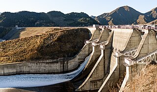
Benmore Dam is the largest dam within the Waitaki power scheme, located in the Canterbury Region of New Zealand's South Island. There are eight other power stations in the Waitaki Power Scheme.

The Mackenzie Basin, popularly and traditionally known as the Mackenzie Country, is an elliptical intermontane basin located in the Mackenzie and Waitaki Districts, near the centre of the South Island of New Zealand. It is the largest such basin in New Zealand. Historically famous mainly for sheep farming, the sparsely populated area is now also a popular tourism destination.

The Ahuriri River is a river in the Canterbury and Otago Regions of the South Island of New Zealand.

The Waitaki River is a large braided river in the South Island of New Zealand. It drains the Mackenzie Basin and runs 209 kilometres (130 mi) south-east to enter the Pacific Ocean between Timaru and Oamaru on the east coast. It starts at the confluence of the Ōhau and Tekapo rivers, now at the head of the artificial Lake Benmore, these rivers being fed by three large glacial lakes, Pukaki, Tekapo, and Ōhau at the base of the Southern Alps. The Waitaki flows through Lake Benmore, Lake Aviemore and Lake Waitaki, these lakes being contained by hydroelectric dams, Benmore Dam, Aviemore Dam and Waitaki Dam. The Waitaki has several tributaries, notably the Ahuriri River and the Hakataramea River. It passes Kurow and Glenavy before entering the Pacific Ocean. The River lends its name the Waitaki District on the south side of the river bank.

Twizel is the largest town in the Mackenzie District, in the Canterbury Region of the South Island of New Zealand. The town was founded in 1968 to house construction workers on the Upper Waitaki Hydroelectric Scheme. Today, Twizel is a service and tourist town for visitors to the area. It has a resident population of 1,850 ; during the summer, holidaymakers nearly triple the town's population.

Waitaki District is a territorial authority district that is located in the Canterbury and Otago regions of the South Island of New Zealand. It straddles the traditional border between the two regions, the Waitaki River, and its seat is Oamaru.
Lake Ruataniwha is an artificial lake in the Mackenzie Basin in the South Island of New Zealand. It was formed in 1977–1981 as part of the Waitaki hydroelectric project. It lies on the traditional boundary of the Canterbury and Otago provinces, with the town of Twizel two kilometres to the north.

Lake Ōhau is a lake in the Mackenzie Basin in the South Island of New Zealand. The Hopkins and Dobson rivers fed into the northern end of Lake Ōhau. These rivers have their headwaters in the Southern Alps. The lake's outflow is the Ōhau River, which travels from the southeast corner of Lake Ōhau and feeds into the Waitaki River hydroelectric project. The Barrier range dominate the western side of Lake Ōhau, while the Ben Ohau range dominates the eastern side of Lake Ōhau. At the northern end of the lake, in between the Hopkins and Dobson rivers, lies the Naumann Range of mountains.
Lake Waitaki is the smallest, oldest and most downstream of the three man-made lakes on the Waitaki River, and forms part of the Waitaki hydroelectric scheme in New Zealand's South Island. It lies downstream of lakes Aviemore and Benmore on the Waitaki River, close to the town of Kurow. It is part of the traditional boundary of the Canterbury and Otago regions (although the official border has been moved southward to include the entire lake, as well as the entire northwest portion of Waitaki District within the Canterbury Region.

Lake Aviemore or Mahi Tikumu is a man-made lake in New Zealand's South Island, part of the Waitaki hydroelectric scheme. Immediately upstream is Lake Benmore and downstream Lake Waitaki. Aviemore lies on both sides of the border between the Waimate and Waitaki districts.
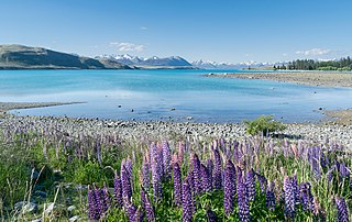
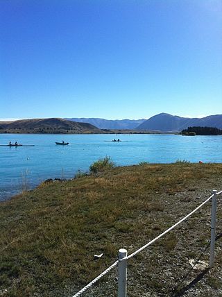
Lake Tekapo is the second-largest of three roughly parallel lakes running north–south along the northern edge of the Mackenzie Basin in the South Island of New Zealand. It covers an area of 83 km2 (32 sq mi) and is at an altitude of 710 m (2,330 ft) above sea level.

The Tekapo River flows occasionally through the Mackenzie Basin, Canterbury, in New Zealand's South Island, although the riverbed is now often dry in the upper reaches. It maintains a constant flow below the confluence of several tributaries, notably the Maryburn, Forks, and Grays rivers.

The Pukaki River flows through the Mackenzie Basin, Canterbury, in New Zealand's South Island.

Hydroelectric power in New Zealand has been a part of the country's energy system for over 100 years and continues to provide more than half of the country's electricity needs. Hydroelectricity is the primary source of renewable energy in New Zealand. Power is generated the most in the South Island and is used most in the North Island.

Cougar Dam is a 519-foot (158 m) tall rockfill hydroelectric dam in the U.S. state of Oregon. It has a gated concrete spillway and a powerhouse with two turbines totaling 25 megawatts of electric power.

The Alps 2 Ocean Cycle Trail is a cycle trail in New Zealand. This trail is one of the projects of the New Zealand Cycle Trail project. The trail extends more than 300 kilometres (190 mi) from Aoraki / Mount Cook to Oamaru on the Pacific Ocean. From west to east, it descends from an altitude of 780 metres (2,560 ft) down to sea level. The trail has both on and off-road sections.

The Ōhau River is a river in the Mackenzie Basin of New Zealand's South Island. It is the primary outflow of Lake Ōhau, from which it flows in a roughly eastward direction until reaching the artificial Lake Benmore after a distance of roughly 27 kilometres (17 mi). In 1981, the artificial Lake Ruataniwha was created along the river's length to power a small hydroelectric power station as part of the Waitaki hydro scheme. Prior to the creation of the Waitaki hydro scheme, the river flowed directly into the Waitaki River rather than through a series of lakes. The river forms part of the traditional boundary between Otago and Canterbury regions.

The Waitaki Dam is one of eight hydroelectric power stations which form the Waitaki hydroelectric scheme on the Waitaki River in the Canterbury Region of New Zealand. The dam was the first of three to be built on the Waitaki River and was constructed without earthmoving machinery; over half a million cubic metres of material was excavated, almost entirely by pick-and-shovel. The Waitaki Dam's construction was followed by the development of Aviemore Dam and Benmore Dam, and importantly, every dam built in New Zealand since the Waitaki has benefited from lessons learned during its construction.


