
Godley is a city in northwestern Johnson County, Texas, United States, in the Dallas–Fort Worth metroplex. It is on Texas State Highway 171, Farm Roads 2331 and 917, and the tracks of the Atchison, Topeka and Santa Fe Railway northwest of Cleburne. The population was 1,450 in 2020, up from 1,009 in 2010.

Lake Itasca is a small glacial lake, approximately 1.8 square miles in area. It is located in Itasca State Park, in south-eastern Clearwater County, in the Headwaters area of north-central Minnesota, and is notable for being the headwater of the Mississippi River. It has an average depth of 20 to 35 feet and is 1,475 feet (450 m) above sea level.

The headwater of a river or stream is the farthest point on each of its tributaries upstream from its mouth/estuary into a lake/sea or its confluence with another river. Each headwater is considered one of the river's sources, as it is the place where surface runoffs from rainwater, meltwater and/or spring water begin accumulating into a more substantial and consistent flow that becomes a first-order tributary of that river. The tributary with the longest course downstream of the headwaters is regarded as the main stem.

The Sawatch Range or Saguache Range is a high and extensive mountain range in central Colorado which includes eight of the twenty highest peaks in the Rocky Mountains, including Mount Elbert, at 14,440 feet (4,401 m) elevation, the highest peak in the Rockies.

Godley was a hundred in what is now Surrey, England. Egham, Thorpe, Chertsey and Chobham are all mentioned in the Chertsey Abbey charter of 673 AD due to a donation by Frithuwold. Chobham manor needed to be large to have a reasonable economic importance as it covered very poor quality heathland. Most of the population of the hundred would have settled on the more fertile alluvial soil bordering the River Thames.

The Mosquito Range is a high mountain range in the Rocky Mountains of central Colorado in the United States. The peaks of the range form a ridge running north–south for roughly 40 mi (64 km) from southern Summit County on the north end, then along the boundary between Lake and Park Counties. The ranges forms a high barrier separating the headwaters of the Arkansas River near Leadville from South Park and the headwaters of the South Platte River near Fairplay. The highest peak in the range is Mount Lincoln at an elevation of 14,286 ft. Other fourteeners in the range are Quandary Peak (14,272 ft), Mount Bross (14,172 ft), Mount Democrat (14,148 ft), and Mount Sherman (14,036 ft).

Janey Godley is a Scottish stand-up comedian, actress and writer from Glasgow.

Arcadia is a region in the central Peloponnese. It takes its name from the mythological character Arcas, and in Greek mythology it was the home of the gods Hermes and Pan. In European Renaissance arts, Arcadia was celebrated as an unspoiled, harmonious wilderness; as such, it was referenced in popular culture.
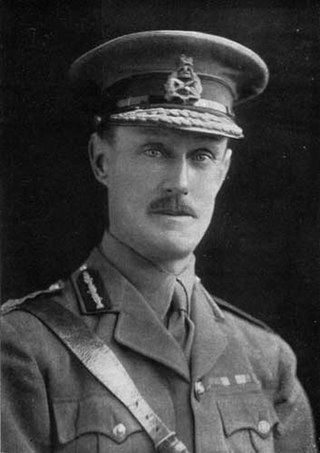
General Sir Alexander John Godley, was a senior British Army officer. He is best known for his role as commander of the New Zealand Expeditionary Force and II Anzac Corps during the First World War.
Spatsizi Headwaters Provincial Park is a provincial park in the Stikine Region of British Columbia, Canada. It was established on January 25, 2001 to protect the headwaters of the Spatsizi River while providing recreational facilities for visitors.
Pleasant River is a 4.7-mile-long (7.6 km) river in Oxford County, Maine in the United States. It is a tributary of the Androscoggin River, which flows east and south to join the Kennebec River in Merrymeeting Bay near the Atlantic Ocean.
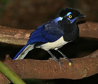
The plush-crested jay is a jay of the family Corvidae. It is found in central-southern South America: in southwestern Brazil, Bolivia, Paraguay, Uruguay, and northeastern Argentina, including southern regions of the Amazon Basin river systems bordering the Pantanal.

Missouri Headwaters State Park is a public recreation area occupying 535 acres (217 ha) at the site of the official start of the Missouri River. The park offers camping, hiking trails, hunting, and water-related activities. It is located on Trident Road northeast of Three Forks, Montana at an elevation of 4,045 feet (1,233 m). The park includes the Three Forks of the Missouri National Historic Landmark, designated in 1960 because the site is one where the Lewis and Clark Expedition camped in 1805.
Doubletop Mountain is a mountain located in Ulster County, New York. The mountain is part of the Catskill Mountains. Doubletop Mountain is flanked to the northwest by Graham Mountain, to the east by Big Indian Mountain, and to the southwest by the Beaver Kill Range.

The Sacred Headwaters is a large subalpine drainage basin centred around Klappan Mountain of the Klappan Range in northern British Columbia. It is the source of three wild salmon rivers: the Skeena River, Nass River, and Stikine River. It is also referred to as the Klappan Valley, although the Klappan—a tributary of the Stikine River—is only one of the area's watersheds. Local Tahltan people call the area Klabona, which is loosely translated as "headwaters".

Bell Creek is a 10-mile-long (16 km) tributary of the Los Angeles River, in the Simi Hills of Ventura County and the San Fernando Valley of Los Angeles County and City, in Southern California.
Efrenk River is a short river in Mersin Province, Turkey. It was originally called Efrenk River. After a mosque named Müftü Mosque was built by the river in Mersin, it was popularly renamed Müftü River.
Moyer Creek starts at Wheelock Pond near Jerusalem Hill, New York. Past Gulph, New York Moyer Creek follows a deep ravine, the Frankfort Gorge, south towards Frankfort, New York before converging with the Mohawk River in Frankfort, New York. The headwaters of Moyer Creek rise within a half mile of the source of the Unadilla River which is the most northerly headwater source of the Susquehanna and the closest to the Mohawk River.
Headwaters State Forest is a 6,730-acre (27.2 km2) state forest, located in Transylvania County, North Carolina, along the South Carolina state line and is part of a larger 100,000+ acre conservation corridor that stretches some 80 miles along the state line. The name originates from the fact that the forest contains the headwaters of East Fork of the French Broad River. The North Carolina Forest Service primarily manages the forest for water and soil quality, as well as protecting rare species; however, primitive recreational uses are permitted.


