Mount Cook Village

Last updated • 5 min readFrom Wikipedia, The Free Encyclopedia

Mount Cook Village
Town
Aoraki / Mount Cook
View over Mount Cook Village to The Footstool and Mount Cook.jpg
Mount Cook Village down below in Hooker Valley, The Hermitage on the left, lodge and motel complex on the bottom right
Mount Cook Village
Coordinates: 43°44′0″S170°5′44″E / 43.73333°S 170.09556°E / -43.73333; 170.09556
CountryNew Zealand
Island South Island
Region Canterbury
Territorial Authority Mackenzie District
WardPukaki Ward
CommunityTwizel Community
Electorates
Government
  Territorial authority Mackenzie District Council
  Regional council Environment Canterbury
   Mayor of Mackenzie Anne Munro
   Waitaki MP Miles Anderson
   Te Tai Tonga MP Tākuta Ferris
Area
[1]
  Total
4.26 km2 (1.64 sq mi)
Elevation
750 m (2,460 ft)
Population
 (June 2024) [2]
  Total
200
  Density47/km2 (120/sq mi)

Mount Cook Village, officially Aoraki / Mount Cook, [a] is located within New Zealand's Aoraki / Mount Cook National Park at the end of State Highway 80, only 15 kilometres (9.3 mi) [3] south of the summit of the country's highest mountain, also called Aoraki / Mount Cook, in the Southern Alps.

Contents

Being situated inside a national park, it is not possible to own property in Mount Cook Village; however, because of the year-round operation of the hotel and motels, the village has a small permanent population of around 250. [4]

All buildings and facilities operate on concessions and leases from the government. The village has no grocery stores apart from a small in-hotel convenience store. The nearest supermarket is 65 kilometres (40 mi) away in Twizel, the closest town. There is a self-service petrol pump behind the hotel complex; however, the fuel price reflects the remote location.[ citation needed ]

Mount Cook Village operates a small school with a roll as low as a dozen children, the only school in New Zealand inside a national park. [5]

History

The first building at the location of Mount Cook Village was the second Hermitage hotel, built in 1913 and opened in 1914; however, that building burned to the ground in 1957 and was replaced in 1958 by what later became the current hotel.

The 1960s and 1970s saw significant extensions to the hotel and Mount Cook Village, including water mains, sewerage treatment, local streets, and the sealing of State Highway 80, which greatly improved access. A local fire brigade was established in 1976. [4]

The official name of the settlement was amended to a dual name, Aoraki / Mount Cook, [a] by the Ngāi Tahu Claims Settlement Act 1998. [6]

Demographics

Mount Cook Village is described by Statistics New Zealand as a rural settlement, and covers 4.26 km2 (1.64 sq mi). [1] It had an estimated population of 200 as of June 2024, [2] with a population density of 47 people per km2. It is part of the Mackenzie Lakes statistical area. [7]

Historical population
YearPop.±% p.a.
2006210    
2013201−0.62%
2018213+1.17%
Source: [8]

Before the 2023 census, Mount Cook Village had a larger boundary, covering 9.68 km2 (3.74 sq mi). [1] Using that boundary, Mount Cook Village had a population of 213 at the 2018 New Zealand census, an increase of 12 people (6.0%) since the 2013 census, and an increase of 3 people (1.4%) since the 2006 census. There were 27 households, comprising 99 males and 114 females, giving a sex ratio of 0.87 males per female. The median age was 29.5 years (compared with 37.4 years nationally), with 24 people (11.3%) aged under 15 years, 87 (40.8%) aged 15 to 29, 93 (43.7%) aged 30 to 64, and 6 (2.8%) aged 65 or older.

Ethnicities were 53.5% European/Pākehā, 2.8% Māori, 8.5% Pasifika, 25.4% Asian, and 14.1% other ethnicities. People may identify with more than one ethnicity.

Although some people chose not to answer the census's question about religious affiliation, 52.1% had no religion, 28.2% were Christian, 1.4% were Hindu, 1.4% were Muslim, 9.9% were Buddhist and 1.4% had other religions.

Of those at least 15 years old, 45 (23.8%) people had a bachelor's or higher degree, and 12 (6.3%) people had no formal qualifications. The median income was $35,200, compared with $31,800 nationally. 12 people (6.3%) earned over $70,000 compared to 17.2% nationally. The employment status of those at least 15 was that 177 (93.7%) people were employed full-time, and 9 (4.8%) were part-time. [8]

Mount Sefton LC0291.jpg
Panorama of Hooker valley with Mount Cook Village on left in front of the Sealy Range, and Mount Sefton and The Footstool in the center of the frame

Tourism

Mount Cook Village caters to a steady flow of around 250,000 visitors per year [4] with a wide range of facilities and accommodation.

An international style hotel, The Hermitage , [9] the name of which dates back to the original hotel built in 1884, is the only prominent larger building in the village and a popular location, especially for international tourists. The Hermitage is sometimes used as an alternative name for the settlement. The hotel also owns and operates chalets and a lodge and motel with options ranging from backpacker accommodation through to family units.

There are two more motels in the village, and a total of four restaurants or pubs, two of which are inside the main hotel complex. The buildings and motel units are connected via paved footpaths. The small White Horse Hill camping ground is located about 2 kilometres (1.2 mi) outside the village, connected via a walking track.

Commercial operations run guided walks, 4WD safaris, boating on the Tasman glacier lake, horse treks, fishing, and scenic flights including landing on the glaciers. These are based at the hotel, departing and returning to the hotel's main entrance.

A number of nearby walks and climbs ranging from 10 minute bush walks to multi-day tramping tracks and routes can be explored from Mount Cook Village.

There are three short walking tracks through forest areas within the village and on its outskirts, as well as the starting points of longer walking tracks ranging from the popular and easy Hooker Valley Track to more strenuous walks such as the steep track to Sealy Tarns. [10]

The village is home to the park's visitor centre, [11] and the starting point for climbers, hunters [12] and trampers visiting the many huts. [13]

The YHA backpacker hostel is due to close permanently in December 2021 due to the ongoing Covid-19 pandemic. [14]

Climate

Mount Cook Village has an oceanic climate (Cfb). Summers are mild with cool nights while winters are chilly with nightly lows below freezing. Precipitation is extremely heavy year round.

Climate data for Mount Cook Village, elevation 730 m (2,400 ft), (1991–2020 normals, extremes 1929-present)
MonthJanFebMarAprMayJunJulAugSepOctNovDecYear
Record high °C (°F)32.8
(91.0)
32.4
(90.3)
29.9
(85.8)
24.4
(75.9)
23.2
(73.8)
19.0
(66.2)
18.3
(64.9)
22.1
(71.8)
25.0
(77.0)
25.7
(78.3)
28.6
(83.5)
30.1
(86.2)
32.8
(91.0)
Mean maximum °C (°F)28
(82)
27.6
(81.7)
25.5
(77.9)
21.9
(71.4)
18.1
(64.6)
14.8
(58.6)
14.0
(57.2)
15.6
(60.1)
19.0
(66.2)
21.9
(71.4)
24.4
(75.9)
26
(79)
29.7
(85.5)
Mean daily maximum °C (°F)20.4
(68.7)
20.8
(69.4)
18.4
(65.1)
14.9
(58.8)
11.0
(51.8)
7.9
(46.2)
7.2
(45.0)
9.1
(48.4)
11.8
(53.2)
14.0
(57.2)
16.3
(61.3)
18.5
(65.3)
14.2
(57.6)
Daily mean °C (°F)14.6
(58.3)
14.7
(58.5)
12.4
(54.3)
9.4
(48.9)
6.2
(43.2)
3.2
(37.8)
2.5
(36.5)
4.1
(39.4)
6.6
(43.9)
8.6
(47.5)
10.6
(51.1)
12.8
(55.0)
8.8
(47.8)
Mean daily minimum °C (°F)8.7
(47.7)
8.5
(47.3)
6.5
(43.7)
4.0
(39.2)
1.3
(34.3)
−1.4
(29.5)
−2.2
(28.0)
−0.8
(30.6)
1.5
(34.7)
3.1
(37.6)
5.0
(41.0)
7.0
(44.6)
3.4
(38.1)
Mean minimum °C (°F)2
(36)
2.1
(35.8)
0.4
(32.7)
−1.5
(29.3)
−3.7
(25.3)
−6.8
(19.8)
−7.2
(19.0)
−5.8
(21.6)
−4.0
(24.8)
−2.7
(27.1)
−1.1
(30.0)
1.2
(34.2)
−8.3
(17.1)
Record low °C (°F)−8.3
(17.1)
−4.4
(24.1)
−7.2
(19.0)
−7.8
(18.0)
−13.3
(8.1)
−13.9
(7.0)
−16.9
(1.6)
−12.8
(9.0)
−15.0
(5.0)
−10.0
(14.0)
−12.2
(10.0)
−10.6
(12.9)
−16.9
(1.6)
Average rainfall mm (inches)418.7
(16.48)
272.0
(10.71)
315.0
(12.40)
336.5
(13.25)
377.8
(14.87)
291.0
(11.46)
288.6
(11.36)
283.8
(11.17)
361.0
(14.21)
394.4
(15.53)
367.6
(14.47)
425.9
(16.77)
4,132.3
(162.68)
Average rainy days (≥ 1.0 mm)11.39.010.011.515.214.213.213.615.015.813.513.8156.1
Average relative humidity (%)64.769.873.776.181.482.079.079.467.566.364.166.772.6
Mean monthly sunshine hours 183.5172.3157.5123.886.073.480.0112.8121.1152.1165.8178.91,607.2
Source: NIWA Climate Data [15] [16]
Climate data for Mt Cook Airport, elevation 656 m (2,152 ft), (2012-2024 normals, extremes 2012-present)
MonthJanFebMarAprMayJunJulAugSepOctNovDecYear
Record high °C (°F)33.5
(92.3)
30.5
(86.9)
27.2
(81.0)
23.7
(74.7)
20.3
(68.5)
17.9
(64.2)
16.0
(60.8)
17.7
(63.9)
22.3
(72.1)
26.1
(79.0)
28.5
(83.3)
29.3
(84.7)
33.5
(92.3)
Mean maximum °C (°F)29.2
(84.6)
28.0
(82.4)
25.6
(78.1)
22.2
(72.0)
18.9
(66.0)
14.9
(58.8)
14.3
(57.7)
15.3
(59.5)
18.9
(66.0)
22.7
(72.9)
24.8
(76.6)
27.0
(80.6)
30.2
(86.4)
Mean daily maximum °C (°F)22.0
(71.6)
21.7
(71.1)
19.3
(66.7)
15.1
(59.2)
11.9
(53.4)
8.3
(46.9)
7.9
(46.2)
9.6
(49.3)
12.2
(54.0)
14.9
(58.8)
17.1
(62.8)
19.8
(67.6)
15.0
(59.0)
Daily mean °C (°F)15.5
(59.9)
15.2
(59.4)
12.9
(55.2)
9.5
(49.1)
6.5
(43.7)
3.2
(37.8)
2.8
(37.0)
4.3
(39.7)
6.6
(43.9)
9.2
(48.6)
11.3
(52.3)
13.9
(57.0)
9.2
(48.6)
Mean daily minimum °C (°F)9.1
(48.4)
8.7
(47.7)
6.6
(43.9)
3.9
(39.0)
1.2
(34.2)
−1.8
(28.8)
−2.4
(27.7)
−0.9
(30.4)
1.0
(33.8)
3.5
(38.3)
5.6
(42.1)
8.1
(46.6)
3.6
(38.4)
Mean minimum °C (°F)1.2
(34.2)
1.8
(35.2)
0.0
(32.0)
−2.6
(27.3)
−6.0
(21.2)
−8.7
(16.3)
−9.8
(14.4)
−8.6
(16.5)
−6.9
(19.6)
−4.4
(24.1)
−1.5
(29.3)
0.8
(33.4)
−11.6
(11.1)
Record low °C (°F)−1.9
(28.6)
−0.2
(31.6)
−2.0
(28.4)
−4.5
(23.9)
−8.8
(16.2)
−15.0
(5.0)
−13.7
(7.3)
−14.1
(6.6)
−9.6
(14.7)
−7.5
(18.5)
−3.7
(25.3)
−1.7
(28.9)
−15.0
(5.0)
Average rainfall mm (inches)235.7
(9.28)
136.8
(5.39)
152.6
(6.01)
191.8
(7.55)
233.7
(9.20)
227.5
(8.96)
235.0
(9.25)
191.1
(7.52)
224.7
(8.85)
223.8
(8.81)
190.3
(7.49)
197.1
(7.76)
2,440.1
(96.07)
Source: NIWA [17]
Climate data for Mueller Hut, elevation 1,818 m (5,965 ft), (1991–2020)
MonthJanFebMarAprMayJunJulAugSepOctNovDecYear
Mean daily maximum °C (°F)10.9
(51.6)
11.8
(53.2)
10.3
(50.5)
7.3
(45.1)
4.9
(40.8)
3.7
(38.7)
2.0
(35.6)
2.8
(37.0)
3.8
(38.8)
4.7
(40.5)
7.2
(45.0)
9.3
(48.7)
6.6
(43.8)
Daily mean °C (°F)7.4
(45.3)
8.3
(46.9)
6.9
(44.4)
3.9
(39.0)
1.9
(35.4)
0.2
(32.4)
−1.2
(29.8)
−0.8
(30.6)
0.1
(32.2)
1.3
(34.3)
3.5
(38.3)
5.6
(42.1)
3.1
(37.6)
Mean daily minimum °C (°F)3.8
(38.8)
4.9
(40.8)
3.5
(38.3)
0.6
(33.1)
−1.1
(30.0)
−3.2
(26.2)
−4.4
(24.1)
−4.3
(24.3)
−3.5
(25.7)
−2.0
(28.4)
−0.3
(31.5)
2.0
(35.6)
−0.3
(31.4)
Source: NIWA [18]

Education

Aoraki Mount Cook School is a full primary school serving years 1 to 8, [19] with a roll of 5 students as of November 2024. [20] The school opened in 1960. [21]

Notes

  1. 1 2 The town’s official name, as it was changed in 1998, is 'Aoraki/Mount Cook', without spaces between names. It is expected that the New Zealand Geographic Board will change the name to include spaces around the slash in future.

Related Research Articles

<span class="mw-page-title-main">Aoraki / Mount Cook</span> Highest mountain in New Zealand

Aoraki / Mount Cook is the highest mountain in New Zealand. Its height, as of 2014, is listed as 3,724 metres. It is situated in the Southern Alps, the mountain range that runs the length of the South Island. A popular tourist destination, it is also a favourite challenge for mountain climbers. Aoraki / Mount Cook consists of three summits: from south to north, the Low Peak, the Middle Peak and the High Peak. The summits lie slightly south and east of the main divide of the Southern Alps, with the Tasman Glacier to the east and the Hooker Glacier to the southwest. Mount Cook is ranked 10th in the world by topographic isolation.

<span class="mw-page-title-main">Aoraki / Mount Cook National Park</span> National park in New Zealand

Aoraki / Mount Cook National Park is a national park located in the Canterbury Region in the central-west of the South Island of New Zealand. It was established in October 1953 and takes its name from the highest mountain in New Zealand, Aoraki / Mount Cook. The area of the park is 707 km2 (273 sq mi), and it shares a border with Westland Tai Poutini National Park along the Main Divide of the Southern Alps. The national park consists of reserves that were established as early as 1885 to protect the area's significant landscape and vegetation. Glaciers cover 40% of the park, including the county's largest glacier, Haupapa / Tasman Glacier. In 1990, the park was included in the area designated as the Te Wāhipounamu World Heritage Site. The park is managed by the Department of Conservation (DOC) alongside Ngāi Tahu, the iwi who are mana whenua in the region.

<span class="mw-page-title-main">Mount John University Observatory</span> Astronomical research observatory in New Zealand

University of Canterbury Mount John Observatory (UCMJO), previously known as Mt John University Observatory (MJUO), is New Zealand's premier astronomical research observatory. It is situated at 1,029 metres (3,376 ft) ASL atop Mount John at the northern end of the Mackenzie Basin in the South Island, and was established in 1965. There are many telescopes on site including: one 0.4 metre, two 0.6 metre, one 1.0 metre, and a 1.8 metre MOA telescope. The nearest population centre is the resort town of Lake Tekapo (pop. >500). Approximately 20% of nights at UCMJO are photometric, with a larger number available for spectroscopic work and direct imaging photometry.

<span class="mw-page-title-main">Mackenzie Basin</span> Area of land in the South Island of New Zealand

The Mackenzie Basin, popularly and traditionally known as the Mackenzie Country, is an elliptical intermontane basin located in the Mackenzie and Waitaki Districts, near the centre of the South Island of New Zealand. It is the largest such basin in New Zealand. Historically famous mainly for sheep farming, the sparsely populated area is now also a popular tourism destination.

<span class="mw-page-title-main">Hanmer Springs</span> Town in the South Island of New Zealand

Hanmer Springs is a small town in the Canterbury region of the South Island of New Zealand. The Māori name for Hanmer Springs is Te Whakatakanga o te Ngārahu o te ahi a Tamatea, which means "where the ashes of Tamatea's fire lay", referring to Tamatea, the captain of the canoe Tākitimu.

<span class="mw-page-title-main">Fairlie, New Zealand</span> Town in the South Island of New Zealand

Fairlie is a Mackenzie District service town located in the Canterbury region of the South Island of New Zealand. The estimated population was 960 as of June 2024. Being on state highway 8 between Christchurch and Queenstown, tourism is fast becoming a major industry within the town. Kimbell is 8 km west of Fairlie via state highway 8. Geraldine is 45 km east via state highway 79 and Timaru is 58 km southeast of Fairlie via state highway 8. Fairlie sits at an altitude of 301 metres above sea level.

<span class="mw-page-title-main">Arthur's Pass National Park</span> National park in New Zealand

Arthur's Pass National Park is located in the South Island of New Zealand and covers 1,185 km2 of mostly mountainous terrain. Adjacent to it lies Craigieburn Forest Park. The park is administered by the Department of Conservation.

<span class="mw-page-title-main">Naseby, New Zealand</span> Town in the South Island of New Zealand

Naseby is a small town, formerly a borough, in the Maniototo area of Central Otago, New Zealand. It is named after a village in Northamptonshire, England, which was the site of a major battle during the English Civil War. Previous names of the township were Parker's, Hogburn and Mt Ida. The town catch phrase is "2000 feet above worry level" indicating its altitude. Naseby is 395 km from Christchurch and 143 km from Dunedin.

<span class="mw-page-title-main">Martinborough</span> Town in the North Island of New Zealand

Martinborough is a town in the South Wairarapa District, in the Wellington region of New Zealand. It is 65 kilometres east of Wellington and 35 kilometres south-west of Masterton. The town has a resident population of 2,050.

<span class="mw-page-title-main">Manapouri</span> Town in Fiordland, New Zealand

Manapouri is a small town in Southland / Fiordland, in the southwest corner of the South Island, in New Zealand. The township is the westernmost municipality in New Zealand. Located at the edge of the Fiordland National Park, on the eastern shore of Lake Manapouri, close to its outflow into the Waiau River, tourist boat services are based in the town.

<span class="mw-page-title-main">Glenorchy, New Zealand</span> Town in Otago, New Zealand

Glenorchy is a small settlement at the northern end of Lake Wakatipu in the South Island region of Otago, New Zealand. It is approximately 45 km (28 mi) by road or boat from Queenstown, the nearest large town. There are two pubs, a café and a range of small shops in the town catering mainly to tourists but also to the small resident population. There is also a small airstrip which caters to small planes.

<span class="mw-page-title-main">Lake Pukaki</span> Lake in Canterbury Region, New Zealand

Lake Pukaki is the largest of three roughly parallel alpine lakes running north–south along the northern edge of the Mackenzie Basin on New Zealand's South Island. The others are Lakes Tekapo and Ōhau. All three lakes were formed when the terminal moraines of receding glaciers blocked their respective valleys, forming moraine-dammed lakes. The Alps2Ocean mountain bike trail follows the edge of Lake Pukaki for part of its length.

<span class="mw-page-title-main">Lake Tekapo (town)</span> Town in Canterbury, New Zealand

Lake Tekapo is a small township located at the southern end of the lake of the same name in the inland South Island of New Zealand. It had 558 residents according to the 2018 census, being one of five settlements in the sparsely populated Mackenzie Basin.

<span class="mw-page-title-main">Saint Arnaud, New Zealand</span> Settlement in Tasman District, New Zealand

Saint Arnaud is a small alpine village in the Tasman district of New Zealand's South Island, west of the mountains of the Saint Arnaud Range and 90 kilometres southwest of Nelson near the historic Tophouse Settlement. It is situated at the northern end of Lake Rotoiti.

<span class="mw-page-title-main">Waiau, Canterbury</span> Town in Canterbury, New Zealand

Waiau is a small town in north Canterbury, in the South Island of New Zealand. It lies 30 kilometres (19 mi) east of Hanmer Springs on the northern bank of the Waiau Uwha River, some 30 kilometres (19 mi) from the river's mouth. There is a small supermarket, a DIY store and a petrol station.

<span class="mw-page-title-main">Fox Glacier (town)</span> Town in the West Coast Region of New Zealand

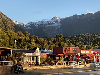
Fox Glacier, called Weheka until the 1940s, is a village on the West Coast of the South Island of New Zealand. The village is close to the eponymous Fox Glacier / Te Moeka o Tuawe.

<span class="mw-page-title-main">Arthur's Pass</span> Settlement in Canterbury, New Zealand

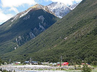
Arthur's Pass, previously called Camping Flat then Bealey Flats, and for some time officially Arthurs Pass, is a township in the Southern Alps of the South Island of New Zealand, located in the Selwyn district. It is a popular base for exploring Arthur's Pass National Park.

<span class="mw-page-title-main">The Hermitage Hotel</span> Hotel in Mount Cook Village, New Zealand

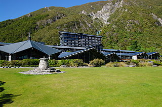
The Hermitage Hotel in Mount Cook Village, New Zealand, is a hotel located inside the Aoraki / Mount Cook National Park, 65 kilometres (40 mi) north of Twizel. The current building dates from 1958 and forms the main part of Mount Cook Village, being the only large building. Along with a nearby lodge and motels, the hotel trades as Aoraki Mt Cook Alpine Village and is owned by Trojan Holdings.

<span class="mw-page-title-main">Hooker Valley Track</span> Walking path in the Canterbury Region, New Zealand

The Hooker Valley Track is the most popular short walking track within the Aoraki / Mount Cook National Park in New Zealand. At only 5 kilometres (3.1 mi) length and gaining only about 100 m (330 ft) in height, the well formed track can be walked by tourists with a wide range of level of fitness.

<span class="mw-page-title-main">Geography of the South Island</span>

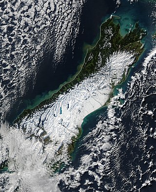
The South Island, with an area of 150,437 km2 (58,084 sq mi), is the largest landmass of New Zealand; it contains about one-quarter of the New Zealand population and is the world's 12th-largest island. It is divided along its length by the Southern Alps, the highest peak of which is Aoraki / Mount Cook at 3,724 metres (12,218 ft), making it 9th-highest island, with the high Kaikōura Ranges to the northeast. There are eighteen peaks of more than 3,000 metres (9,800 ft) in the South Island. The east side of the island is home to the Canterbury Plains while the West Coast is famous for its rough coastlines such as Fiordland, a very high proportion of native bush, and Fox and Franz Josef Glaciers. The dramatic landscape of the South Island has made it a popular location for the production of several films, including The Lord of the Rings trilogy and The Chronicles of Narnia: The Lion, the Witch and the Wardrobe. It lies at similar latitudes to Tasmania, and parts of Patagonia in South America.

References

  1. 1 2 3 "ArcGIS Web Application". statsnz.maps.arcgis.com. Retrieved 8 February 2024.
  2. 1 2 "Aotearoa Data Explorer". Statistics New Zealand . Retrieved 26 October 2024.
  3. "Aoraki/Mount Cook, Canterbury - NZ Topo Map". NZ Topo Map. Land Information New Zealand . Retrieved 25 August 2016.
  4. 1 2 3 "Aoraki/Mount Cook Village: Long-term Community Plan", Department of Conservation
  5. Charlie Mitchell (12 August 2016). "Mt Cook: The tiny school in the shadow of the mountain". Stuff . Retrieved 25 August 2016.
  6. "Ngāi Tahu Claims Settlement Act 1998".
  7. 2018 Census place summary: Mackenzie Lakes
  8. 1 2 "Statistical area 1 dataset for 2018 Census". Statistics New Zealand. March 2020. 7027549.
  9. "The Hermitage" official website
  10. "Aoraki/Mount Cook village walking tracks". Department of Conservation. Retrieved 25 August 2016.
  11. "Aoraki/Mount Cook National Park visitor centre", Department of Conservation
  12. "...hunting for tahr and chamois is permitted all year round in Aoraki/Mount Cook National Park..."
  13. "Huts by region: Aoraki/Mount Cook area", Department of Conservation
  14. "Youth hostel closures in Tekapo and Aoraki/Mt Cook a double blow for Mackenzie District". Stuff. 25 November 2021. Retrieved 26 November 2021.
  15. "Climate data and activities". NIWA. Archived from the original on 20 May 2024. Retrieved 20 May 2024.
  16. "CliFlo -The National Climate Database (Agent numbers: 4591, 4593, 18128)". NIWA. Retrieved 21 July 2024.
  17. "CliFlo -The National Climate Database (Agent number: 41165)". NIWA. Retrieved 21 July 2024.
  18. "CliFlo – National Climate Database : Mueller Hut Ews". NIWA. Retrieved 19 May 2024.
  19. Education Counts: Aoraki Mount Cook School
  20. "New Zealand Schools Directory". New Zealand Ministry of Education. Retrieved 1 January 2025.
  21. "About". Aoraki Mount Cook School. Retrieved 22 November 2021.