
The Delaware Water Gap is a water gap on the border of the U.S. states of New Jersey and Pennsylvania where the Delaware River cuts through a large ridge of the Appalachian Mountains. The gap constitutes the southern portion of the Delaware Water Gap National Recreation Area, which is used primarily for recreational purposes, such as rafting, canoeing, swimming, fishing, hiking, and rock climbing.

Bragg Creek is a hamlet in southern Alberta under the jurisdiction of Rocky View County in Division No. 6.

Bear Mountain State Park is a 5,205-acre (21.06 km2) state park located on the west bank of the Hudson River in Rockland and Orange counties, New York. The park offers biking, hiking, boating, picnicking, swimming, cross-country skiing, cross-country running, sledding and ice skating. It also includes several facilities such as the Perkins Memorial Tower, the Trailside Museum and Zoo, the Bear Mountain Inn, a merry-go-round, pool, and a skating rink. It also hosts the Bear Mountain Circle, where the historic Palisades Interstate Parkway and Bear Mountain Bridge meet. It is managed by the Palisades Interstate Park Commission, which is overseen by the State of New York.
The Afan Forest Park is a 48-square-mile (120 km2) forest park in Britain. It is set in the Afan Valley in Neath Port Talbot, in south Wales. It is well known for its mountain biking and hiking or hillwalking trails. It is situated seven miles (11 km) from Junction 40 of the M4.
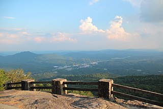
Black Rock Mountain State Park is a 1,743-acre (705 ha) Georgia, United States, state park west of Mountain City in Rabun County, in the Blue Ridge Mountains. It is named after its sheer cliffs of dark-colored biotite gneiss. Astride the Eastern Continental Divide at an elevation of 3,640 feet (1,110 m), the park provides many scenic overlooks and 80-mile (130 km) vistas of the southern Appalachian Mountains. On a clear day, four states are visible: Georgia, North Carolina, South Carolina, and Tennessee. In addition to Black Rock Mountain itself, the park includes four other peaks over 3,000 feet (910 m) in elevation, making it the state's highest state park. As of 2019, it was open to visitors year round.
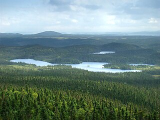
Terra Nova National Park is located on the east coast of Newfoundland in the Canadian province of Newfoundland and Labrador, along several inlets of Bonavista Bay. The park takes its name from the Latin name for Newfoundland; it is also the original Portuguese name given to the region.

The North Shore Mountains are a mountain range overlooking Vancouver in British Columbia, Canada. Their southernmost peaks are visible from most areas in Vancouver and form a distinctive backdrop for the city.

Jonathan Dickinson State Park is a Florida State Park and historic site located in Martin County, Florida, between Hobe Sound and Tequesta. The park includes the Elsa Kimbell Environmental Education and Research Center and a variety of natural habitats: sand pine scrub, pine flatwoods, mangroves, and river swamps. The Loxahatchee River, designated a National Wild and Scenic River in 1985, runs through the park. The park is also along the Ocean to Lake Trail. The park is at 16450 S.E. Federal Highway, Hobe Sound. The park is well known for its Camp Murphy Mountain Bike Trails.

Kikomun Creek Provincial Park is a provincial park in British Columbia, Canada.

Koksilah River Provincial Park is a provincial park in British Columbia, Canada.

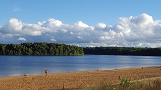
Lake Bemidji State Park is a state park of Minnesota, United States, on the north shore of 6,765-acre (27.38 km2) Lake Bemidji. The northern half of the park preserves a spruce-tamarack bog. A district of National Park Service rustic structures built by the Civilian Conservation Corps and National Youth Administration in the 1930s is on the National Register of Historic Places. The park is located 5 miles (8.0 km) north of the city of Bemidji.

Scouting and Guiding in Alberta has a long history, from the 1900s to the present day, serving thousands of youth in programs that suit the environment in which they live.
Fort Custer State Recreation Area is a 3,033-acre (12 km2) State Recreation Area located between Battle Creek and Kalamazoo, Michigan. The area features lakes, the Kalamazoo River, over 25 miles of multi-use trails, second growth oak barrens and dry-mesic southern (oak-hickory) forests.
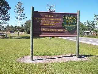
The Little Big Econ State Forest is a state forest in the U.S. state of Florida. The 5,048 acres (20.43 km2) forest is located in Central Florida, 3.3 miles (5.3 km) east of the downtown Oviedo, on Florida Country Road 426 with forest office on Snow Hill Road in Geneva, Florida. The Kilbee Tract is a smaller non-contiguous section of the park located east of the main forest, along Saint Johns River, the longest river in the state.

Kickapoo State Recreation Area is an Illinois state park on 2,842 acres (1,150 ha) in Vermilion County, Illinois, United States. Located between Oakwood, Illinois and Danville, Illinois, this park is easily accessible through route I-74. It is 28 miles (45 km) away from the University of Illinois at Urbana-Champaign and 95 miles (153 km) from Indianapolis. According to the Illinois Department of Natural Resources, the name Kickapoo originated from the Kickapoo village that once existed near the junction of the Salt Fork and Middle Fork branches of the Vermilion River. After Europeans settled in the area and displaced the Native Americans, the Europeans began to dig wells to harvest salt from salt springs, called salines. In the early 20th century the land was then strip-mined for coal. Kickapoo State Park was the first park in the United States to be located on strip-mined land. The state of Illinois purchased the Kickapoo State Park Area in 1939 with donation money from Danville residents and the land has since recovered from the extraction of these resources.

Elijah Bristow State Park is a state park in the U.S. state of Oregon, administered by the Oregon Parks and Recreation Department. It has more than 10 miles (16 km) of well-maintained trails along ponds, wetlands, meadows, and the Middle Fork Willamette River, and through forests of broadleaf and evergreen trees. The trails are open to horses, hikers, and mountain bikers, and there is a separate equestrian staging area popular with riding clubs.

Outdoor recreation or outdoor activity refers to recreation engaged in out of doors, most commonly in natural settings. The activities that encompass outdoor recreation vary depending on the physical environmental they are being carried out in. These activities can include fishing, hunting, backpacking, and horseback riding — and can be completed individually or collectively. Outdoor recreation is a broad concept that encompasses a varying range of activities and landscapes.

Mohican State Park is a 1,110-acre (450 ha) public recreation area located on the south shore of Pleasant Hill Lake, five miles (8.0 km) south of Loudonville in Ashland County, Ohio, United States. The state park is located along Ohio SR 3 and Ohio SR 97 and is surrounded by the 4,525-acre (1,831 ha) Mohican-Memorial State Forest. The Clear Fork of the Mohican River flows through the park carving a narrow gorge and joins the Black Fork about a half-mile east of the park to form the Mohican River. The park is open for year-round recreation including camping, hiking, boating, mountain biking, fishing, and picnicking.

Granville State Forest is a Massachusetts state park located in the towns of Granville and Tolland in the southern Berkshire Hills along the state's southern border with Connecticut. The park is managed by the Department of Conservation and Recreation (DCR). It is adjacent to Connecticut's Tunxis State Forest.

The Kabetogama State Forest is a state forest located in Koochiching and Saint Louis counties, Minnesota, United States. The forest borders the Superior National Forest and the Boundary Waters Canoe Area Wilderness to the east, the Sturgeon River State Forest to the south, the Nett Lake Indian Reservation to the west, and Voyageurs National Park to the north. The forest is managed by the Minnesota Department of Natural Resources.
