Related Research Articles

The Waimakariri River is one of the largest rivers in Canterbury, on the eastern coast of New Zealand's South Island. It flows for 151 kilometres (94 mi) in a generally southeastward direction from the Southern Alps across the Canterbury Plains to the Pacific Ocean.
The Opuha Dam is located on the Opuha River, a tributary of the Ōpihi River in South Canterbury, New Zealand. The dam is used for water storage for farming irrigation and provides 7.7 MW of electricity to New Zealand's national grid. The site has been identified as an Important Bird Area by BirdLife International because it supports breeding colonies of the endangered black-billed gull.
The Opuha River is in Canterbury, New Zealand. A tributary of the Ōpihi River, its two branches flow southeast for 35 kilometres (22 mi) before joining the larger river between Geraldine and Fairlie.

The Ōpihi River flows through south Canterbury, in New Zealand's South Island. It has been identified as an Important Bird Area by BirdLife International because it supports breeding colonies of the endangered black-billed gull.

South Canterbury is the area of the Canterbury Region of the South Island of New Zealand bounded by the Rangitata River in the north and the Waitaki River to the south. The Pacific Ocean and ridge of the Southern Alps form natural boundaries to the east and west respectively. Though the exact boundaries of the region have never been formalised, the term is used for a variety of government agencies and other entities. It is one of four traditional sub-regions of Canterbury, along with Mid Canterbury, North Canterbury, and Christchurch city.
The Hinds River is a river in the Canterbury region of New Zealand. Its north and south branches drain the eastern flank of the Moorhouse Range, part of the Southern Alps, and their confluence is near Anama and Mayfield. The river then flows across the Canterbury Plains towards the Pacific Ocean, passing through the small town of Hinds along the way. In Hinds, State Highway 1 and the Main South Line railway cross the river. The river's mouth is located between the localities of Longbeach and Lowcliffe.
Grey District Council is the territorial authority for the Grey District of New Zealand.
The Hae Hae Te Moana River is a river in the Canterbury region of New Zealand. It originates in the Four Peaks Range of the Southern Alps, with a North Branch and South Branch merging to the north of Pleasant Valley. The river runs south-east to join the Waihi River near Winchester. The combined river is called the Temuka River, which flows past Temuka to join the Ōpihi River shortly before it runs into the Canterbury Bight.

The Harman River is a river of New Zealand. It starts in the Browning Range of the Southern Alps and becomes the Arahura River, which flows into the Tasman Sea north of Hokitika.
The North Opuha River is a river of the south Canterbury region of New Zealand's South Island. It flows south from its sources in the Sherwood Range, and drains into the northern end of Opuha Lake, 15 kilometres (9 mi) north of Fairlie.
Waimakariri District Council is the territorial authority for the Waimakariri District of New Zealand.

Timaru District Council is the territorial authority for the Timaru District of New Zealand.
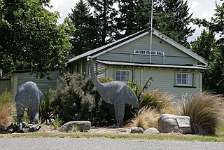
Alford Forest is a location in Ashburton District, Canterbury, New Zealand.

Ashburton District Council is the territorial authority for the Ashburton District of New Zealand. The council consists of the mayor of Ashburton and nine ward councillors.

Lauriston is a lightly populated locality in the Canterbury region of New Zealand's South Island. It is situated on the Canterbury Plains south of the Rakaia River, some 20 kilometres (12 mi) inland from Rakaia. It was named after one of its pioneer settlers with the name of Laurie.

Opihi is a small rural district located in the Timaru District, New Zealand. It is located just north of Pleasant Point and just to the west of Temuka. Richard Pearse lived in the area and conducted his 1903 experiments in powered flight along the banks of the Ōpihi River.
Raincliff is a small rural community split across the Mackenzie and Timaru Districts, New Zealand. It is located north-west of Pleasant Point and east of Fairlie. The Ōpihi River and Opuha River runs through the area. Popular camping sites include Raincliff Scout Camp, Pioneer Park, and Raincliff Youth Camp.
Waimate District Council is the territorial authority for the Waimate District of New Zealand.

The Two Thumb Range is a range of mountains in the Canterbury Region of New Zealand's South Island. It is located to the east of Lake Tekapo and has several peaks which rise to around 2,500 metres (8,200 ft). The southern end of the range contains one of Canterbury's main skifields, Mount Dobson.
Bortons is a small settlement on the southern bank of the Waitaki River in New Zealand's South Island. It is located on SH 83, 7 km east of Duntroon.
References
- ↑ Reed New Zealand atlas (2004) Auckland: Reed Publishing. Map 87. ISBN 0 7900 0952 8
44°09′35″S171°00′20″E / 44.15972°S 171.00556°E
| | This Canterbury Region-related geography article is a stub. You can help Wikipedia by expanding it. |