
Queenstown is a resort town in Otago in the south-west of New Zealand's South Island. It is the seat and largest town in the Queenstown-Lakes District.

Aoraki / Mount Cook National Park is a national park located in the central-west of the South Island of New Zealand. It was established in October 1953 and takes its name from the highest mountain in New Zealand, Aoraki / Mount Cook. The area of the park is 707 km2 (273 sq mi), and it shares a border with Westland Tai Poutini National Park along the Main Divide of the Southern Alps. The national park consists of reserves that were established as early as 1885 to protect the area's significant landscape and vegetation. Glaciers cover 40% of the park, including the county's largest glacier, Haupapa / Tasman Glacier. In 1990, the park was included in the area designated as the Te Wāhipounamu World Heritage Site. The park is managed by the Department of Conservation (DOC) alongside Ngāi Tahu, the iwi who are mana whenua in the region.

Katrina and the Waves were a British rock band formed in Cambridge in 1981, widely known for their 1985 hit "Walking on Sunshine". They also won the 1997 Eurovision Song Contest with the song "Love Shine a Light".

Waipoua Forest is a forest, on the west coast of the Northland Region of New Zealand's North Island. It preserves some of the best examples of kauri forest remaining in New Zealand. It is notable for having two of the largest living kauri trees, Tāne Mahuta and Te Matua Ngahere.

Paparoa National Park is on the west coast of the South Island of New Zealand. The park was established in 1987 and encompasses 430 km2 (170 sq mi). The park ranges from or near the coastline to the peaks of the Paparoa Range. A separate section of the park lies to the north and is centred at Ananui Creek. The park protects a limestone karst area. The park contains several caves, of which Metro Cave / Te Ananui Cave is a commercial tourist attraction. The majority of the park is forested with a wide variety of vegetation. The park was the site of the 1995 Cave Creek disaster where fourteen people died as a result of the collapse of a scenic viewing platform.

Cliff Curtis is a New Zealand actor. His film credits include Once Were Warriors (1994), Three Kings (1999), Blow (2001), Training Day (2001), Whale Rider (2002), Collateral Damage (2002), Sunshine, Live Free or Die Hard, Push, Crossing Over, Colombiana (2011), The Dark Horse (2014), for which he won the Asia Pacific Screen Award for Best Performance by an Actor, and Doctor Sleep (2019), also portraying James "Mac" Mackreides in The Meg (2018) and Meg 2: The Trench (2023) and Tonowari in Avatar: The Way of Water (2022) and Avatar 3 (2025). Curtis had television series roles on NBC's Trauma and ABC's Body of Proof and Missing. From 2015 to 2017, he portrayed Travis Manawa on the AMC horror drama series Fear the Walking Dead.

Oxford is a small town serving the farming community of North Canterbury, New Zealand. It is part of the Waimakariri District and is a linear town, approximately 2 kilometres (1.2 mi) long. Oxford has won awards for the most beautiful village and the most beautiful toilet.

Carina is an eastern suburb in the City of Brisbane, Queensland, Australia. In the 2021 census, Carina had a population of 11,678 people.

Mini is a British automotive brand founded in Oxford in 1969, owned by German multinational automotive company BMW since 2000, and used by them for a range of small cars assembled in the United Kingdom, Austria, Netherlands and Germany. The word Mini has been used in car model names since 1959, and in 1969 it became a brand in its own right when the name "Mini" replaced the separate "Austin Mini" and "Morris Mini" car model names. BMW acquired the brand in 1994 when it bought Rover Group, which owned Mini, among other brands.

Albany Creek is a southern suburb in the City of Moreton Bay, Queensland, Australia. In the 2021 census, Albany Creek had a population of 16,385 people.
NZ Transport Agency Waka Kotahi (NZTA) is a New Zealand Crown entity tasked with promoting safe and functional transport by land, including the responsibility for driver and vehicle licensing, and administering the New Zealand state highway network. Waka Kotahi means 'one vessel' and is intended to convey the concept of "travelling together as one".

Remutaka Forest Park is a protected area near Wellington, New Zealand. Popular access points are south of Wainuiomata and in the upper Hutt Valley. The park covers 220 square kilometres (85 sq mi), encompassing the Catchpool Valley and the Ōrongorongo Valley at the southern end of the Remutaka Range. Established in 1972, the park contains several short walks and six huts that can be booked and accessed by longer bush tramps. The park is one part of several local conservation areas, as it borders the Pakuratahi Forest and the Tararua Range.

Wentworth Falls is a three-tiered waterfall fed by the Jamison Creek, near the town of Wentworth Falls in the Blue Mountains region of New South Wales, Australia. The falls are accessible via the National Pass Walking Trail and the Overcliff/Undercliff Walk. The total height of the waterfall is 187 metres (614 ft).

Kimbra Lee Johnson, known mononymously as Kimbra, is a New Zealand singer and songwriter. Known for mixing pop with R&B, jazz and rock musical elements, her accolades include four ARIA Music Awards, two Grammy Awards and seven New Zealand Music Awards.
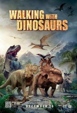
Walking with Dinosaurs is a 2013 live-action/animated family film about dinosaurs set in the Late Cretaceous period, 70 million years ago. The production features animated dinosaurs in live-action settings with actors John Leguizamo, Justin Long, Tiya Sircar, and Skyler Stone providing voice-overs for the main characters. It was directed by Neil Nightingale and Barry Cook from a screenplay by John Collee. In the film, an underdog dinosaur named Patchi must find his courage to become the leader of his herd as well as become a hero for the ages.

The Mini supermini range, marketed under various names such as Mini Cooper, Mini Hatch, Mini Hardtop, Mini One, and Mini John Cooper Works, are a family of retro-styled three-door hatchback, two-door convertible, and five-door hatchback. The range was introduced in July 2001, following the acquisition of the Mini brand by German automaker BMW.

Jesse Cooper, known under the pseudonym Mt Eden, is a New Zealander electronic music artist based in Auckland. Popular tracks include "Sierra Leone" – a remix of Freshlyground's "I'd Like" – and remixes of Delerium's "Silence" as well as Lisa Miskovsky's "Still Alive".
"Walking on Air" is a song recorded by American singer Katy Perry for her fourth studio album, Prism (2013), included as its fourth track. It was released to digital retailers on September 30, 2013, by Capitol Records, as the record's second promotional single, following the release of "Dark Horse". The song was part of a poll promoted by Pepsi, along with "Dark Horse", where fans could vote for which song they wanted to become the first promotional single from Prism. Inspired by CeCe Peniston and Crystal Waters, "Walking on Air" is a deep house and disco song influenced by 1990s Eurodance.
Bullock Creek or Punungairo is a river valley in the Paparoa National Park, located just north of Punakaiki on the West Coast of New Zealand. It includes a rare and nationally significant polje, a large, flat-floored depression within karst limestone. The Bullock Creek polje is New Zealand's only example of this type of landform.

The Fenian Track is a historic walking track in Kahurangi National Park, in the West Coast Region of New Zealand. The track was originally constructed as a bridle track, to provide improved access to a gold mining site in Fenian Creek. Gold was discovered in the creek in the 1860s, but the bulk of the West Coast gold rush was happening at more accessible claims further south, so it took nearly twenty years for mining to begin. Construction of the path began at Market Cross, Karamea, in 1876, but it was not completed all the way to Fenian Creek until 1904. Returns from gold mining here were poor; although mining revived in the 1930s during the Great Depression, even with government assistance it was not a profitable claim.

