
Kaiapoi is a town in the Waimakariri District of the Canterbury region, in the South Island of New Zealand. The town is located approximately 17 kilometres north of central Christchurch, close to the mouth of the Waimakariri River. It is considered a satellite town of Christchurch and is part of the Christchurch functional urban area. The town is named after the nearby Kaiapoi Pā.

Rangiora is the largest town and seat of the Waimakariri District, in Canterbury, New Zealand. It is 29 kilometres (18 mi) north of Christchurch, and is part of the Christchurch metropolitan area. With an estimated population of 19,400, Rangiora is the 30th largest urban area in New Zealand, and the fifth-largest in the Canterbury region.

The Canterbury Plains are an area in New Zealand centred in the Mid Canterbury, to the south of the city of Christchurch in the Canterbury region. Their northern extremes are at the foot of the Hundalee Hills in the Hurunui District, and in the south they merge into the plains of North Otago beyond the Waitaki River. The smaller Amuri Plain forms a northern extension of the plains.

The Waimakariri River is one of the largest rivers in Canterbury, on the eastern coast of New Zealand's South Island. It flows for 151 kilometres (94 mi) in a generally southeastward direction from the Southern Alps across the Canterbury Plains to the Pacific Ocean.

Oxford is a small town serving the farming community of North Canterbury, New Zealand. It is part of the Waimakariri District and is a linear town, approximately 2 kilometres (1.2 mi) long. Oxford has won awards for the most beautiful village and the most beautiful toilet.

The Kaiapoi River is a minor river of north Canterbury, in New Zealand's South Island. Originally called the Cam River, it is a tributary of the Waimakariri River, which it joins at the larger river's estuary. The river is 16 kilometres (10 mi) long, and its drainage area is about 430 square kilometres (170 sq mi).

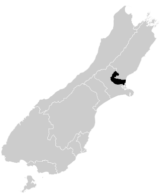
Waimakariri District is a local government district, located in the Canterbury Region of New Zealand's South Island. It is named after the Waimakariri River, which forms the district's southern boundary, separating it from Christchurch City and the Selwyn District. It is bounded in the north by the Hurunui District and in the east by the Pacific Ocean.

The Oxford Branch was a branch line railway that formed part of New Zealand's national rail network. It was located in the Canterbury region of the South Island, and ran roughly parallel with the Eyreton Branch that was located some ten kilometres south. It opened to Oxford in 1875 and survived until 1959.
The Hinds River is a river in the Canterbury region of New Zealand. Its north and south branches drain the eastern flank of the Moorhouse Range, part of the Southern Alps, and their confluence is near Anama and Mayfield. The river then flows across the Canterbury Plains towards the Pacific Ocean, passing through the small town of Hinds along the way. In Hinds, State Highway 1 and the Main South Line railway cross the river. The river's mouth is located between the localities of Longbeach and Lowcliffe.
Waimakariri is a New Zealand parliamentary electorate, formed for the 1996 election and returning one Member of Parliament to the New Zealand House of Representatives. The MP for Waimakariri is Matt Doocey of the National Party. He has held this position since the 2014 election and takes over from Kate Wilkinson, who defeated Clayton Cosgrove (Labour) in the 2011 election.

Cust is a rural village in the South Island of New Zealand. It is located in North Canterbury and comes under seat of the Waimakariri District Council. It is located approximately 16 km east of Oxford and 17 km west of Rangiora. The town is named after Sir Edward Cust, who was a member of the Canterbury Association which organised European settlement of the area around 1850. Earlier names for the town were Moeraki Downs and Middleton-on-the-Cust.
The Crow River is a river in Arthur's Pass National Park, Canterbury, New Zealand. It arises near Mount Rolleston and flows south into the Waimakariri River.
The Hapuka River is a river of Westland District, New Zealand. It flows from near The Woolsack north-west to join the Okuru and Turnbull Rivers just before they enter the Tasman Sea. The river is slow-moving and drains swampy land. There are brown trout in the lagoon area.
The Eyre River is a river in the Canterbury region of New Zealand. It arises in the Puketeraki Range and flows south-east into the Waimakariri River near Christchurch International Airport. The connection with the Waimakariri is via a diversion channel running south-west, replacing the Eyre's original easterly flow. The river is named after Edward John Eyre, the Lieutenant-Governor of New Munster from 1848 to 1853.
Canterbury's Esk River is a tributary of the Waimakariri River. It rises in the Dampier Range near Esk Head, and flows southwest on the western side of the Puketeraki Range to reach the upper Waimakariri some 20 kilometres (12 mi) north of Springfield.

The Cam River / Ruataniwha is a small river in Canterbury in the South Island of New Zealand. It is a tributary of the Kaiapoi River, itself a tributary of the Waimakariri River.
Flaxton is a small rural community in between the towns of Rangiora and Kaiapoi in the Waimakariri District, New Zealand.

Marmaduke John Dixon, known as Marmaduke or Duke Dixon, was a New Zealand farmer and mountaineer.
Marmaduke Dixon was an early settler in North Canterbury, New Zealand. He went to sea early in his life before he settled on the North bank of the Waimakariri River. An innovative farmer, he chaired a number of road boards and was a member of the Canterbury Provincial Council.

Ashley Rakahuri Regional Park is a regional park in the Canterbury Region of New Zealand's South Island. It covers 417 hectares on the banks of Ashley River / Rakahuri and Okuku River, and is operated by Environment Canterbury. The park is used for fishing, walking, swimming, cycling and family picnics.

