Loburn

Last updated

Loburn
Welcome sign in Loburn New Zealand, 2013.jpg
Welcome sign to Loburn, looking east towards Loburn School (2013).
Loburn
Coordinates: 43°15′S172°32′E / 43.250°S 172.533°E / -43.250; 172.533
Country New Zealand
Region Canterbury
Territorial authority Waimakariri District
WardRangiora-Ashley Ward
CommunityRangiora-Ashley Community
Electorates
Government
  Territorial Authority Waimakariri District Council
  Regional council Environment Canterbury
   Mayor of Waimakariri Dan Gordon
   Kaikōura MP Stuart Smith
   Te Tai Tonga MP Tākuta Ferris
Area
[2]
  Rural89.32 km2 (34.49 sq mi)
Elevation
 (Loburn Abbey Airfield) [3]
116 m (380 ft)
Population
 (June 2023) [4]
  Rural2,420
  Density27/km2 (70/sq mi)
Time zone UTC+12 (NZST)
  Summer (DST) UTC+13 (NZDT)
Postcode
7472
Area code 03

Loburn is a rural community in North Canterbury, New Zealand. It is located ten kilometres northwest of Rangiora and nearly 50 kilometres north of Christchurch.

Contents

Loburn is a small community, with no shops. Local industries include a cheese factory and orchards. Farms in the community include those raising sheep, cattle and emu. [5]

Geography

Loburn is located close to the northernmost extreme of the Canterbury Plains. It is bounded to the south and west by the Ashley and Okuku rivers, respectively. To the north it is bounded by the foothills, Mount Grey / Maukatere (933m) [6] and Mt Karetu (972m) [7] and bounded to the east by the Ashley forest.

The Loburn-Ashley fault zone is located from the northern banks of the Ashley River through to about Hodgsons road in the north, it runs parallel to the Ashley river. The Loburn fault, which runs along the south side of Hodgsons Road, is responsible for various terraced abandoned stream channels, wedge structures and scarps, notably Round Hill. [8] The topography in Loburn is generally flat with gently rolling hills, altitude gradually decreases southwards from the foothills.

Demographics

The Loburn statistical area covers 89.32 km2 (34.49 sq mi). [2] It had an estimated population of 2,420 as of June 2023, [4] with a population density of 27.09 people per km2.

Historical population
YearPop.±% p.a.
1901 [9] 537    
1996 [10] 1,032+0.69%
2001 [10] 1,197+3.01%
2006 [11] 1,338+2.25%
2013 [11] 1,941+5.46%
2018 [11] 2,175+2.30%

Loburn had a population of 2,175 at the 2018 New Zealand census, an increase of 234 people (12.1%) since the 2013 census, and an increase of 837 people (62.6%) since the 2006 census. There were 735 households, comprising 1,098 males and 1,077 females, giving a sex ratio of 1.02 males per female. The median age was 45.4 years (compared with 37.4 years nationally), with 414 people (19.0%) aged under 15 years, 339 (15.6%) aged 15 to 29, 1,149 (52.8%) aged 30 to 64, and 273 (12.6%) aged 65 or older.

Ethnicities were 95.7% European/Pākehā, 6.2% Māori, 1.4% Pasifika, 1.5% Asian, and 1.8% other ethnicities. People may identify with more than one ethnicity.

The percentage of people born overseas was 20.7, compared with 27.1% nationally.

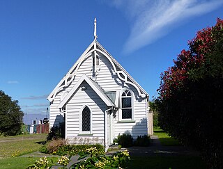
St Martins Anglican Church, Loburn St Martins Anglican Church Loburn.jpg
St Martins Anglican Church, Loburn

Although some people chose not to answer the census's question about religious affiliation, 57.4% had no religion, 32.7% were Christian, 0.3% were Hindu, 0.3% were Buddhist and 1.7% had other religions.

Of those at least 15 years old, 339 (19.3%) people had a bachelor's or higher degree, and 270 (15.3%) people had no formal qualifications. The median income was $36,900, compared with $31,800 nationally. 414 people (23.5%) earned over $70,000 compared to 17.2% nationally. The employment status of those at least 15 was that 942 (53.5%) people were employed full-time, 348 (19.8%) were part-time, and 57 (3.2%) were unemployed. [11]

Entrance to Loburn School, 2018. Loburn school.jpg
Entrance to Loburn School, 2018.

Education

Loburn has two schools.

Loburn School (est. 1869) is a decile 9 state co-educational primary school [12] with a role of 163students (as of February 2024). [13]

North Loburn School (est. 1882) is a decile 9 state co-educational primary school [14] with a role of 82students (as of February 2024). [13]

Related Research Articles

<span class="mw-page-title-main">Amberley, New Zealand</span> Town in Canterbury, New Zealand

Amberley is a town located in the Hurunui District in north Canterbury, on the east coast of the South Island of New Zealand. It is located on State Highway 1 approximately 50 km north of Christchurch. It is the seat of the Hurunui District Council. The nearest town to the north of Amberly via state highway one is Waipara (11 km) and the nearest town to the south is Leithfield (5.7 km).

<span class="mw-page-title-main">Riwaka</span> Town in Tasman, New Zealand

Riwaka is a small settlement in the Tasman District of New Zealand's South Island. It lies beside Tasman Bay / Te Tai-o-Aorere, five kilometres north of Motueka, and close to the mouth of the Riuwaka River. The land where the town is based was a swamp known as Tureauraki. Europeans first settled in Riwaka in May 1842. The Riwaka economy has been based around growing tobacco and hops.

<span class="mw-page-title-main">Springfield, New Zealand</span> Settlement in Canterbury, New Zealand

Springfield, called Kowai Pass until 1880, is a small town in the Selwyn District of Canterbury, in the South Island, of New Zealand. Springfield is situated in the foothills of the Southern Alps as the most westerly town of the Canterbury Plains. Springfield is 65 kilometres (40 mi) west of Christchurch on State Highway 73, 9.7 kilometres (6.0 mi) northwest of Sheffield and 22.7 kilometres (14.1 mi) from Darfield. It is located close to Porters Ski Area, Mount Cheeseman, Broken River, Temple Basin and Craigieburn ski fields. Springfield has a long association with the Midland railway line.

<span class="mw-page-title-main">Tōtara Park</span> Suburb of Upper Hutt City, New Zealand

Tōtara Park is a suburb of Upper Hutt, New Zealand, located 2 km northeast of the city centre. It is accessed via the Tōtara Park Bridge which crosses the Hutt River, connecting it to State Highway 2 and the main Upper Hutt urban area. It was popular in the 1970s and 1980s for families moving into the Upper Hutt area.

<span class="mw-page-title-main">Fernside, New Zealand</span> Rural area in Canterbury, New Zealand

Fernside is a small rural community in the Waimakariri District, New Zealand. In 1901, Fernside had a population of 550. As of the 2006 New Zealand census, Fernside has a population of 1491.

<span class="mw-page-title-main">Frasertown</span> Settlement in Hawkes Bay Region, New Zealand

Frasertown is a small settlement in the northern Hawke's Bay Region of New Zealand's eastern North Island.

Tutira is a village to the north of Napier and is part of the Hawke's Bay Region in New Zealand's North Island. It is located on State Highway 2 between Wairoa and Napier.
<span class="mw-page-title-main">Waikuku</span> Town in Canterbury, New Zealand

Waikuku is a small town in the Canterbury region of New Zealand, which sits 28 km north of central Christchurch. Waikuku lies 11.8 km (7.3 mi) south of Leithfield on state highway 1 and 3 km (1.9 mi) north of Woodend. In 1901 there were 86 people resident in Waikuku according to that year's census. Waikuku settlement had a population of 156 people at the time of the 2018 Census. It is popular with both those that commute into work in Christchurch each day and with owners of holiday houses. Waikuku was home to rope and twine works. This business started off using flax from local swamps. It closed in 1987. The nearby sandy beach and pine forests are popular with surfers, swimmers, campers and horse-riders, and the large estuary of the Ashley River hosts many species of birds.

Karetu is a community in the Northland Region of the North Island of New Zealand. Kawakawa is to the west, and Waikare is northeast. The Karetu River flows from the Russell Forest in the southeast through Karetu, and joins the Kawakawa River shortly before it flows into the Bay of Islands.

<span class="mw-page-title-main">Woodend, New Zealand</span> Town in Canterbury, New Zealand

Woodend is a town in the Waimakariri District, in the Canterbury Region of the South Island of New Zealand. It may have been named because it was on the edge of what was then called the Maori Bush, or after an early settler, Thomas Wooding. It is situated with both the Waimakariri and Ashley / Rakahuri Rivers running either side. Woodend is 6.6 kilometres north of Kaiapoi and 6.3 kilometres to the east of Rangiora. Woodend is within walking distance of the town of Pegasus.

<span class="mw-page-title-main">Cust, New Zealand</span> Town in Canterbury, New Zealand

Cust is a rural village in the South Island of New Zealand. It is located in North Canterbury and comes under seat of the Waimakariri District Council. It is located approximately 16 km east of Oxford and 17 km west of Rangiora. The town is named after Sir Edward Cust, who was a member of the Canterbury Association which organised European settlement of the area around 1850. Earlier names for the town were Moeraki Downs and Middleton-on-the-Cust.

<span class="mw-page-title-main">Ashley, New Zealand</span> Settlement in Canterbury, New Zealand

Ashley is a small town in North Canterbury, in the South Island of New Zealand. It used to have a railway station on the Main North Line that runs through the village.

<span class="mw-page-title-main">Ongaonga, New Zealand</span> Settlement in Hawkes Bay Region, New Zealand

Ongaonga is a village in Central Hawkes Bay District of New Zealand's North Island. It is located 20 kilometres west of Waipawa and a similar distance from Waipukurau.
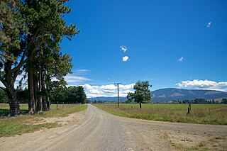
<span class="mw-page-title-main">Okuku, New Zealand</span> Locality in Canterbury, New Zealand

Okuku is a small farming community located in North Canterbury, New Zealand, lying 20 kilometres northwest of Rangiora. Okuku consists of a mix of flat and undulating farmland, and river beds that drain a catchment area in the foothills to the north. Okuku is bounded to the south by the Ashley River / Rakahuri, to the east by the Okuku River, and to the west by the Garry River. Mount Thomas is the highest point at a height of 1023m.

Hexton is a village and rural area in the Gisborne District of New Zealand's North Island. It is located north-west of Gisborne City, and includes the settlements of Makauri and Waerengaahika.

Pukeatua is a rural farming community in Waipa District and Waikato region of New Zealand's North Island. It is situated at the south-western foot of the Pukeatua hill, of the Maungatautari mountain range.

<span class="mw-page-title-main">Tuai</span> Settlement in Hawkes Bay Region, New Zealand

Tuai is a village and rural community located around Lake Whakamarino, in the Wairoa District of the Hawke's Bay Region, on New Zealand's North Island.

Omakere is a farming settlement in the Central Hawke's Bay District and Hawke's Bay Region of New Zealand's North Island. It is located east of Waipawa.

Maihiihi is a rural community in the Ōtorohanga District and Waikato region of New Zealand's North Island.

References

  1. "Find my Electorate | Electoral Commission". Elections.org.nz. Archived from the original on 8 February 2013. Retrieved 1 February 2014.
  2. 1 2 "ArcGIS Web Application". statsnz.maps.arcgis.com. Retrieved 23 December 2023.
  3. Loburn Abbey Airfield Flyin (16 February 2013). "Loburn Abbey fly-in". Aircraft-r-us.com. Retrieved 1 February 2014.
  4. 1 2 "Population estimate tables - NZ.Stat". Statistics New Zealand . Retrieved 25 October 2023.
  5. Cross, Tracy-Anne et al. 2005 p.46 North Canterbury: An Analysis of the Current Economic Base of the Region Archived 14 October 2008 at the Wayback Machine
  6. "Mount Grey/Maukatere, Canterbury". topomap.co.nz.
  7. "Mount Karetu, Canterbury". topomap.co.nz.
  8. "Paleoseismicity of the Ashley and Loburn Faults, North Canterbury, New Zealand. (pages 42-54)" (PDF). Earthquake Commission Research Foundation. Retrieved 16 December 2013.
  9. Cyclopedia Company Limited. "Loburn | NZETC". Nzetc.victoria.ac.nz. Retrieved 1 February 2014.
  10. 1 2 "Loburn Community Profile(published)". .stats.govt.nz. 30 May 2003. Retrieved 1 February 2014.
  11. 1 2 3 4 "Statistical area 1 dataset for 2018 Census". Statistics New Zealand. March 2020. Loburn (313400). 2018 Census place summary: Loburn
  12. "Loburn School Website". Loburn.ultranet.school.nz. 17 December 2013. Archived from the original on 13 November 2013. Retrieved 1 February 2014.
  13. 1 2 "New Zealand Schools Directory". New Zealand Ministry of Education. Retrieved 14 March 2024.
  14. "North Loburn School Website". Northloburn.school.nz. Retrieved 1 February 2014.