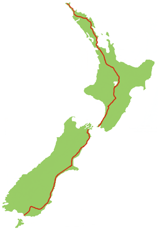
The New Zealand state highway network is the major national highway network in New Zealand. Nearly 100 roads in the North and South Islands are state highways. All state highways are administered by the NZ Transport Agency.

Kaiapoi is a town in the Waimakariri District of the Canterbury region, in the South Island of New Zealand. The town is located approximately 17 kilometres north of central Christchurch, close to the mouth of the Waimakariri River. It is considered a satellite town of Christchurch and is part of the Christchurch functional urban area. The town is named after the nearby Kaiapoi Pā.

Rangiora is the largest town and seat of the Waimakariri District, in Canterbury, New Zealand. It is 29 kilometres (18 mi) north of Christchurch, and is part of the Christchurch metropolitan area. With an estimated population of 19,600, Rangiora is the 30th largest urban area in New Zealand, and the fifth-largest in the Canterbury region.

Waimakariri District is a local government district, located in the Canterbury Region of New Zealand's South Island. It is named after the Waimakariri River, which forms the district's southern boundary, separating it from Christchurch City and the Selwyn District. It is bounded in the north by the Hurunui District and in the east by the Pacific Ocean.

State Highway 1 is the longest and most significant road in the New Zealand road network, running the length of both main islands. It appears on road maps as SH 1 and on road signs as a white number 1 on a red shield, but it has the official designations SH 1N in the North Island, SH 1S in the South Island.
The Eyreton Branch was a branch line railway that formed part of New Zealand's national rail network. Located in the Canterbury region of the South Island, it left the Main North Line in Kaiapoi and was built a mere ten kilometres south of the Oxford Branch. It opened in 1875 and operated until 1954, except for the first portion, which remained open until 1965.

The Oxford Branch was a branch line railway that formed part of New Zealand's national rail network. It was located in the Canterbury region of the South Island, and ran roughly parallel with the Eyreton Branch that was located some ten kilometres south. It opened to Oxford in 1875 and survived until 1959.
Rail transport in Christchurch, the largest city on New Zealand's South Island, consists of two main trunk railway lines intersecting in the suburb of Addington, carrying mainly long-haul freight traffic but also two long distance tourist-oriented passenger trains. The two lines are the Main North Line and Main South Line, collectively but unofficially known as the South Island Main Trunk Railway. There is a heritage line at the Ferrymead Historic Park that is operated with steam, electric, and diesel motive power hauling tourist-oriented services.
State Highway 78 is a New Zealand State Highway connecting central Timaru with its port. It holds the record for New Zealand's shortest state highway, with a length of just over 900 metres (3,000 ft).

Woodend is a town in the Waimakariri District, in the Canterbury Region of the South Island of New Zealand. It may have been named because it was on the edge of what was then called the Maori Bush, or after an early settler, Thomas Wooding. It is situated with both the Waimakariri and Ashley / Rakahuri Rivers running either side. Woodend is 6.6 kilometres north of Kaiapoi and 6.3 kilometres to the east of Rangiora. Woodend is within walking distance of the town of Pegasus.
The Christchurch Southern Motorway is the main southern route into and out of Christchurch, New Zealand. The motorway forms part of State Highway 1 and State Highway 76.
State Highway 93 (SH 93) is a New Zealand State Highway connecting the Southland township of Mataura with the Western Otago town of Clinton. This provides a slightly quicker route between the cities of Dunedin and Invercargill, as it bypasses the town of Gore. It is roughly 43.2 km long.
The Christchurch Northern Motorway is the main northern route into and out of Christchurch, New Zealand. The motorway forms part of State Highway 1 and State Highway 74.
State Highway 40 was part of the New Zealand state highway network before it was revoked in 1991–92.
State Highway 91 (SH 91) was part of the New Zealand state highway network before briefly becoming part of SH 92 in 1990–91. It ran for 13 kilometres through South Otago in the southern South Island. SH 92 itself had its status revoked a year later.

Papanui railway station served the suburb of Papanui in northern Christchurch, New Zealand. It was on the Main North Line between the stations of Bryndwr and Styx, 5.3 kilometres (3.3 mi) north of Addington Junction. The station handled freight and passenger traffic from when it opened in 1872 until closing in the late 20th century, and from 1880 was the site of an interchange between passenger rail and trams until the 1930s.

Ashley Rakahuri Regional Park is a regional park in the Canterbury Region of New Zealand's South Island. It covers 417 hectares on the banks of Ashley River / Rakahuri and Okuku River, and is operated by Environment Canterbury. The park is used for fishing, walking, swimming, cycling and family picnics.


