
Tokomaru Bay is a small beachside community on the remote East Coast of New Zealand's North Island. It is 91 km north of Gisborne, on State Highway 35, and close to Mount Hikurangi. The district was originally known as Toka-a-Namu, which refers to the abundance of sandflies. Over the years the name was altered to Tokomaru Bay.
Glenavy is a small town in the South Island of New Zealand. It is located at the southern extreme of the Canterbury region on the alluvial fan of the Waitaki River, three kilometres from the river's outflow into the Pacific Ocean.

Cape Runaway is the eastern extremity of the Bay of Plenty in New Zealand's North Island. It is located 157 kilometres northeast off Whakatāne and 65 kilometres west of East Cape.

Ōhura is a small town in the west of the North Island of New Zealand. It is located to the west of Taumarunui in the area known as the King Country, in inland Manawatū-Whanganui. It lies on the banks of the Mangaroa Stream, a tributary of the Ōhura River which is a tributary of the Whanganui River.

Reporoa is a rural community in Rotorua Lakes within the Waikato region of New Zealand's North Island.
Rahotu is a community in the west of Taranaki, in the North Island of New Zealand. It is located on State Highway 45, 16 kilometres north of Ōpunake and 11 km south of Warea.
Kaingaroa is a locality in the Far North District of New Zealand. It lies on State Highway 10 north-east of Awanui and Kaitaia, and south-west of Karikari Peninsula.
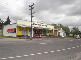
Broadwood is a town about 25 km to the north of the north side of the Hokianga harbour, in Northland, New Zealand. Herekino is 21 km to the west, and Mangamuka Bridge is the same distance to the east.
Panguru is a community in the northern Hokianga harbour, in Northland, New Zealand. The Whakarapa Stream flows from the Panguru Range in the Warawara Forest to the west, through Panguru and into the Hokianga.
Rawhiti is a small beachfront town about 27km from Russell in the Bay of Islands of New Zealand.
Maromaku is a locality in the Northland Region of the North Island of New Zealand. Kawakawa is north, and Towai is southeast. State Highway 1 runs past Maromaku to the north, and the North Auckland Line runs through it.
Karetu is a community in the Northland Region of the North Island of New Zealand. Kawakawa is to the west, and Waikare is northeast. The Karetu River flows from the Russell Forest in the southeast through Karetu, and joins the Kawakawa River shortly before it flows into the Bay of Islands.
Rawhitiroa is a locality situated in South Taranaki, New Zealand. It is positioned approximately 6.5 km east of Eltham.

The Pines Beach is a small town situated roughly 4 km east of Kaiapoi in the Canterbury region of the South Island of New Zealand. It is 1 km north of the mouth of the Waimakariri River. It takes its name from its close proximity to both a pine forest and the beach.
Tisbury is a suburb of New Zealand's southernmost city, Invercargill.
Marotiri is a rural community in the Taupō District and Waikato region of New Zealand's North Island. State Highway 32 runs through it.

Ngakuru is a rural community in Rotorua Lakes District within the Waikato region of New Zealand's North Island.
Omarumutu is a community in the Ōpōtiki District and Bay of Plenty Region of New Zealand's North Island, located near the mouth of the Waiaua River. The area includes large tracts of Māori freehold land. Neighbouring localities are Opape, on the coast 2 km (1.2 mi) to the east, and Waiaua, 2 km (1.2 mi) inland.
Lower Moutere is a settlement in the Tasman District of New Zealand's upper South Island. It is a farming community it the Lower Moutere valley, 6 km (3.7 mi) from Motueka close to the Moutere Inlet.
Woodend is a rural suburb of the New Zealand city of Invercargill.

