
Mount Hutt rises to the west of the Canterbury Plains in the South Island of New Zealand, above the braided upper reaches of the Rakaia River, and 80 kilometres west of Christchurch. Its summit is 2190 metres above sea level.

The Waimakariri River is one of the largest rivers in Canterbury, on the eastern coast of New Zealand's South Island. It flows for 151 kilometres (94 mi) in a generally southeastward direction from the Southern Alps across the Canterbury Plains to the Pacific Ocean.

The Rakaia Gorge is located on the Rakaia River in inland Canterbury in New Zealand's South Island.

The Wilberforce River is a river in the Southern Alps of New Zealand. It is located in western Canterbury and is naturally a tributary of the Rakaia River, but like the Harper River, it has had some of its flow diverted into Lake Coleridge as part of a hydroelectricity project. This diversion boosted the output of the Coleridge Power Station and was established in 1977.

The Harper River is a tributary of the Wilberforce River which itself flows into the Rakaia River in New Zealand's Canterbury region. It is located in the Southern Alps and a pass in the Harper River headwaters leads into the Waimakariri River catchment. One of the most popular tramping routes in Canterbury enters the East Harper via Cass Saddle and exits via Lagoon Saddle at the head of the West Harper.
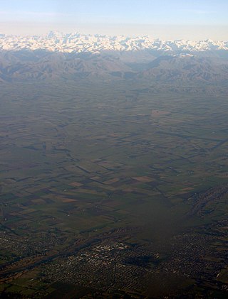
Mid Canterbury is a traditional, semi-official subregion of New Zealand's Canterbury Region extending inland from the Pacific coast to the Southern Alps. It is one of four traditional sub-regions of Canterbury, along with South Canterbury, North Canterbury, and Christchurch City.

Porters, is a commercial ski resort just over an hour's drive (98 km) west from Christchurch, in the South Island of New Zealand. Originally functioning as a club skifield, it has one beginner magic carpet, one platter tow, one chairlift and three t-bars. The difficulty of the slopes is distributed as 15% beginner, 35% intermediate and 50% advanced. Modern grooming equipment is used, and snowmaking facilities operate along the main pistes along the chairlift.
Valetta is a lightly populated locality in the mid-Canterbury region of New Zealand's South Island. It is located in an agricultural area on the southern side of the Ashburton River / Hakatere. Another river, the Hinds River, is to Valetta's southwest. Nearby settlements include Mount Somers to the northwest, Anama to the west, Mayfield to the southwest, and Punawai to the southeast. Its name is a misspelling of Valletta, the capital of Malta.

Broken River is a river in the South Island of New Zealand. It drains into the Waimakariri River due north of the town of Springfield.
The Goldney River is a river in the Canterbury region of New Zealand. It arises on the southern slopes of the Craigieburn Range and flows south into Lake Coleridge. The Goldney family were early squatters in the area.

The Harman River is a river of New Zealand. It starts in the Browning Range of the Southern Alps and becomes the Arahura River, which flows into the Tasman Sea north of Hokitika.
The Hawkins River is a river in New Zealand. A major tributary of Canterbury's Selwyn River, it flows generally southeast from its source to the southwest of Springfield, reaching the Selwyn 10 kilometres (6 mi) west of Burnham.
The Little Kowai River is a river of the Canterbury region of New Zealand's South Island. It flows generally south from the Torlesse Range to join with the Kowai River two kilometres north of Springfield.

The Mathias River is a river of the Canterbury region of New Zealand's South Island. It flows from its origins in three rivers in the Southern Alps. Of these, the North Mathias River is the longest, flowing predominantly southwards from its source northeast of Mount Williams. After 18 kilometres (11 mi) its waters combine with those of the West Mathias River, which flows predominantly southwest for 13 kilometres (8 mi) from its sources 10 kilometres (6 mi) west of Mount Williams. The South Mathias River, a tributary of the West Mathias River, is a 6-kilometre (4 mi) long easterly-flowing river which meets the West Mathias 5 kilometres (3 mi) from its confluence with the North Mathias.
The Porter River is a river of the Canterbury Region of New Zealand's South Island. It rises close to the southern end of the Craigieburn Range east of Lake Coleridge, flowing generally northeast to reach the Broken River close to Castle Hill. The Porters Ski Area is above the river valley's western flank, and State Highway 73 follows the river's course for some distance to the west of Porters Pass.
Canterbury's Esk River is a tributary of the Waimakariri River. It rises in the Dampier Range near Esk Head, and flows southwest on the western side of the Puketeraki Range to reach the upper Waimakariri some 20 kilometres (12 mi) north of Springfield.
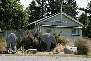
Alford Forest is a location in Ashburton District, Canterbury, New Zealand.

Lauriston is a lightly populated locality in the Canterbury region of New Zealand's South Island. It is situated on the Canterbury Plains south of the Rakaia River, some 20 kilometres (12 mi) inland from Rakaia. It was named after one of its pioneer settlers with the name of Laurie.

The Canterbury District Health Board was a district health board with the focus on providing healthcare to the Canterbury region of New Zealand, north of the Rangitata River. It was responsible for roughly 579,000 residents, or 12% of New Zealand's population. The Canterbury District Health Board covered a territory of 26,881 square kilometers and was divided between six territorial local authorities. In July 2022, the Canterbury DHB was merged into the national health service Te Whatu Ora.

Hakatere Conservation Park is a protected area between the Rakaia River and the Rangitata River in the Ashburton District of New Zealand. The park was established in 2007. It covers 60,000 hectares of rugged mountains and mountain basins, tussocklands and beech forest. It includes the Ashburton Lakes, such as Lake Heron and Lake Clearwater, popular tramping area Mount Somers / Te Kiekie, and Mount Hutt skifield. The closest town is Mount Somers.
