
Nelson Lakes National Park is in the South Island of New Zealand, at the northern end of the Southern Alps. It was created in 1956. The park contains beech forests, multiple lakes, snow-covered mountains and valleys created by glaciers during the ice ages.

Arthur's Pass National Park is located in the South Island of New Zealand and covers 1,185 km2 of mostly mountainous terrain. Adjacent to it lies Craigieburn Forest Park. The park is administered by the Department of Conservation.

The Heaphy Track is a popular tramping and mountain biking track in the north west of the South Island of New Zealand. It is located within the Kahurangi National Park and classified as one of New Zealand's ten Great Walks by the Department of Conservation. Named after Charles Heaphy, the track is 78.4 kilometres (48.7 mi) long and is usually walked in four or five days. The track is open for shared use with mountain bikers in the winter season from 1 May to 30 September each year. The southern end of the track is at Kōhaihai, north of Karamea on the northern West Coast, and the northern end is in the upper valley of the Aorere River, Golden Bay.
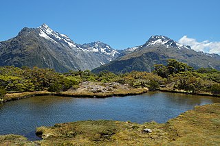
The Routeburn Track is a world-renowned, 32 km tramping (hiking) track found in the South Island of New Zealand. The track can be done in either direction, starting on the Queenstown side of the Southern Alps, at the northern end of Lake Wakatipu or on the Te Anau side, at the Divide, several kilometres from the Homer Tunnel to Milford Sound.

The Dobson River is a river in the South Island of New Zealand. It flows south between the Neumann and Ohau ranges for 45 kilometres (28 mi) from its source to the east of Mount Hopkins, in the Southern Alps, before joining with the Hopkins River, close to the latter's entry into the northern end of Lake Ōhau in the Mackenzie Country. The river flows over wide shingle beds, and has no rapids of interest to whitewater enthusiasts. It was named by Julius von Haast in the 1860s for his father-in-law, Edward Dobson, who was the Canterbury Provincial Engineer. The Māori name, also given as Otao in some works, means "driftwood," and has also been applied to the Hopkins River into which the Dobson/Ōtaao flows.
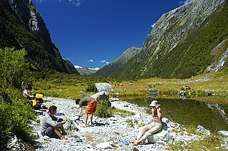
The Milford Track is a hiking route in New Zealand, located amidst mountains and temperate rain forest in Fiordland National Park in the southwest of the South Island. The 53.5 km (33.2 mi) hike starts at Glade Wharf at the head of Lake Te Anau and finishes in Milford Sound at Sandfly Point, traversing rainforests, wetlands, and an alpine pass.

The Kepler Track is a 60 km (37 mi) circular hiking track which travels through the landscape of the South Island of New Zealand and is situated near the town of Te Anau. The track passes through many landscapes of the Fiordland National Park such as rocky mountain ridges, tall mossy forests, lake shores, deep gorges, rare wetlands and rivers. Like the mountains it traverses, the track is named after Johannes Kepler. The track is one of the New Zealand Great Walks and is administered by the Department of Conservation (DOC).
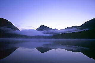
Lake Daniell is a lake in the West Coast Region of the South Island of New Zealand. Until 2008 the lake was officially named as Lake Daniells.

Lake Sumner Forest Park is a 1,051 km2 (406 sq mi) forest park located in the Canterbury region of the South Island of New Zealand. It is centered around Lewis Pass and has a number of access points along State Highway 7. It sits in between Lewis Pass Scenic Reserve and Arthurs Pass National Park.
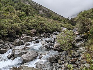
The Deception River is a river in New Zealand. It is a tributary of the West Coast's Ōtira River, flowing generally north for 17 kilometres (11 mi) from its source on the slopes of Mount Franklin. It passes close to Goat Pass, which gives access to the Mingha River. Almost the entire length of the river is within the Arthur's Pass National Park.

The Doubtful River is a river in the Canterbury region of New Zealand. It rises near Mount Barron and flows south then south-east through Lake Sumner Forest Park, reaching the Boyle River 40 kilometres (25 mi) west of Hanmer Springs. The Doubtful Range lies to the south. The Doubtless River and Devilskin Stream are tributaries entering from the north.

The Edwards River is a river of New Zealand. A tributary of the Bealey River, it arises in the Polar Range to the east of Arthur's Pass and flows south-west within Arthur's Pass National Park. The Mingha River joins it just before it enters the Bealey. It is one of the headwaters of the Waimakariri River.
The Grebe River is a river in Fiordland, New Zealand. It arises north-west of Lake Monowai in an area once part of the lake but cut off by an enormous landslide about 13,000 years ago. The river now flows north, between the Townley Mountains to the west, and the Hunter Mountains to the east, and into Lake Manapouri's South Arm. Its major tributaries are Jaquiery Stream, Florence Stream, Emerald Stream, and Percy Stream, all from the west.

The Fox River is a river in the Buller District of New Zealand. It arises in the Paparoa Range near Mount Dewar and flows north-west through the Paparoa National Park to the Tasman Sea at Woodpecker Bay. The river passes through a spectacular gorge. The northern branch of the river has limestone caves containing stalactite and stalagmite formations.
The Crow River is a river located in Kahurangi National Park in the West Coast Region of New Zealand. It arises in the Wharepapa / Arthur Range and flows south-west and then north-west into the Karamea River. The river may be named after the South Island kōkako, sometimes called the orange-wattled crow.
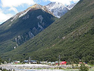
Arthur's Pass, previously called Camping Flat then Bealey Flats, and for some time officially Arthurs Pass, is a township in the Southern Alps of the South Island of New Zealand, located in the Selwyn district. It is a popular base for exploring Arthur's Pass National Park.

The Copland Pass is an alpine pass in the Southern Alps of New Zealand. Known as Noti Hinetamatea by the indigenous Ngāi Tahu, the pass follows the route of the Makaawhio ancestor Hinetamatea and her sons Tātāwhākā and Marupeka.
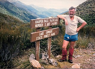
Harper Pass, previously known as Hurunui Pass or sometimes Taramakau Pass, is an alpine pass between Canterbury and the West Coast in New Zealand. It was the most important crossing for Māori to obtain pounamu. The first European crossed the pass in 1857 and the leader of the second party later that year, Leonard Harper, gave the pass its current name. It was of some interest to the settlers as the West Coast was part of Canterbury Province and it remained the only feasible route for some years. When the West Coast Gold Rush started in 1864, it became a heavily used crossing and remained so until October 1865, when a dray road over Arthur's Pass opened. The Arthur's Pass route was upgraded in March 1866 to coach traffic standard, and the much less direct route over Harper Pass fell out of use. It was restored in the 1930s as a tramping route and the Harper Pass Track, a four or five-day tramp, is today part of Te Araroa over its entire length.

The Copland Track is a tramping track in the south Westland area of New Zealand's South Island, well known for the naturally-occurring hot springs at Welcome Flat along its route. The main track is approximately 25 kilometres (16 mi) long one-way from the trailhead at State Highway 6 to the track's inland end at the Douglas Rock Hut, and is usually completed in 2 to 4 days depending on whether the full distance is walked, with many opting to walk only as far as Welcome Flat. The track is the western portion of a longer path which historically connected the West Coast to Mount Cook Village via Copland Pass, however erosion and the retreat of the Hooker Glacier has led to the eastern side of this route becoming increasingly dangerous to traverse.

The historic Haast to Paringa Cattle Track is a trail through South Westland, New Zealand, constructed in 1875 to allow farmers in the Landsborough and Cascade Valley area to drive their cattle on an annual two-week journey to the sale yards in Whataroa. It was constructed as an inland loop to bypass the precipitous cliffs at Knights Point. For 90 years it was the only land access to the settlements of Haast and Jackson Bay, but the last mob of cattle was driven in 1961, and the construction of a highway connecting Paringa to Haast Pass in 1965 made it redundant. After falling into disuse, the cattle track was converted into a 33-kilometre (21 mi), three-day tramping track, opening in 1981. The track and its three huts are maintained by the New Zealand Department of Conservation.


