
Arthur's Pass National Park is located in the South Island of New Zealand and covers 1,185 km2 of mostly mountainous terrain. Adjacent to it lies Craigieburn Forest Park. The park is administered by the Department of Conservation.

Kaiapoi is a town in the Waimakariri District of the Canterbury region, in the South Island of New Zealand. The town is located approximately 17 kilometres north of central Christchurch, close to the mouth of the Waimakariri River. It is considered a satellite town of Christchurch and is part of the Christchurch functional urban area. The town is named after the nearby Kaiapoi Pā.

The Waimakariri River is one of the largest rivers in Canterbury, on the eastern coast of New Zealand's South Island. It flows for 151 kilometres (94 mi) in a generally southeastward direction from the Southern Alps across the Canterbury Plains to the Pacific Ocean.
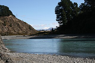
The Waimakariri Gorge is located on the Waimakariri River in inland Canterbury in the South Island of New Zealand.

Waimakariri District is a local government district, located in the Canterbury Region of New Zealand's South Island. It is named after the Waimakariri River, which forms the district's southern boundary, separating it from Christchurch City and the Selwyn District. It is bounded in the north by the Hurunui District and in the east by the Pacific Ocean.

The Oxford Branch was a branch line railway that formed part of New Zealand's national rail network. It was located in the Canterbury region of the South Island, and ran roughly parallel with the Eyreton Branch that was located some ten kilometres south. It opened to Oxford in 1875 and survived until 1959.

The Harper River is a tributary of the Wilberforce River which itself flows into the Rakaia River in New Zealand's Canterbury region. It is located in the Southern Alps and a pass in the Harper River headwaters leads into the Waimakariri River catchment. One of the most popular tramping routes in Canterbury enters the East Harper via Cass Saddle and exits via Lagoon Saddle at the head of the West Harper.
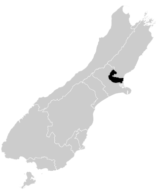
Waimakariri is a New Zealand parliamentary electorate, formed for the 1996 election and returning one Member of Parliament to the New Zealand House of Representatives. The MP for Waimakariri is Matt Doocey of the National Party. He has held this position since the 2014 election and takes over from Kate Wilkinson, who defeated Clayton Cosgrove (Labour) in the 2011 election.
The Crow River is a river in Arthur's Pass National Park, Canterbury, New Zealand. It arises near Mount Rolleston and flows south into the Waimakariri River.

The Edwards River is a river of New Zealand. A tributary of the Bealey River, it arises in the Polar Range to the east of Arthur's Pass and flows south-west within Arthur's Pass National Park. The Mingha River joins it just before it enters the Bealey. It is one of the headwaters of the Waimakariri River.
The Eyre River is a river in the Canterbury region of New Zealand. It arises in the Puketeraki Range and flows south-east into the Waimakariri River near Christchurch International Airport. The connection with the Waimakariri is via a diversion channel running south-west, replacing the Eyre's original easterly flow. The river is named after Edward John Eyre, the Lieutenant-Governor of New Munster from 1848 to 1853.

Matthew Maurice Doocey is a New Zealand politician who was elected to the New Zealand Parliament at the 2014 general election as a representative of the New Zealand National Party. He was re-elected in 2017 with a majority increase of over 10,000 which was a significant increase from a majority of 2,500 in 2014. It was reported that this was the largest personal vote increase in the country.

Courtenay is a settlement in inland Canterbury, New Zealand. It was once important as a place where the Waimakariri River could be forded and was a coach stop on the way to the West Coast. Its decline began when the Midland Line was routed via the nearby Kirwee.

Daniel Peter Rosewarne is a New Zealand politician and former military officer. He was a Member of Parliament in the New Zealand House of Representatives for the New Zealand Labour Party from July 2022 until October 2023.

Trevor James Hill Chinn was a New Zealand glaciologist, who conducted extensive surveys of the glaciers of New Zealand's Southern Alps.

Kainga is a settlement on the southern bank of the Waimakariri River, just north of Christchurch, in Canterbury, New Zealand. It lies immediately to the south of Kaiapoi, on a small road leading northeast from State Highway 1.
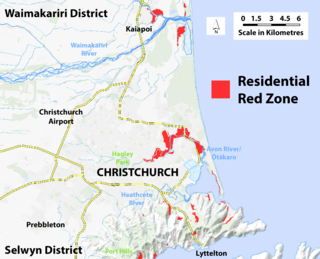
A residential red zone is any of several areas of land in and around Christchurch, New Zealand, that experienced severe damage in the 2010 and 2011 Christchurch earthquakes and were deemed infeasible to rebuild on. Through voluntary buyouts, the Crown acquired and demolished or removed over 8,000 properties. The majority were located in a broad swath of the eastern suburbs along the Avon River / Ōtākaro that had suffered damage from soil liquefaction.
McLeans Island is a rural area north and northwest of Christchurch city, and south of Waimakariri River.

Waimakariri River Regional Park is a regional park in the Canterbury Region of New Zealand's South Island. It covers 15,000 hectares on the banks of the Waimakariri River, and is operated by Environment Canterbury.

Northern Pegasus Bay is a regional park in the northern part of Canterbury's Pegasus Bay in New Zealand's South Island. It is operated by Environment Canterbury.
This page is based on this
Wikipedia article Text is available under the
CC BY-SA 4.0 license; additional terms may apply.
Images, videos and audio are available under their respective licenses.


