
Arthur's Pass National Park is located in the South Island of New Zealand and covers 1,185 km2 of mostly mountainous terrain. Adjacent to it lies Craigieburn Forest Park. The park is administered by the Department of Conservation.

Arthur's Pass is a mountain pass in the Southern Alps of the South Island of New Zealand. The pass sits 920 metres or 3,020 feet above sea level and marks part of the boundary between the West Coast and Canterbury regions. Located 140 km from Christchurch and 95 km from Greymouth, the pass comprises part of a saddle between the valleys of the Ōtira River and of the Bealey River. Arthur's Pass lies on the border of the Selwyn and Westland districts.

The Waimakariri River is one of the largest rivers in Canterbury, on the eastern coast of New Zealand's South Island. It flows for 151 kilometres (94 mi) in a generally southeastward direction from the Southern Alps across the Canterbury Plains to the Pacific Ocean.

Otehake River is located on the West Coast of the South Island of New Zealand. It flows northward through the Arthur's Pass National Park and into the Taramakau River.

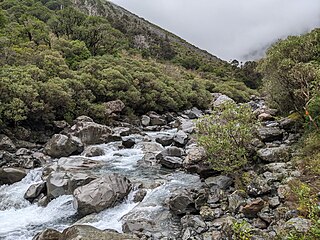
The Bealey River is a small river located in the Southern Alps of New Zealand. It is a tributary of the Waimakariri River. Its valley forms the eastern approach to Arthur's Pass. The river and the Bealey settlement are named for Samuel Bealey, a 19th-century Superintendent of Canterbury Province and pastoralist.
Edwards River may refer to:

The N class were 12 steam locomotives that operated on the national rail network of New Zealand. They were built in three batches, including one batch of two engines for the private Wellington and Manawatu Railway Company, the WMR, by the Baldwin Locomotive Works in 1885, 1891, and 1901. Previously the N class designation had been applied between 1877 and 1879 to Lady Mordaunt, a member of the B class of 1874.
The Wellington and Manawatu Railway Trust is a charitable trust based in Wellington, New Zealand, and is actively restoring former Wellington and Manawatu Railway locomotive No.9, to full working order.

Cass is a small locality in inland Canterbury on New Zealand's South Island, near Arthur's Pass. It is known for its small railway station which was the subject of the 1936 painting Cass by Rita Angus, voted in 2006 New Zealand's favourite work of art. It is also the location of a University of Canterbury field station established in 1914. Cass currently has a single permanent resident.
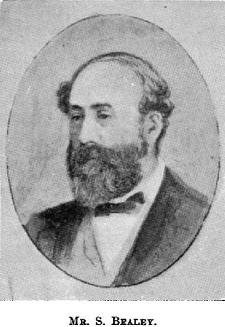
Samuel Bealey was a 19th-century politician in Canterbury, New Zealand.

The New Zealand V class steam locomotive was used on New Zealand's railway network from 1885 onwards. They were operated by New Zealand Government Railways and the Wellington and Manawatu Railway Company.
The 1929 Arthur's Pass earthquake occurred at on 9 March. The sparsely settled region around Arthur's Pass of the Southern Alps shook for four minutes. Tremors continued almost continuously until midnight and sporadic strong aftershocks were felt for several days.
The Crow River is a river in Arthur's Pass National Park, Canterbury, New Zealand. It arises near Mount Rolleston and flows south into the Waimakariri River.
The Deception River is a river in New Zealand. It is a tributary of the West Coast's Ōtira River, flowing generally north for 17 kilometres (11 mi) from its source on the slopes of Mount Franklin. It passes close to Goat Pass, which gives access to the Mingha River. Almost the entire length of the river is within the Arthur's Pass National Park.

The Mingha River is a river of the Canterbury Region of New Zealand's South Island. It flows east then south from its origin on the slopes of Mt Temple, meeting the Bealey River 8 kilometres (5 mi) south of Arthur's Pass.
Cox River is a river of the Canterbury region of New Zealand. It arises in the Crawford Range of the Southern Alps and flows generally southward through the Arthur's Pass National Park to join the Poulter River. The river was named for J. W. M. Cox, a landholder in the 1860s at the junction of Cox River and Bull Creek.
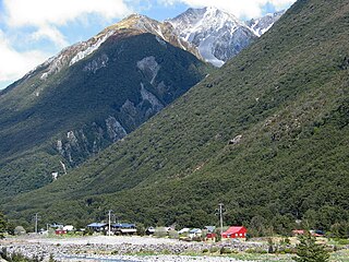
Arthur's Pass, previously called Camping Flat then Bealey Flats, and for some time officially Arthurs Pass, is a township in the Southern Alps of the South Island of New Zealand, located in the Selwyn district. It is a popular base for exploring Arthur's Pass National Park.

State Highway 73 is a major east-west South Island state highway in New Zealand connecting Christchurch on the east coast with Cass/Hokitika via the Southern Alps. It is mostly two lane, with some single-lane bridges north of Springfield but is mostly dual carriageway in Christchurch. The fourth and fifth-highest points of New Zealand's state highway network are on this road at Porters Pass and Arthur's Pass respectively.

Omoto locomotive dump is a New Zealand Railways locomotive and rolling stock dump site located near Greymouth, New Zealand. The dump site is located on the southern bank of the Grey River, close to the Midland Line and State Highway 6.

The Four Avenues are a group of four major arterial boulevards — Bealey Avenue, Fitzgerald Avenue, Moorhouse Avenue, and either Rolleston Ave or Deans Avenue — that surround the city centre of Christchurch, New Zealand. Serving as an inner ring road, they popularly form the limits of the city centre, separating it from the city's suburbs. Almost all of the city's commercial heart lies within the approximately rectangular 9.8-square-kilometre (3.8 sq mi) area formed by the four avenues. The term "within the Four Avenues" is widely used in Christchurch to refer to the central city. By extension, Christchurch as a whole is sometimes referred to as "The Four Avenues".


