
Arthur's Pass National Park is located in the South Island of New Zealand and covers 1,185 km2 of mostly mountainous terrain. Adjacent to it lies Craigieburn Forest Park. The park is administered by the Department of Conservation.

Kaiapoi is a town in the Waimakariri District of the Canterbury region, in the South Island of New Zealand. The town is located approximately 17 kilometres north of central Christchurch, close to the mouth of the Waimakariri River. It is considered a satellite town of Christchurch and is part of the Christchurch functional urban area. The town is named after the nearby Kaiapoi Pā.

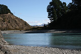
The Waimakariri River is one of the largest rivers in Canterbury, on the eastern coast of New Zealand's South Island. It flows for 151 kilometres (94 mi) in a generally southeastward direction from the Southern Alps across the Canterbury Plains to the Pacific Ocean.

The Kaiapoi River is a minor river of north Canterbury, in New Zealand's South Island. Originally called the Cam River, it is a tributary of the Waimakariri River, which it joins at the larger river's estuary. The river is 16 kilometres (10 mi) long, and its drainage area is about 430 square kilometres (170 sq mi).

Craigieburn is the name of a settlement and several geographic features in northwest Canterbury, in New Zealand's South Island.
The Waimakariri Gorge is located on the Waimakariri River in inland Canterbury in the South Island of New Zealand.

Waimakariri District is a local government district, located in the Canterbury Region of New Zealand's South Island. It is named after the Waimakariri River, which forms the district's southern boundary, separating it from Christchurch City and the Selwyn District. It is bounded in the north by the Hurunui District and in the east by the Pacific Ocean.

Catherine Joan Wilkinson is a New Zealand farmer and politician. She was a member of the New Zealand House of Representatives for the National Party from 2005 until her retirement in 2014. From 2008 until January 2013, she was a member of cabinet, holding the portfolios of Labour, Conservation, Food Safety, and Associate Immigration, before being removed from cabinet by Prime Minister John Key.

The Oxford Branch was a branch line railway that formed part of New Zealand's national rail network. It was located in the Canterbury region of the South Island, and ran roughly parallel with the Eyreton Branch that was located some ten kilometres south. It opened to Oxford in 1875 and survived until 1959.
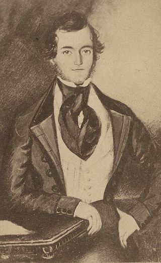
Joseph Hawdon was a pioneer settler and overlander of Australia, and pioneer and politician of New Zealand.

The Cust River is a river in the Canterbury region of New Zealand. It flows east across the upper Canterbury Plains from its source north of the town of Oxford, New Zealand, flowing into the Cam River / Ruataniwha close to the town of Rangiora. The small town of Cust lies on the banks of the river. The lower part of the river, to the south-west of Rangiora, is diverted into a channel and called the "Main Drain". The channel was built in 1862 to drain the swampy land between Rangiora and the Waimakariri River, and when it was enlarged in 1868 it accidentally captured the Cust.
The Eyre River is a river in the Canterbury region of New Zealand. It arises in the Puketeraki Range and flows south-east into the Waimakariri River near Christchurch International Airport. The connection with the Waimakariri is via a diversion channel running south-west, replacing the Eyre's original easterly flow. The river is named after Edward John Eyre, the Lieutenant-Governor of New Munster from 1848 to 1853.
Canterbury's Esk River is a tributary of the Waimakariri River. It rises in the Dampier Range near Esk Head, and flows southwest on the western side of the Puketeraki Range to reach the upper Waimakariri some 20 kilometres (12 mi) north of Springfield.
Flock Hill station is located in New Zealand's South Island high country, in the Waimakariri River basin, 75 minutes drive from Christchurch on State Highway 73 which is now commonly known as The Great Alpine Highway between Castle Hill Station and Cass near Lake Pearson.

Courtenay is a settlement in inland Canterbury, New Zealand. It was once important as a place where the Waimakariri River could be forded and was a coach stop on the way to the West Coast. Its decline began when the Midland Line was routed via the nearby Kirwee.
Lake Hawdon is a small high country lake in Canterbury, New Zealand.
Hawdon is a surname originating in the north of England and may refer to:
McLeans Island is a rural area north and northwest of Christchurch city, and south of Waimakariri River.

Waimakariri River Regional Park is a regional park in the Canterbury Region of New Zealand's South Island. It covers 15,000 hectares on the banks of the Waimakariri River, and is operated by Environment Canterbury.

Northern Pegasus Bay is a regional park in the northern part of Canterbury's Pegasus Bay in New Zealand's South Island. It is operated by Environment Canterbury.


