Oxford Branch (New Zealand)

Last updated

Oxford Branch
Springbank engine shed, Oxford Branch.jpg
Springbank engine shed and its station sign, December 2023
Overview
StatusClosed
Owner Railways Department
Locale Canterbury, New Zealand
Termini
Stations13
Service
Type Heavy Rail
System New Zealand Government Railways (NZGR)
Operator(s) Railways Department
History
Opened28 July 1884 (1884-07-28)
Closed14 July 1930 (1930-07-14) (Sheffield – Oxford East)
19 April 1959 (1959-04-19) (Oxford East – Rangiora)
Technical
Line length35.47 km (Rangiora – Oxford West)
Number of tracksSingle
CharacterRural
Track gauge 3 ft 6 in (1,067 mm)
Route map

Contents

km
BSicon CONTgq.svg
BSicon eABZq+l.svg
BSicon lBHF.svg
BSicon CONTf@Fq.svg
0.00
Rangiora
BSicon exHST.svg
Bells
BSicon exHST.svg
Fernside
BSicon exHST.svg
Stoke
BSicon exHST.svg
Springbank
(Moeraki)
BSicon exHST.svg
Cust
BSicon exABZg+l.svg
BSicon exCONTfq.svg
BSicon exHST.svg
32.41
Bennetts Junction
BSicon exHST.svg
Carleton
BSicon exBHF.svg
Oxford East
BSicon exHST.svg
35.47
Oxford West
BSicon exHST.svg
View Hill
BSicon exHST.svg
Bexley
BSicon exhbKRZWae.svg
Waimakariri River Gorge
BSicon CONTg@Gq.svg
BSicon exlHST.svg
BSicon eABZqr.svg
BSicon CONTfq.svg
Sheffield
(Malvern)
Oxford Branch (New Zealand)
Map

The Oxford Branch was a branch line railway that formed part of New Zealand's national rail network. It was located in the Canterbury region of the South Island, and ran roughly parallel with the Eyreton Branch that was located some ten kilometres south. It opened to Oxford in 1875 and survived until 1959. [1]

It was unusual in that for much of its life it linked two main lines, the Main North Line and the Midland Line, the only portion of the proposed Canterbury Interior Main Line to be completed.

Construction

In the late 1860s, the Oxford region had poor transport, and as it had one of Canterbury's two major stands of timber (the Little River Branch was built to the other) it was seen as economically important to build a branch line to transport the timber. The Main North Line up the east coast from Christchurch was under construction and a number of proposals were made of routes from the mainline to Oxford. Two proposals were accepted, from Rangiora to Oxford and from Kaiapoi to West Eyreton (the Eyreton Branch).

Construction was undertaken by central government even though the Canterbury Provincial Railways were building the Main North Line, and work began in mid-1872, four months before the mainline reached Rangiora. The mainline was being built to 1,600 mm (5 ft 3 in) while the branch was the newly nationally accepted 1,067 mm (3 ft 6 in) narrow gauge, and this created a break of gauge in Rangiora for a brief period until the Canterbury Provincial Railways were converted to narrow gauge. [2]

On 1 December 1874, the branch was opened from Rangiora to Cust, and to Oxford on 21 June 1875 with two stations in Oxford, East and West: East Oxford was considered to be the main station. In early 1877, the Public Works Department decided to extend the Eyreton Branch to the Oxford Branch at Bennetts Junction, opened on 1 February 1878. An extension of the Oxford Branch soon followed, despite the Long Depression of the 1880s and the disapproval of a Royal Commission in 1880, to Sheffield, then known as Malvern and the terminus of a branch line that became the Midland Line. This opened on 28 July 1884 with its most notable engineering feat being a combined road/rail bridge over the Waimakariri Gorge. At this stage, the branch from Kaiapoi to Sheffield was seen as the most northerly portion of the proposed Canterbury Interior Main Line, but it was the only portion to be built.

Operation

From its opening, the branch saw two mixed trains each way per day and a locomotive depot was established in Oxford. Once the connection with the Eyreton Branch was established, one daily train ran to Oxford from that line too. The trip from Christchurch to Oxford took three hours, including an hour and 40 minutes from Rangiora to the terminus. The extension from Oxford to Sheffield saw only light local traffic, and its sole moment of significant worth came during World War I. The war stimulated enough traffic to justify two trains daily, but with the coming of peace trains fell to a single weekly service. Had the Midland Line and Main North Line both been completed earlier, the route could have become a convenient shortcut and bypass of Christchurch from the West Coast to northern east coast destinations, but it mainly carried picnic trains and small quantities of local goods. Only one locomotive at a time was allowed on the bridge over the Waimakariri River despite its good condition, though it is doubtful this policy ever had to be enforced. Lacklustre traffic meant that the line was cut back to Oxford on 14 July 1930, reducing the branch's length to 35.5 kilometres.

Also in 1930, a Royal Commission determined that only one freight train daily from Christchurch to Oxford was required, and the New Zealand Railways Department acted upon this recommendations. West Oxford's locomotive depot was closed, and on 9 February 1931 the branch became goods only and the link from the Eyreton Branch was closed. Services remained daily until 1945, when they were cut to twice weekly. With financial losses increasing and traffic decreasing, the branch closed on 19 April 1959.

Today

The embankment and an abutment of a bridge on the final section of track bed coming into Sheffield. Oxford Branch Dec 2023 (1).jpg
The embankment and an abutment of a bridge on the final section of track bed coming into Sheffield.

The bridge over the Waimakariri River still carries the road, performing half of its original function as a road/rail bridge. The road from Oxford approaches the bridge along the railway alignment as it took a much easier route than the original road; the old winding road route is visible from the current road. The railway's track bed is sometimes still visible, especially around the Waimakariri Gorge area, and in Rangiora the extra width of Blackett Street reveals the route. Loading banks still exist at the sites of Bennetts Junction and Carleton stations; Fernside and Springbank both still have their goods sheds, loading banks, and stockyards; replica station signs can be found at a few sites of old stations; and until 1997 East Oxford station stood behind the Oxford Working Men's Club. It was relatively large for a rural New Zealand station and was once well preserved, but it fell into such a severe state of disrepair that it was demolished and all that remains are the almost indestructible station safe and the platform.

Related Research Articles

<span class="mw-page-title-main">Kaiapoi</span> Town in Canterbury, New Zealand

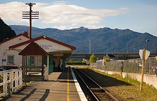
Kaiapoi is a town in the Waimakariri District of the Canterbury region, in the South Island of New Zealand. The town is located approximately 17 kilometres north of central Christchurch, close to the mouth of the Waimakariri River. It is considered a satellite town of Christchurch and is part of the Christchurch functional urban area. The town is named after the nearby Kaiapoi Pā.

<span class="mw-page-title-main">Rangiora</span> Town in Canterbury, New Zealand

Rangiora is the largest town and seat of the Waimakariri District, in Canterbury, New Zealand. It is 29 kilometres (18 mi) north of Christchurch, and is part of the Christchurch metropolitan area. With an estimated population of 19,600, Rangiora is the 30th largest urban area in New Zealand, and the fifth-largest in the Canterbury region.

<span class="mw-page-title-main">Oxford, New Zealand</span> Town in Canterbury, New Zealand

Oxford is a small town serving the farming community of North Canterbury, New Zealand. It is part of the Waimakariri District and is a linear town, approximately 2 kilometres (1.2 mi) long. Oxford has won awards for the most beautiful village and the most beautiful toilet.

<span class="mw-page-title-main">South Island Main Trunk Railway</span> Railway in New Zealand

The Main North Line between Picton and Christchurch and the Main South Line between Lyttelton and Invercargill, running down the east coast of the South Island of New Zealand, are sometimes together referred to collectively as the South Island Main Trunk Railway (SIMT). Construction of a line running the length of the east coast began in the 1860s and was completed all the way from Picton to Invercargill in 1945; the last sections being on the Main North Line south of Picton. The designation "South Island Main Trunk" originally referred to only that line between Christchurch and Invercargill.

<span class="mw-page-title-main">Main South Line</span> Railway line in New Zealand

The Main South Line, sometimes referred to as part of the South Island Main Trunk Railway, is a railway line that runs north and south from Lyttelton in New Zealand through Christchurch and along the east coast of the South Island to Invercargill via Dunedin. It is one of the most important railway lines in New Zealand and was one of the first to be built, with construction commencing in the 1860s. At Christchurch, it connects with the Main North Line to Picton, the other part of the South Island Main Trunk.

The Methven Branch was a branch line railway that was part of New Zealand's national rail network in Canterbury. It opened in 1880 and operated until 1976.

<span class="mw-page-title-main">Midland Line, New Zealand</span>

The Midland line is a 212 km section of railway between Rolleston and Greymouth in the South Island of New Zealand. The line features five major bridges, five viaducts and 17 tunnels, the longest of which is the Otira tunnel. It is the route of the popular TranzAlpine passenger train.

The Eyreton Branch was a branch line railway that formed part of New Zealand's national rail network. Located in the Canterbury region of the South Island, it left the Main North Line in Kaiapoi and was built a mere ten kilometres south of the Oxford Branch. It opened in 1875 and operated until 1954, except for the first portion, which remained open until 1965.

The Canterbury Interior Main Line was a proposed railway line that would have linked many of the branch lines in the Canterbury region of New Zealand's South Island. Although it was never built in full, its most northerly portion was constructed.

The Southbridge Branch was a branch line railway that formed part of New Zealand's national rail network. It was located in the Canterbury region of the South Island and operated from 1875 until 1967. Five kilometres of the line remains open as the Hornby Branch, formerly the Hornby Industrial Line.

<span class="mw-page-title-main">Whitecliffs Branch</span> NZ South Island old rail line

The Whitecliffs Branch was an 18.4 kilometres (11.4 mi) long branch line railway that formed part of New Zealand's national rail network in the Canterbury region of the South Island. It was more industrial than the many rural branches on the South Island's east coast whose traffic primarily derived from agriculture, and it operated from 1875 until 1962.

The Waiau Branch was a branch line railway in the northern Canterbury region of New Zealand's South Island. Known as the Great Northern Railway for its first few decades of life, the Waiau Branch was seen as part of a main line north but was ultimately superseded by a coastal route. Opened in stages from 1882 to 1919, the line closed in 1978 but a portion has been retained as the Weka Pass Railway.

<span class="mw-page-title-main">Main North Line, New Zealand</span> Railway line in New Zealand between Picton and Christchurch

The Main North Line, sometimes referred to as part of the South Island Main Trunk railway, is a railway line that runs north from Christchurch in New Zealand up the east coast of the South Island through Kaikōura and Blenheim to Picton. It is a major link in New Zealand's national rail network and offers a connection with roll-on roll-off ferries from Picton to Wellington. It was also the longest railway construction project in New Zealand's history, with the first stages built in the 1870s and not completed until 1945.

<span class="mw-page-title-main">Ross Branch (railway line)</span>

The Ross Branch, officially known as the Hokitika Line since 2011, and previously as the Hokitika Industrial Line, is a branch line railway that forms part of New Zealand's national rail network. It is located in the Westland District of the South Island's West Coast region and opened to Hokitika in 1893. A further extension to Ross operated from 1909 until 1980.

Rail transport in Christchurch, the largest city on New Zealand's South Island, consists of two main trunk railway lines intersecting in the suburb of Addington, carrying mainly long-haul freight traffic but also two long distance tourist-oriented passenger trains. The two lines are the Main North Line and Main South Line, collectively but unofficially known as the South Island Main Trunk Railway. There is a heritage line at the Ferrymead Historic Park that is operated with steam, electric, and diesel motive power hauling tourist-oriented services.

<span class="mw-page-title-main">Swannanoa, New Zealand</span> Settlement in Canterbury, New Zealand

Swannanoa is a small village in Canterbury, New Zealand. It is located 35 kilometres northwest of the largest city in the South Island, Christchurch. The area has an estimated population of 1,040 with 280 pupils enrolled in the primary school. The population is slowly increasing due to new subdivisions being developed there and in neighbouring Mandeville North.

<span class="mw-page-title-main">Lyttelton Line</span> Railway line between Lyttelton and Christchurch, New Zealand

Lyttelton Line is a name sometimes used to refer to the section of the Main South Line in New Zealand's South Island between Lyttelton and Christchurch, and can also be used to refer to the operations on this section. As it has always been part of the Main South Line, this name has never been officially used to refer to the track itself.

<span class="mw-page-title-main">Papanui railway station</span> Defunct railway station in New Zealand

Papanui railway station served the suburb of Papanui in northern Christchurch, New Zealand. It was on the Main North Line between the stations of Bryndwr and Styx, 5.3 kilometres (3.3 mi) north of Addington Junction. The station handled freight and passenger traffic from when it opened in 1872 until closing in the late 20th century, and from 1880 was the site of an interchange between passenger rail and trams until the 1930s.

<span class="mw-page-title-main">Ashley Rakahuri Regional Park</span> Regional park

Ashley Rakahuri Regional Park is a regional park in the Canterbury Region of New Zealand's South Island. It covers 417 hectares on the banks of Ashley River / Rakahuri and Okuku River, and is operated by Environment Canterbury. The park is used for fishing, walking, swimming, cycling and family picnics.

References

Citations

  1. "History of the Oxford-Rangiora-Sheffield railway line". Waimakariri Libraries.
  2. Agnew 2017, p. 65.

Bibliography

  • Agnew, John (December 2017). "Canterbury Railways". New Zealand Railfan. 24 (1): 64-75. ISSN   1173-2229.
  • Churchman, Geoffrey B; Hurst, Tony (2001) [1990, 1991]. The Railways of New Zealand: A Journey through History (Second ed.). Transpress New Zealand. ISBN   0-908876-20-3.
  • Leitch, David; Scott, Brian (1995). Exploring New Zealand's Ghost Railways (1998 ed.). Wellington: Grantham House. ISBN   1-86934-048-5.
  • Hermann, Bruce J; South Island Branch Lines pp 6,7 (1997, New Zealand Railway & Locomotive Society, Wellington) ISBN   0-908573-70-7
  • Mulligan, Barbara (2000). New Zealand Rail Trails: A Guide to 42 Ghost Lines. Wellington: Grantham House Publishing. pp. 109–114. ISBN   978-1-86934-126-8.

Commons-logo.svg Media related to Oxford Branch (New Zealand) at Wikimedia Commons