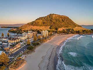
Mount Maunganui is a major residential, commercial and industrial suburb of the Tauranga metropolitan area, located on a peninsula to the north-east of Tauranga's city centre. It was an independent town from Tauranga until the completion of the Tauranga Harbour Bridge in 1988, which connects Mount Maunganui to Tauranga's central business district.
The Taonui Branch was a minor branch line railway in New Zealand's national network. Located in the Manawatū District of the North Island, it opened in 1879 and operated until 1895.

The Foxton Branch was a railway line in New Zealand. It began life as a tramway, reopened as a railway on 27 April 1876, and operated until 18 July 1959. At Himatangi there was a junction with the Sanson Tramway, a line operated by the Manawatu County Council that was never upgraded to the status of a railway.

Mercury Baypark Stadium is a multi-purpose stadium in Mount Maunganui, New Zealand. It is currently used for dirt track Speedway and jetsprints events during summer, and various other events throughout the year.
The Taneatua Express was an express passenger train operated by the New Zealand Railways Department that ran between Auckland and Taneatua in the Bay of Plenty, serving centres such as Tauranga and Te Puke. It commenced in 1929 and operated until 1959.

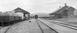
The East Coast Main Trunk (ECMT) is a railway line in the North Island of New Zealand, originally running between Hamilton and Taneatua via Tauranga, connecting the Waikato with the Bay of Plenty. The ECMT now runs between Hamilton and Kawerau, with a branch line to Taneatua from the junction at Hawkens. The line is built to narrow gauge of 1,067 mm, the uniform gauge in New Zealand. It was known as the East Coast Main Trunk Railway until 2011, when the word "Railway" was dropped.

The Goldfields Railway is a heritage railway that operates between Waihi and Waikino in the Bay of Plenty region of New Zealand's North Island. It operates over a section of track that was part of the East Coast Main Trunk Railway until the Kaimai Tunnel deviation made it redundant in 1978. The Goldfields Railway was formed in 1980 as the Goldfields Steam Train Society to retain a portion of the old mainline and switched to its current name in the mid-nineties.
There have been a number of proposals to build a Taupō Line as a branch railway linking the township of Taupō in the central North Island of New Zealand to New Zealand's rail network. One proposal proceeded as far as the construction stage before being stopped.
The Palmerston North–Gisborne Line (PNGL) is a secondary main line railway in the North Island of New Zealand. It branches from the North Island Main Trunk at Palmerston North and runs east through the Manawatū Gorge to Woodville, where it meets the Wairarapa Line, and then proceeds to Hastings and Napier in Hawke's Bay before following the coast north to Gisborne. Construction began in 1872, but the entire line was not completed until 1942. The line crosses the runway of Gisborne Airport, one of the world's only railways to do so since Pakistan's Khyber Pass Railway closed.
The Rotorua Branch is a railway line from Putāruru to Rotorua, in the Waikato and Bay of Plenty regions of the North Island of New Zealand. Construction of the line was commenced by the Thames Valley and Rotorua Railway Company and finished by the Public Works Department (PWD). The complete line, 50.5 kilometres (31.4 mi) in length, opened in two sections; on 24 November 1893 to Tārukenga and the final 8 mi 43 ch (13.7 km) to Rotorua on 8 December 1894.
The Kinleith Branch railway line is located in the Waikato region of New Zealand. The line was constructed by the Thames Valley and Rotorua Railway Company, Taupo Totara Timber Company and rebuilt by the Public Works Department primarily to serve the Kinleith Mill in 1952. It is 65 kilometres (40 mi) in length.

The Thames Branch railway line connected Thames, New Zealand, with Hamilton and was originally part of the East Coast Main Trunk railway. Part of the line between Morrinsville and Waitoa remains open and is in use as the Waitoa Branch line, connecting to the Fonterra Dairy Factory at Waitoa.
The Waiuku and Mission Bush Branches are two branches on the New Zealand railway network which are closely linked. The Mission Bush Branch connects the North Island Main Trunk railway to the Glenbrook Steel Mill.
The Moutohora Branch was a branch line railway that formed part of New Zealand's national rail network in Poverty Bay in the North Island of New Zealand. The branch ran for 78 km approximately North-West from Gisborne into the rugged and steep Raukumara Range to the terminus at Moutohora. Construction started in 1900, and the line was opened to Moutohora on 26 November 1917.

The Mohaka Viaduct is a railway viaduct spanning the Mohaka River in northern Hawke’s Bay, on the East Coast of the North Island of New Zealand, near the small settlement of Raupunga. It was built between 1930 and 1937 by the Public Works Department (PWD) for the New Zealand Railways Department (NZR). It is 276.8 metres (908 ft) in length, and at 95 metres (312 ft), is the tallest viaduct in Australasia.
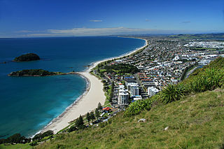
Tauranga is a coastal city in the Bay of Plenty Region and the fifth most populous city of New Zealand, with an urban population of 158,300, or roughly 3% of the national population. It was settled by Māori late in the 13th century, colonised by Europeans in the early 19th century, and was constituted as a city in 1963.
The Tāneatua Branch is a 25 kilometres (16 mi) long branch railway line in the Bay of Plenty, New Zealand, running from Hawkens Junction, west of Edgecumbe, to Tāneatua.
The Murupara Branch is a 57 kilometres (35 mi) long branch railway line from the East Coast Main Trunk (ECMT) at Kawerau to Murupara, built to serve a new pulp and paper mill harvesting the radiata pine trees of the Kaingaroa Forest on the Kaingaroa Plateau in the Bay of Plenty, New Zealand. The line was the last major extension of the New Zealand Railways Department (NZR) network, of 14 kilometres (8.7 mi) from Hawkens Junction, west of Edgecumbe, to Kawerau and 57 km from Kawerau to Murupara. The portion from Hawkens Junction to Kawerau was known as the Kawerau Branch until 1978, when it became part of the ECMT, and the former ECMT from Hawkens Junction to Taneatua became the Taneatua Branch.
The Paeroa-Pokeno railway line or deviation in the upper North Island of New Zealand between Paeroa on the East Coast Main Trunk (ECMT) and Pokeno on the North Island Main Trunk (NIMT) was a proposed route with construction started but abandoned. The proposal has been revived in recent years as part of a more direct route between Auckland and Tauranga.
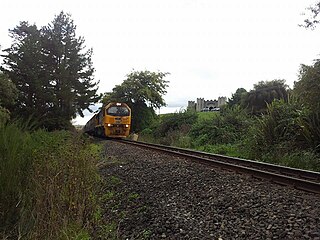
Kairua is a rural area of Tauranga in the Bay of Plenty region of New Zealand's North Island. State Highway 2 runs along its northern side, and crosses it at the northeast. Baypark Stadium is in the northwest of the area. The East Coast Main Trunk railway runs along the south side of SH 2.
