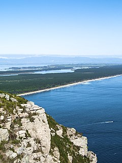
Tauranga Harbour is the natural tidal harbour that surrounds Tauranga CBD and the Mount Maunganui area of Tauranga, New Zealand, and which flows into the Pacific Ocean at Mount Maunganui. The harbour is effectively two flooded river systems separated from the Pacific Ocean by Matakana Island.
The harbour is a large tidal estuary with an area of some 200-km2 and has a tidal range of up to 1.98m. Approximately 290,000,000 tonnes of water flow through the entrances at each tidal change. This tidal flow can generate currents of up to 7 knots within the entrance channels.
The Port of Tauranga is located in the harbour and container ships and cruise ships use the harbour's waters. The Tauranga harbour entrance is the shipping channel to the Port of Tauranga, New Zealand’s largest export port. Shipping movements can take place at any time, day or night, through the main channels.
The Bay of Fundy is a bay between the Canadian provinces of New Brunswick and Nova Scotia, with a small portion touching the US state of Maine. It has an extremely high tidal range. The name is likely a corruption of the French word Fendu, meaning "split".
Cook Strait separates the North and South Islands of New Zealand. The strait connects the Tasman Sea on the northwest with the South Pacific Ocean on the southeast, and runs next to the capital city, Wellington. It is 22 kilometres (14 mi) wide at its narrowest point, and is considered one of the most dangerous and unpredictable waters in the world. Regular ferry services run between Picton in the Marlborough Sounds and Wellington.
Poole Harbour is a large natural harbour in Dorset, southern England, with the town of Poole on its shores. The harbour is a drowned valley (ria) formed at the end of the last ice age and is the estuary of several rivers, the largest being the Frome. The harbour has a long history of human settlement stretching to pre-Roman times. The harbour is extremely shallow, with one main dredged channel through the harbour, from the mouth to Holes Bay.
The Manukau Harbour is the second largest natural harbour in New Zealand by area. It is located to the southwest of the Auckland isthmus, and opens out into the Tasman Sea.
Kaipara Harbour is a large enclosed harbour estuary complex on the north western side of the North Island of New Zealand. The northern part of the harbour is administered by the Kaipara District and the southern part is administered by the Auckland Council. The local Māori tribe is Ngāti Whātua.
Matakana Island is located in the western Bay of Plenty in New Zealand's North Island. A long, flat barrier island, it is 20 kilometres (12 mi) in length but rarely more than 3 kilometres (1.9 mi) wide. The island has been continuously populated for centuries by Māori tribes that are mostly associated with Ngāi Te Rangi.
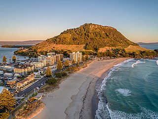
Mount Maunganui is a major residential, commercial and industrial suburb of the Tauranga metropolitan area, located on a peninsula to the north-east of Tauranga's city centre. It was an independent town from Tauranga until the completion of the Tauranga Harbour Bridge in 1988, which connects Mount Maunganui to Tauranga's central business district.
Papamoa or Papamoa Beach is a suburb of Tauranga, located about 11 kilometres from the city centre. It is the largest residential suburb in Tauranga. It is bordered to the west by Arataki and Mount Maunganui, the east by the Kaituna River and to the south by State Highway 2.
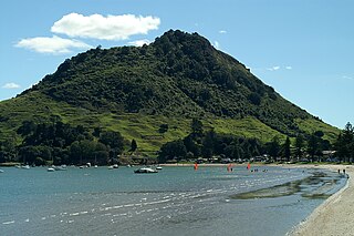
Mount Maunganui, or Mauao, commonly known by locals as The Mount, is an extinct volcanic cone at the end of a peninsula and the town of Mount Maunganui, by the eastern entrance to the Tauranga Harbour in New Zealand. It is considered very important and tapu (sacred) by the local Māori iwi, featuring extensively in local mythology. It is also of significant historical value. The summit is 232 metres above sea level.
The Port of Tauranga is situated in Tauranga, New Zealand. It is the largest port in the country both in terms of total cargo volume, and in terms of container throughput with container volumes exceeding 950,000 TEUs. The port is operated by Port of Tauranga Ltd. This article is about both the company and the port itself.
The Tauranga Harbour Bridge refers to two bridges that carry Te Awanui Drive over the Tauranga Harbour. Te Awanui Drive is part of an expressway that connects Tauranga to Mount Maunganui. On the Tauranga side, Te Awanui Drive connects to Takitimu Drive, which crosses the Chapel Street Viaduct before running along the edge of the Waikareao Estuary. On the Mount Maunganui side, Te Awanui Drive connects to Hewletts Road, which runs through an industrial area towards Maunganui Road.
New Zealand has large ocean energy resources but does not yet generate any power from them. TVNZ reported in 2007 that over 20 wave and tidal power projects are currently under development. However, not a lot of public information is available about these projects. The Aotearoa Wave and Tidal Energy Association was established in 2006 to "promote the uptake of marine energy in New Zealand". According to their 10 February 2008 newsletter, they have 59 members. However, the association doesn't list its members.
The Classic Flyers Museum is an aviation museum located at the Tauranga Airport, Mount Maunganui, New Zealand, owned by a registered New Zealand charitable trust, the Bay of Plenty Classic Aircraft Trust.
The Mount Maunganui branch is a short industrial branch line in Tauranga, New Zealand, servicing the eastern side of the Port of Tauranga. It branches from the East Coast Main Trunk at a triangle junction outside Baypark Stadium before running north-west through Mount Maunganui to the port complex.
Tauranga is a coastal metropolitan city in the Bay of Plenty region and the fifth most populous city of New Zealand, with an urban population of 151,300, or roughly 3% of the national population. It was settled by Māori late in the 13th century, by Europeans in the early 19th century, and was constituted as a city in 1963.
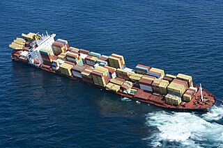
MV Rena was a 3,351 TEU container ship owned by the Greek shipping company Costamare Inc. through one of its subsidiaries, Daina Shipping Co. The ship was built in 1990 as ZIM America for the Israeli shipping company Zim by Howaldtswerke-Deutsche Werft AG in Kiel, Germany. She was renamed Andaman Sea in 2007 and had sailed under her current name and owner since 2010.
The Rena oil spill occurred off the coast of Tauranga, New Zealand in October 2011. The spill was caused by the grounding of MV Rena on the Astrolabe Reef. The Rena was a container ship and cargo vessel owned by the Greek shipping company Costamare Inc., through one of its subsidiary companies Daina Shipping, and chartered by the Mediterranean Shipping Company (MSC). The spill has been described as New Zealand's worst maritime environmental disaster.
Sir Robert Arthur Owens was a Tauranga businessman and was Mayor of both Tauranga and the nearby Mount Maunganui in the Bay of Plenty, New Zealand. He later moved from Mount Maunganui to Auckland. He was knighted in 1997.
Stockton Deepwater Shipping Channel also called the Baldwin-Stockton Deepwater Shipping Channel or Stockton Deep Water Channel is a manmade deepwater water channel that runs from Suisun Bay and the Sacramento River - Sacramento Deep Water Ship Channel to the Port of Stockton and the Stockton Channel in California. The Stockton Ship Channel is 41 mi (66 km) long and about 37 ft (11 m) deep, allowing up to Panama Canal size ocean ships access to the Port of Stockton at the City of Stockton. The Stockton Deepwater Shipping Channel is part of the vast Sacramento–San Joaquin River Delta that has a connection to the Pacific Ocean. Stockton Deepwater Shipping Channel is also called the lower San Joaquin River.
Omanu is a beach and suburb in Mount Maunganui, Tauranga, in the Bay of Plenty Region of New Zealand's North Island.
This page is based on this Wikipedia article Text is available under the CC BY-SA 4.0 license; additional terms may apply. Images, videos and audio are available under their respective licenses.