Tauranga (Māori pronunciation:[ˈtaʉɾaŋa], Māori language for “resting place,” or “safe anchorage")[4][5][6] is a coastal city in the Bay of Plenty region and the fifth-most populous city of New Zealand, with an urban population of 162,800 (June 2024)[3], or roughly 3% of the national population. It was settled by Māori late in the 13th century and colonised by Europeans in the early 19th century. It was constituted as a city in 1963.[7]
The city lies in the north-western corner of the Bay of Plenty, on the south-eastern edge of Tauranga Harbour. The city extends over an area of 141.91 square kilometres (54.79sqmi), and encompasses the communities of Bethlehem, on the south-western outskirts of the city; Greerton, on the southern outskirts of the city; Matua, west of the central city overlooking Tauranga Harbour; Maungatapu; Mount Maunganui, located north of the central city across the harbour facing the Bay of Plenty; Otūmoetai; Papamoa, Tauranga's largest suburb, located in the Bay of Plenty; Tauranga City; Tauranga South; and Welcome Bay.
Tauranga is one of New Zealand's main centres for business, international trade, culture, fashion and horticultural science. The Port of Tauranga is New Zealand's largest port in terms of gross export tonnage and efficiency.[8] Tauranga is one of New Zealand's fastest-growing cities, with an 11% increase in population between the 2006 census and the 2013 census,[9] and 19% between the 2013 and 2018 census. Due to its rapid population growth, Tauranga has become New Zealand's fifth-largest city, overtaking Dunedin and the Napier-Hastings urban areas.
In December 1826 and again in March 1827, the Herald travelled to Tauranga from the Bay of Islands to obtain supplies of potatoes, pigs and flax.[13][14] In 1835 a Church Missionary Society mission station was established at Tauranga by William Wade. Rev. Alfred N. Brown arrived at the CMS mission station in 1838.[15] John Morgan also visited the mission in 1838.[16]
View of waterfront in 1924
Europeans trading in flax were active in the Bay of Plenty during the 1830s; some were transient, others married local women and settled permanently. The first permanent non-Maori trader was James Farrow, who travelled to Tauranga in 1829, obtaining flax fibre for Australian merchants in exchange for muskets and gunpowder. Farrow acquired a land area of 2,000 square metres (1⁄2 acre) on 10 January 1838 at Otūmoetai Pā from the chiefs Tupaea, Tangimoana and Te Omanu, the earliest authenticated land purchase in the Bay of Plenty.[17]
In 1840, a Catholic mission station was established. Bishop Pompallier was given land within the palisades of Otūmoetai Pā for a church and a presbytery. The mission station closed in 1863 due to land wars in the Waikato district.[18]
New Zealand Wars–Tauranga Campaign
The Tauranga Campaign took place in and around Tauranga from 21 January to 21 June 1864, during the New Zealand Wars. The Battle of Gate Pa is the best known.
The Battle of Gate Pā was an attack on the well fortified Pā and its Māori defenders on 29 April 1864 by British forces made up of approximately 300 men of the 43rd Regiment and a naval contingent. The British casualties were 31 dead (including 10 officers), and 80 wounded – the single most devastating loss of life suffered by the British military in the whole of the New Zealand Wars. The Māori defenders abandoned the Pā during the night with casualties estimated at 25 dead and an unknown number of wounded.[19]
Fires
In November 1916, a large fire broke out at the strand destroying 12 buildings, including the Commercial Hotel.[20]
Tauranga Hotel on fire surrounded by large crowd
In 1936 another large fire occurred which started in the hotel's staff quarters and drew large crowds.[21]
Modern era
Under the Local Government (Tauranga City Council) Order 2003,[22] Tauranga became legally a city for a second time, from 1 March 2004.
Tauranga is located around a large harbour that extends along the western Bay of Plenty, and is protected by Matakana Island and the extinct volcano of Mauao (Mount Maunganui). Ngamuwahine River is located 19 kilometres southwest of Tauranga.
View down the strand from the intersection of Harington St in 1924, including Tauranga Hotel and the Farmers' Union Trading Company buildings
Tauranga and the Bay of Plenty are situated along a faultline and so experience (infrequent) seismic activity. There are a few volcanoes around the area (mainly dormant). The most notable of these are White Island and Mauao, nicknamed "The Mount" by locals.
During the summer months the population swells as holidaymakers descend on the city, especially along the popular white coastal surf beaches from Mount Maunganui to Papamoa.
Climate data for Tauranga (1991–2020 normals, extremes 1913–present)
In 1976 Tauranga was a medium-sized urban area with a population of around 48,000. However, the completion of a harbour bridge in 1988 brought Tauranga and The Mount closer (they amalgamated in 1989) and re-energised the economies of both parts of the enlarged city. By 1996 Tauranga's population had grown to 82,092 and by 2006 it had reached 103,635.[28] By 2023, it had reached 152,844.[29]
In 2008 Tauranga overtook Dunedin to become the sixth-largest city in New Zealand by urban area, and the ninth largest city by Territorial Authority area. With continuing growth it has now surpassed the Napier-Hastings area to become New Zealand's fifth-largest city.
Tauranga covers 141.91km2 (54.79sqmi)[2] and had an estimated population of 162,800 as of June 2024,[3] with a population density of 1,147 people per km2.
Tauranga had a population of 152,844 in the 2023 New Zealand census, an increase of 15,714 people (11.5%) since the 2018 census, and an increase of 37,683 people (32.7%) since the 2013 census. There were 73,821 males, 78,558 females and 462 people of other genders in 55,929 dwellings.[31] 2.5% of people identified as LGBTIQ+. The median age was 39.4 years (compared with 38.1 years nationally). There were 29,604 people (19.4%) aged under 15 years, 26,316 (17.2%) aged 15 to 29, 66,786 (43.7%) aged 30 to 64, and 30,138 (19.7%) aged 65 or older.[29]
People could identify as more than one ethnicity. The results were 78.7% European (Pākehā); 19.3% Māori; 3.6% Pasifika; 10.3% Asian; 1.8% Middle Eastern, Latin American and African New Zealanders (MELAA); and 2.1% other, which includes people giving their ethnicity as "New Zealander". English was spoken by 96.2%, Māori language by 4.5%, Samoan by 0.4% and other languages by 12.5%. No language could be spoken by 2.1% (e.g. too young to talk). New Zealand Sign Language was known by 0.4%. The percentage of people born overseas was 25.2, compared with 28.8% nationally.
Of those at least 15 years old, 22,431 (18.2%) people had a bachelor's or higher degree, 64,740 (52.5%) had a post-high school certificate or diploma, and 29,052 (23.6%) people exclusively held high school qualifications. The median income was $42,100, compared with $41,500 nationally. 14,001 people (11.4%) earned over $100,000 compared to 12.1% nationally. The employment status of those at least 15 was that 61,218 (49.7%) people were employed full-time, 17,007 (13.8%) were part-time, and 3,252 (2.6%) were unemployed.[29]
Tauranga is located in the administrative area of the Tauranga City Council. The council consists of the Mayor of Tauranga and nine councillors. The mayor is elected by the city at-large, while the councillors are elected from nine wards (constituencies), each ward electing a single councillor. Elections are held via single transferable vote.[40]
The present nine wards were first established for the 2024 local elections. There are eight general wards (Mauao/Mount Maunganui, Arataki, Pāpāmoa, Welcome Bay, Matua-Otūmoetai, Bethlehem, Tauriko and Te Papa) and one Māori ward (Te Awanui, covering the entire city).[41]
Council elections are usually held every three years, most recently in 2024. The next local election for Tauranga is scheduled for 2028.[42]
In December 2020, the Minister of Local GovernmentNanaia Mahuta announced that, due to alleged "dysfunction" within the elected council, the council would be replaced by commissioners until the 2022 local elections.[43][44] However, then Tauranga MP Simon Bridges said the appointment of commissioners was unnecessary and a "dramatic and draconian step."[45] An independent review by law firm Russell McVeagh found that Mahuta's decision may have been unlawful.[46] Her decision to reappoint the crown commission for a second term in 2022 through to July 2024 was subject to a legal review by Dentons Kensington Swan who found her decision was challengeable on the grounds of unlawfulness and unreasonableness.[47]
Economy
Much of the countryside surrounding Tauranga is horticultural land, used to grow a wide range of fresh produce for both domestic consumption and export. There are many kiwifruit and avocados orchards as well as other crops.
The Port of Tauranga is New Zealand's largest export port. It is a regular stop for both container ships and luxury cruise liners.
Port of Tauranga on the Mount Maunganui side, looking south.Tauranga harbourPicturesque sunrise over the Tauranga harbour
Tauranga's main shopping malls are Bayfair, in Mount Maunganui and Tauranga Crossing in Tauriko. Most of the city's shopping centres are located in the suburbs. They include Fraser Cove, Tauranga Crossing, Bethlehem Town Centre, Papamoa Plaza, Fashion Island, Bayfair Shopping Centre, Bay Central and Greerton Village.
Tauranga has the following business innovation centres
The National Jazz Festival takes place in Tauranga every Easter.[56]
Events
New Year celebrations at the Mount in Mount Maunganui are one of Tauranga's main events, bringing people from all around the country.
In 2014 Tauranga City Council granted permission for an annual Sikh parade to celebrate Guru Gobind Singh's birthday. 2500 people took part in 2014, while in 2015, the number increased to 3500.[57]
Sports
McLaren Falls Park, on the outskirts of Tauranga
Tauranga has a large stadium complex in the Mount Manganui suburb, Baypark Stadium, rebuilt in 2001 after a similar complex closed in 1995. It hosts speedway events during summer and rugby matches in winter.
Tauranga is the home to two rowing clubs – Tauranga Rowing Club in Memorial Park and Bay of Plenty Coast Rowing Club at the picturesque Wairoa River. Both clubs have had successful NZ representation over the years.
Tauranga has an all weather outdoor athletics ground at Tauranga Domain.
Tauranga also has a Hockey Association,[58] separate from the Regional Bay of Plenty body, which represents the city in domestic tournaments.
City facilities and attractions
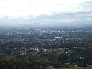
View over Greater Tauranga, taken from the top of Mauao
Greater Tauranga is a very popular lifestyle and tourism destination. It features many natural attractions and scenery ranging from popular beaches and harbour environments to lush bush-clad mountains with waterfalls and lakes.
View of Mount Beach, with Mauao in background
Cultural attractions include the Tauranga Art Gallery, which opened in October 2007 and showcases local, national and international exhibitions in a range of media. On the 17th Avenue, the "Historic Village on 17th",[59] recreates a historic setting with original and replica buildings from early Tauranga housing arts and gift shops.
The Baycourt Community and Arts Centre is a multi-purpose performing arts and theatre facility located in the central business district.
Aviation interests are well served with the Classic Flyers Museum and the Gyrate Flying Club where you can experience flying a modern gyroplane; the "motorbike of the sky".[60]
Tauranga has many parks: one of the largest is Memorial Park, and others include Yatton Park, Kulim Park, Fergusson Park and the large Tauranga Domain. The Te Puna Quarry Park has become a regional attraction, known for being converted from a disused quarry into a community park.[61]
Due to the temperate climate, outdoor activities are very popular, including golf, tramping (hiking), mountain biking and white water rafting. The Bay of Plenty coastline has miles of golden sandy beaches, and watersports are very popular, including swimming, surfing, fishing, diving, kayaking and kitesurfing. Tourists also enjoy dolphin-watching on specially run boat trips.
The coastal suburb Papamoa and neighbouring Mount Maunganui are some of the more affluent areas in Tauranga. The region's beaches attract swimmers, surfers, kayakers and kitesurfers throughout the year.
Tauranga has many outlying islands and reefs that make it a notable tourist destination point for travelling scuba divers and marine enthusiasts.[62] Extensive marine life diversity is available to scuba divers all year round. Water temperatures range from 12 degrees Celsius in winter to 22–24 degrees Celsius in summer. Tauranga houses two professional dive instructor training centres, training NAUI, PADI and SSI dive leader systems.
Infrastructure
Hospitals
Tauranga Hospital is a public secondary regional hospital located in Tauranga South, with 360 beds including neonatal, geriatric, surgical, maternity and mental health care.[63] It provides elective and emergency healthcare across medical, surgical, paediatric, obstetric, gynaecological and psychiatric services. The main tertiary referral centre for Tauranga Hospital is Waikato Hospital, located in Hamilton. As the site of the Bay of Plenty Clinical School, Tauranga Hospital provides training to medical students from the University of Auckland, as well as selective and elective placements for nursing and midwifery students.[64]
Grace Hospital is Tauranga's only private specialist surgical hospital, located in Oropi. It accommodates 6 operating theatres, 48 inpatient beds, a two-bed HDU, a procedure room for minor surgery and two procedure rooms for endoscopy.[65]
Natural gas arrived in Tauranga in 1982, following the completion of the high-pressure pipeline from the Maui pipeline near Te Awamutu to the city, now operated by First Gas.[67] First Gas also operates the gas distribution network within the city.
From 24 October 2024, the Tauranga City Council began flouridating the city's water supply in response to a directive from the Director-General of Health.[68]
Transport
A KiwiRail train on the East Coast Main Trunk Railway which runs through the central city.
Tauranga City Council is currently responsible for approximately 530km of roads, 700km of footpaths, cycle ways and access ways.[69]
Tauranga City Council also has a bit of work under way with their Transportation and Roads strategy. Their aim for the future to change current travel behaviour from a focus on private cars to more sustainable modes such as buses, cycling and walking.
Tauranga has no passenger rail network, however it is a busy freight rail hub due to distribution from the Port of Tauranga.
Bus
Main transportation in the city is provided by the BayBus, with twelve routes servicing the city's population. Bay Hopper buses depart the central stops in Tauranga's CBD, Ohauiti, Mount Maunganui and Bayfair every 15 minutes, with the routes to Papamoa and Greerton half-hourly.[70]Bee Cards were introduced for fares on 27 July 2020.[71]
The city is also a waypoint for bus travel between cities, with the Bay Hopper, and Intercity having a daily schedule.
Sea
Tauranga has a passenger ferry service that transports passengers from Tauranga CBD to Mount Maunganui's Salisbury wharf. It is a 2-Way service that costs $15 each way.[72][73]
The organisations currently share two main campuses, but are planning a new central campus. Stage 1 was expected to be open in 2017, catering for 500 but with capacity for 700, which cost $67.3 million.[75][76]
Pāpāmoa College, co-educational secondary school opened in 2011 for years 7–13.
Te Wharekura o Mauao,[80] a co-educational wharekura-ā-iwi total immersion Māori secondary school for Years 7–13, founded in 2010, with around 200 students.
Te Kura Kaupapa Māori o Te Kura Kōkiri, a co-educational kura kaupapa Māori total immersion school for Years 1–13, founded in 2000, with around 140 students.
Greater Wellington, also known as the Wellington region, is a non-unitary region of New Zealand that occupies the southernmost part of the North Island. The region covers an area of 8,049 square kilometres (3,108 sq mi), and has a population of 550,600.
The North Shore is one of the major geographical regions of Auckland, the largest city in New Zealand. The area is defined as the northern shores of the Waitematā Harbour as far north as the Ōkura River.
The South Wairarapa District is a district at the south-east tip of the North Island of New Zealand, governed by the South Wairarapa District Council. The district comprises the southernmost part of the Wairarapa, and is part of the Wellington Region.
Tasman District is a local government district in the northwest of the South Island of New Zealand. It borders the Canterbury Region, West Coast Region, Marlborough Region and Nelson City. It is administered by the Tasman District Council, a unitary authority, which sits at Richmond, with community boards serving outlying communities in Motueka and Golden Bay / Mohua. The city of Nelson has its own unitary authority separate from Tasman District, and together they comprise a single region in some contexts, but not for local government functions or resource management (planning) functions.
Mount Wellington is a suburb in East Auckland, New Zealand, located 10 km (6.2 mi) southeast of the city centre. It is surrounded by the suburbs of Stonefields, Tamaki, Panmure, Penrose, and Ellerslie, and by the Tāmaki River. The suburb is named after the volcanic peak of Maungarei / Mount Wellington. Sylvia Park is a large business park and shopping centre located in the suburb.
The Thames-Coromandel District is a territorial authority district in the North Island of New Zealand, covering all the Coromandel Peninsula and extending south to Hikutaia.
Hauraki District is a territorial authority governed by the Hauraki District Council within the Waikato region of New Zealand. The seat of the council is at Paeroa.
Western Bay of Plenty District is a territorial district within the Bay of Plenty Region of New Zealand. The district envelops Tauranga city by land, and includes Matakana Island, at the entrance to Tauranga Harbour.
Kawerau is a town in the Bay of Plenty Region on the North Island of New Zealand. It is situated 100 km south-east of Tauranga and 58 km east of Rotorua. It is the seat of the Kawerau District Council, and the only town in Kawerau District.
Southland District is a New Zealand territorial authority district that covers most of the southern end of the South Island as well as Stewart Island.
Hastings District is a Territorial authority district within the Hawke's Bay Region, on the east coast of the North Island of New Zealand. It covers the southern half of the Hawke's Bay coast, excluding Napier City, which is a separate territorial authority. Hastings District Council is headquartered in the city of Hastings, the district's largest town.
Westland District is a territorial authority district on the West Coast of New Zealand's South Island. It is administered by the Westland District Council. The district's population is 9,430.
Massey is a northern suburb in West Auckland, New Zealand. It was formerly a northern suburb of Waitakere City, which existed from 1989 to 2010 before the city was amalgamated into Auckland Council. The suburb was named after former Prime Minister of New Zealand William Massey. Massey is a relatively large suburb and can be divided into three reasonably distinctive areas, Massey West, Massey East and Massey North. Parts of Massey East are also known as 'Royal Heights', which is home to the Royal Heights shopping centre.
Taupō District is a territorial authority district in New Zealand. It covers 6,333 km² of land, and a further 610 km² of lake area, including Lake Taupō, New Zealand's largest lake, and Lake Rotoaira. The district stretches from the small town of Mangakino in the northwest to the Tongariro National Park in the south, and east into the Kaingaroa Forest. The district's population is largely located in the two main centres, Taupō and Tūrangi.
The Auckland isthmus, also known as the Tāmaki isthmus, is a narrow stretch of land on the North Island of New Zealand in the Auckland Region, and the location of the central suburbs of the city of Auckland and the central business district. The isthmus is located between two rias : the Waitematā Harbour to the north, which opens to the Hauraki Gulf / Tīkapa Moana and Pacific Ocean, and the Manukau Harbour to the south, which opens to the Tasman Sea. The isthmus is the most southern section of the Northland Peninsula.
Rotorua Lakes District or Rotorua District is a territorial authority district in the North Island of New Zealand. It has one urban area of significant size, the city of Rotorua. The district is governed by Rotorua Lakes Council, which is headquartered in Rotorua and is headed by a mayor. The district falls within two regional council areas, with the majority of the area and Rotorua city in the Bay of Plenty Region and the rest in the Waikato region. Tania Tapsell has been the mayor of Rotorua since the 2022 local elections.
Whangarei District is a territorial authority district in the Northland Region of New Zealand that is governed by the Whangarei District Council. The district is made up in area largely by rural land, and includes a fifth of the Northland Region. It extends southwards to the southern end of Bream Bay, northwards to Whangaruru and almost to the Bay of Islands, and westwards up the Mangakahia River valley past Pakotai and almost to Waipoua Forest. It includes the Hen and Chicken Islands and the Poor Knights Islands.
Wairoa District is a territorial authority district within the Hawke's Bay Region in the North Island of New Zealand. The Wairoa District Council is headquartered in the largest town, Wairoa. The district covers the northern half of the Hawke's Bay coast, extending from Māhia Peninsula to Lake Waikaremoana, and south to the mouth of the Waikare River.
Whakatāne District is a territorial authority district on the North Island of New Zealand. The Whakatāne District Council is headquartered in the largest town, Whakatāne. The district falls within the Bay of Plenty Region. Victor Luca has been the mayor of Whakatāne since the 2022 local elections.
West Auckland is one of the major geographical areas of Auckland, the largest city in New Zealand. Much of the area is dominated by the Waitākere Ranges, the eastern slopes of the Miocene era Waitākere volcano which was upraised from the ocean floor, and now one of the largest regional parks in New Zealand. The metropolitan area of West Auckland developed between the Waitākere Ranges to the west and the upper reaches of the Waitematā Harbour to the east. It covers areas such as Glen Eden, Henderson, Massey and New Lynn.
↑ Cowan, James (1922). "42, Gate Pa and Te Ranga". The New Zealand Wars: A History of the Maori Campaigns and the Pioneering Period, Vol. 1, 1845–1864. Wellington: RNZ Government Printer.
This page is based on this Wikipedia article Text is available under the CC BY-SA 4.0 license; additional terms may apply. Images, videos and audio are available under their respective licenses.