Related Research Articles

Western Bay of Plenty District is a territorial authority within the Bay of Plenty Region of New Zealand. The district envelops Tauranga City by land, and includes Matakana Island, at the entrance to Tauranga Harbour.
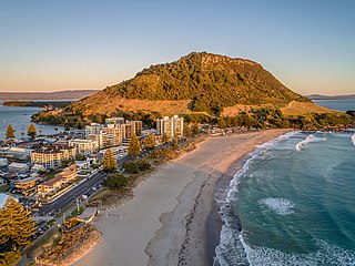
Mount Maunganui is a major residential, commercial and industrial suburb of the Tauranga metropolitan area, located on a peninsula to the north-east of Tauranga's city centre. It was an independent town from Tauranga until the completion of the Tauranga Harbour Bridge in 1988, which connects Mount Maunganui to Tauranga's central business district.

Papamoa or Papamoa Beach is a suburb of Tauranga, located about 11 kilometres from the city centre. It is the largest residential suburb in Tauranga. It is bordered to the west by Arataki and Mount Maunganui, the east by the Kaituna River and to the south by State Highway 2.

Ngāti Pūkenga is a Māori iwi centred in Tauranga in the Bay of Plenty region of New Zealand. Its rohe extends to Mayor Island / Tuhua and Waihi in the north, to the Kaimai Range in the west, south of Te Puke and to Maketu in the east, and it has tribal holdings in Whangarei, Hauraki and Maketu.

State Highway 2 runs north–south through eastern parts of the North Island of New Zealand from the outskirts of Auckland to Wellington. It runs via Tauranga in the Bay of Plenty, Gisborne, and Napier and Hastings in Hawke's Bay. It is the second-longest highway in the North Island, after State Highway 1, which runs the length of both of the country's main islands.
The Tauranga Eastern Link (TEL) is a four lane motorway in the Bay of Plenty region in New Zealand, covering 23 km from Te Maunga junction in Tauranga to Paengaroa. It was officially opened on 30 July 2015. It replaced a section of State Highway 2, improving access to Tauranga from the east and south. It became the main route for trucks heading to the Port of Tauranga from Rotorua and the eastern Bay of Plenty, and connected the Central Plateau forestry industry with the port to facilitate lumber export.

The Bay of Plenty is a region of New Zealand, situated around a bight of the same name in the northern coast of the North Island. The bight stretches 260 km from the Coromandel Peninsula in the west to Cape Runaway in the east. The Bay of Plenty Region, governed by the Bay of Plenty Regional Council, incorporates several large islands in the bay, in addition to the mainland area. Called Te Moana-a-Toi in the Māori language after Toi, an early ancestor, the name 'Bay of Plenty' was bestowed by James Cook in 1769 when he noticed the abundant food supplies at several Māori villages there, in stark contrast to observations he had made earlier in Poverty Bay.

Tauranga is a coastal metropolitan city in the Bay of Plenty region and the fifth most populous city of New Zealand, with an urban population of 151,300, or roughly 3% of the national population. It was settled by Māori late in the 13th century, by Europeans in the early 19th century, and was constituted as a city in 1963.

Pukehina is a beach and township located in the Western Bay of Plenty District and Bay of Plenty Region of New Zealand's North Island. It consists of a white sandy beach, an estuary, farms and several homes. The area is popular with surfing, windsurfing and kite surfing. There is a campground located at the south-eastern end of the beach, and a boat ramp at the estuary.

State Highway 29 (SH 29) is a New Zealand state highway that travels over the Kaimai Ranges linking the Bay of Plenty and Waikato regions. For most of its length, SH 29 is a two-lane single carriageway with occasional passing lanes and slow vehicle bays. 5 km of it near its eastern terminus is part of the Takitimu Drive Toll Road.
Tauranga South is a suburb of Tauranga, on New Zealand's North Island. It is located south-east of Judea, north-east of Gate Pa and south-west of Tauranga Central.
Otamarakau is a beach and community in the Western Bay of Plenty District and Bay of Plenty Region of New Zealand's North Island, just south of Pukehina.
Omanu is a beach and suburb in Mount Maunganui, Tauranga, in the Bay of Plenty Region of New Zealand's North Island.
Bellevue is a suburb of Tauranga, in the Bay of Plenty Region of New Zealand's North Island.
Arataki is a neighbourhood of Mount Maunganui Tauranga, in the Bay of Plenty Region of New Zealand's North Island.

The Bay of Plenty District Health Board is a district health board with the focus on providing healthcare to the Bay of Plenty area of New Zealand.

Poroporo is a rural community in the Whakatāne District and Bay of Plenty Region of New Zealand's North Island. It is located south-west of Whakatāne, inland from the settlement.
Whakamarama is a rural area in the Western Bay of Plenty District and Bay of Plenty Region of New Zealand's North Island.
Pahoia is a waterfront settlement in the Western Bay of Plenty District and Bay of Plenty Region of New Zealand's North Island.
References
- ↑ Evans, Alisha. "Smoke from Te Maunga fire 'not toxic'". Sun Live. Sun Media.
- ↑ "Surface flooding causes issues in Tauranga". New Zealand Media and Entertainment. Bay of Plenty Times. 26 June 2020.
- ↑ "Significant changes ahead for SH2/SH29A Te Maunga intersection junction". New Zealand Media and Entertainment. Bay of Plenty Times. 24 September 2020.
Coordinates: 37°40′59″S176°13′46″E / 37.682961°S 176.229468°E
| | This Bay of Plenty geography article is a stub. You can help Wikipedia by expanding it. |