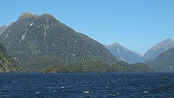
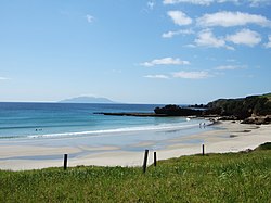
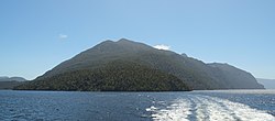
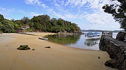
| Name | Image | Map | Area (ha) [7] | Date created | Notes |
|---|
| Akaroa Marine Reserve |  |  | 512 | 2014 | Covers an area around the eastern side of the entrance to Akaroa Harbour, known for marine mammals including Hector's dolphins, whales, and seals. [8] |
| Auckland Islands - Motu Maha Marine Reserve |  |  | 498,000 | 2003 | Covers a range of marine environments in the water around the Auckland Islands. |
| Cape Rodney-Okakari Point Marine Reserve |  |  | 547 | 1975 | The first marine reserve to be established in New Zealand. |
| Hautai Marine Reserve [9] | |  | 853 | 2014 | Located in a remote corner of New Zealand's West Coast, making it the most remote marine reserve on New Zealand's main archipelago. |
| Hawea (Clio Rocks) Marine Reserve | |  | 411 | 2005 | Covers the inner reaches of Hāwea / Bligh Sound. |
| Hikurangi Marine Reserve [10] |  |  | 10,416 | 2014 | Deepest marine reserve around the mainland of New Zealand, covering a large area of the Kaikōura Canyon and Hikurangi Trough. |
| Horoirangi Marine Reserve |  |  | 904 | 2005 | Also known as the Glenduan Marine Reserve, covers the eastern side of Tasman Bay and protects a unique transition zone with a range of reef-dwelling species. |
| Kahukura (Gold Arm) Marine Reserve | |  | 464 | 2005 | Protects the entirety of the Gold Arm of Taiporoporo / Charles Sound, which includes a range of red and black corals [11] |
| Kahurangi Marine Reserve [12] |  |  | 8,419 | 2014 | |
| Kapiti Marine Reserve |  |  | 2,167 | 1992 | |
| Kermadec Islands Marine Reserve |  |  | 748,000 | 1990 | |
| Kutu Parera (Gaer Arm) Marine Reserve |  |  | 433 | 2005 | |
| Long Bay-Okura Marine Reserve |  |  | 980 | 1995 | |
| Long Island-Kokomohua Marine Reserve |  |  | 619 | 1993 | |
| Moana Uta (Wet Jacket Arm) Marine Reserve |  |  | 2,007 | 2005 | |
| Motu Manawa-Pollen Island Marine Reserve |  |  | 501 | 1995 | |
| Moutere Hauriri / Bounty Islands Marine Reserve [13] [14] |  |  | 104,626 | 2014 | |
| Moutere Ihupuku / Campbell Island Marine Reserve [13] [14] |  |  | 290,000 | 2014 | |
| Moutere Mahue / Antipodes Island Marine Reserve [13] [14] |  |  | 217,287 | 2014 | |
| Parininihi Marine Reserve |  |  | 1,844 | 2006 | |
| Piopiotahi (Milford Sound) Marine Reserve |  |  | 690 | 1993 | |
| Pohatu Marine Reserve (Flea Bay) | |  | 215 | 1999 | |
| Poor Knights Islands Marine Reserve |  |  | 1,890 | 1981 | |
| Punakaiki Marine Reserve [15] |  |  | 3,520 | 2014 | |
| Taipari Roa (Elizabeth Island) Marine Reserve |  |  | 613 | 2005 | |
| Tapuae Marine Reserve |  |  | 1,404 | 2008 | |
| Taputeranga Marine Reserve |  |  | 855 | 2008 | |
| Taumoana (Five Finger Peninsula) Marine Reserve |  |  | 1,466 | 2005 | |
| Tauparikākā Marine Reserve [16] |  |  | 17 | 2014 | |
| Tāwharanui Marine Reserve [17] |  |  | 394 | 2011 | |
| Te Angiangi Marine Reserve | |  | 446 | 1997 | |
| Te Awaatu Channel (The Gut) Marine Reserve |  |  | 93 | 1993 | |
| Te Hapua (Sutherland Sound) Marine Reserve | |  | 449 | 2005 | |
| Te Matuku Marine Reserve | |  | 690 | 2005 | |
| Te Paepae o Aotea (Volkner Rocks) Marine Reserve | |  | 1,267 | 2006 | |
| Te Tapuwae o Hua (Long Sound) Marine Reserve |  |  | 3,672 | 2005 | |
| Te Tapuwae o Rongokako Marine Reserve | |  | 2,452 | 1999 | |
| Tonga Island Marine Reserve |  |  | 1,835 | 1993 | |
| Tuhua (Mayor Island) Marine Reserve |  |  | 1,060 | 1992 | |
| Ulva Island - Te Wharawhara Marine Reserve |  |  | 1,075 | 2004 | |
| Waiau Glacier Coast Marine Reserve [18] | |  | 4,557 | 2014 | |
| Westhaven (Te Tai Tapu) Marine Reserve |  |  | 536 | 1994 | |
| Whanganui A Hei (Cathedral Cove) Marine Reserve |  |  | 840 | 1993 | |
| Whangarei Harbour Marine Reserve |  |  | 237 | 2006 | Protects two separate areas within Whangārei Harbour: an intertidal mudflat and mangrove forest at Waikaraka, and the waters around Motukaroro / Passage Island. Was established following efforts by students from Kamo High School. [19] |


