Wenderholm Regional Park

Last updated

Wenderholm Regional Park
Wenderholm3.jpg
Wenderholm beach to north
NZ-Auckland plain map.png
Disc Plain red.svg
Location Rodney, Auckland, New Zealand
Nearest town Waiwera
Coordinates 36°32′13″S174°42′36″E / 36.537°S 174.71°E / -36.537; 174.71 [1]
Area135 hectares (330 acres) [3]
Established1965

Wenderholm Regional Park is a regional park north of Auckland in New Zealand's North Island. It is situated between the estuaries of the Puhoi River and the Waiwera River, on the east coast of New Zealand's North Island and features a homestead known as Couldrey House , and a carved pouwhenua. [4]

Contents

The park also features the 2 kilometres (1.2 mi) 'Maungatauhoro Te Hikoi' walking track, starting at the carved pouwhenua near the Couldrey House. The track features scenic views and birdlife. [5] [6]

Wenderholm Regional Park was the first regional park established in the Auckland region, and is owned and managed by Auckland Council. Part of the park is sectioned off for ecological restoration. [7]

Geography

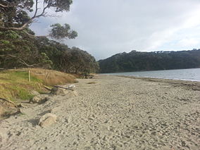
Wenderholm Regional Park is a peninsula between the Puhoi River to the north and the Waiwera River to the south. There are two major sections of the park: a sandspit at the mouth of the Puhoi River, and the Maungatauhoro headland, which is covered by bush. [3]

Biodiversity

North Island robin, recently reintroduced at the park NZ North Island Robin-3.jpg
North Island robin, recently reintroduced at the park

A 60 hectares (150 acres) section of the park has been set aside since 1965 for an ecological experiment, stopping livestock from grazing and repopulating the forests. This allowed native species of birds which were no longer in the area to be re-introduced in 1999. One of the first species released into the area, Petroica australis ssp. longipes (North Island robins), has a generally high rate of survival and procreated a good number of young, unfortunately not high enough to compensate for the loss of the adult population. [8] Tūī, kererū and New Zealand fantails are all commonly found in the park. [3]

Whales such as southern right whales may appear to rest and calve along the coasts. Dolphins may be visible from the shores as well. [7]

The native bush of the park prominently features pōhutukawa, with the blaze of red in the summer, on the slopes facing north is the kōwhai bush which are covered with yellow blooms in the spring, and the low-laying sandspit. [4] [9] The Maungatauhoro headland forest includes tree species such as tawa, kohekohe, taraire, tōtara, nīkau palms, kahikatea and rimu. [3]

Australian kookaburras can occasionally be found in the regional park, having been introduced to Kawau Island in the 19th century. [3]

History

For approximately 1,000 years Māori lived in the area now encompassed by the park because it featured several natural resources. It was generally known as Te Awa Puhoi or 'The slow flowing river'. [10] Te Kawerau related tribes lives in the area, settling in locations such as Te Akeake, a kāinga at the mouth of the Puhoi Estuary and Kakaha , a defensive outpost located at the highest point of the peninsula, Maungatauhoro / Wenderholm Hill. [11]

The Auckland politician and entrepreneur Sir Robert Graham protected many of the ancient trees in the area from felling to be used for timber for ships. [12] He went on to build a homestead in the park (now known as the Couldrey House), in the late 1850s. [11] [3] Many of the historic trees in the park were given as gifts to Robert Graham from George Grey. [4] The name Wenderholm was the name given to Graham's residence. [11]

Graham planted many exotic species of plant at his home, and preserved a 19th-century grove of pōhutukawa trees in the 1880s. [11] Graham sold the land, and the homestead became known as the Couldrey House, named for its final owner, Herbert William Couldrey. [11]

In the 1960s, Herbert William Couldrey had attempted to subdivide the land at Wenderholm for lifestyle blocks. Despite being approved by the Rodney County Council the Auckland Regional Authority appealed the decision and acquired the land for £185,000 on 31 March 1965 under eminent domain. Wenderholm was opened as the first regional park of Auckland following this. [13] [14] [15]

Recreation

The Puhoi River is a popular spot for kayakers. [3]

Related Research Articles

<span class="mw-page-title-main">East Coast Bays</span> Area of the North Shore, Auckland, New Zealand

East Coast Bays is a string of small suburbs that form the northernmost part of the North Shore, part of the contiguous Auckland metropolitan area in New Zealand. The suburbs line the north-east coast of the city along the shore of the Hauraki Gulf and Rangitoto Channel. They include, from north to south, Long Bay, Torbay, Waiake Bay, Browns Bay, Rothesay Bay, Murrays Bay, Mairangi Bay, Campbells Bay and Castor Bay. Most of the East Coast Bays are covered under the East Coast Bays subdivision of the Hibiscus and Bays local board area.

<span class="mw-page-title-main">Takapuna</span> Suburb in Auckland, New Zealand

Takapuna is a suburb located on the North Shore of Auckland, New Zealand. The suburb is an isthmus between Shoal Bay, arm of the Waitematā Harbour, and the Hauraki Gulf. Lake Pupuke, a volcanic maar and one of the oldest features of the Auckland volcanic field, is a freshwater lake located in the suburb.

<span class="mw-page-title-main">Clevedon, New Zealand</span> Town in Auckland Region, New Zealand

Clevedon, previously known as Wairoa South, is a rural town to the south-east of Auckland, New Zealand, in the local government area of Franklin. The area is part of the rohe of Ngāi Tai ki Tāmaki, who settled around the Wairoa River. The original township was founded in the 1850s, and was named Clevedon in 1866. Over time, it has developed into a centre for the dairy industry south-east of Auckland.

<span class="mw-page-title-main">Kawau Island</span> Island in the Hauraki Gulf, in Auckland, New Zealand

Kawau Island is in the Hauraki Gulf, close to the north-eastern coast of the North Island of New Zealand. At its closest point it lies 1.4 km (0.87 mi) off the coast of the Northland Peninsula, just south of Tāwharanui Peninsula, and about 8 km (5.0 mi) by sea journey from Sandspit Wharf, and shelters Kawau Bay to the north-east of Warkworth. It is 40 km (25 mi) north of Auckland. Mansion House in the Kawau Island Historic Reserve is an important historic tourist attraction. Almost every property on the Island relies on direct access to the sea. There are only two short roads serving settlements at Schoolhouse Bay and South Cove, and most residents have private wharves for access to their front door steps.

<span class="mw-page-title-main">Torbay, New Zealand</span> Suburb in Auckland, New Zealand

Torbay is a northern suburb of Auckland, New Zealand. It is located in the upper East Coast Bays of the city's North Shore, and is governed by Auckland Council.

<span class="mw-page-title-main">Hibiscus Coast</span> Stretch of the Hauraki Gulf

The Hibiscus Coast is a populated area on a stretch of the Hauraki Gulf coast in New Zealand's Auckland Region. It has a population of 69,070, making it the 10th most populous urban area in New Zealand, and the second most populous in the Auckland Region, behind Auckland itself. As an urban area delineated by Statistics New Zealand, the Hibiscus Coast consists of Hatfields Beach, Orewa, Silverdale and Whangaparāoa Peninsula. The Auckland Council's Hibiscus Coast subdivision of the Hibiscus and Bays includes the neighbouring communities of Waiwera and Stillwater, and Milldale in Rodney, is also described as a part of the Hibiscus Coast.

<span class="mw-page-title-main">Waiwera</span> Place in Auckland Region, New Zealand

Waiwera is a small town in the north of the Auckland Region in New Zealand. Waiwera is 6 km north of Orewa, 6 km south-east of Puhoi, 23 km south-east of Warkworth and approximately 35 km from the Auckland City centre. The settlement lies at the outlet of a river also called Waiwera. Less than 1 kilometre north of the Waiwera turn-off lies the turn-off to Wenderholm Regional Park which is situated on the far side of the headland to the north of the Waiwera River outlet.

<span class="mw-page-title-main">Duder Regional Park</span>

Duder Regional Park is a regional park situated on the coast to the east of Auckland, New Zealand, on the Whakakaiwhara Peninsula.

<span class="mw-page-title-main">Long Bay, New Zealand</span> Suburb in Auckland, New Zealand

Long Bay is one of the northernmost suburbs of the North Shore, part of the contiguous Auckland metropolitan area located in New Zealand.

<span class="mw-page-title-main">Long Bay Regional Park</span> Park in Auckland, New Zealand

Long Bay Regional Park is a regional park in Long Bay located in Auckland, New Zealand. It is located in the Hibiscus and Bays in the northern part of the city and is operated by Auckland Council.

<span class="mw-page-title-main">Puhoi River</span> River in the Auckland Region, New Zealand

The Puhoi River is a river of the Auckland Region of New Zealand's North Island. It flows southeast from its sources 10 kilometres (6 mi) southwest of Warkworth, passing through the town of Puhoi before reaching the coast of Whangaparaoa Bay seven kilometres north of Orewa.

<span class="mw-page-title-main">Geology of the Auckland Region</span>

The Auckland Region of New Zealand is built on a basement of greywacke rocks that form many of the islands in the Hauraki Gulf, the Hunua Ranges, and land south of Port Waikato. The Waitākere Ranges in the west are the remains of a large andesitic volcano, and Great Barrier Island was formed by the northern end of the Coromandel Volcanic Zone. The Auckland isthmus and North Shore are composed of Waitemata sandstone and mudstone, and portions of the Northland Allochthon extend as far south as Albany. Little Barrier Island was formed by a relatively isolated andesitic volcano, active around 1 to 3 million years ago.

<span class="mw-page-title-main">Scandrett Regional Park</span> Public park in Auckland, New Zealand

Scandrett Regional Park is a regional park located on the north east tip of the Mahurangi Peninsula, north of the city of Auckland, New Zealand. It encompasses Mullet Point and includes regenerating coastal forest, rocky headlands that protrude into Kawau Bay, Scandretts Bay beach and a precinct of historic farm buildings. The people of Auckland own the park through the Auckland Council.

<span class="mw-page-title-main">Āwhitu Regional Park</span>

Āwhitu Regional Park is a regional park situated on the Āwhitu Peninsula, just south of Manukau Heads on the western side of the Manukau Harbour. It is situated in Franklin in Auckland in New Zealand's North Island, and is administered by Auckland Council.

<span class="mw-page-title-main">Tāpapakanga Regional Park</span> New Zealand regional park

Tāpapakanga Regional Park is a regional park situated in the Auckland Region of New Zealand's North Island. It is located in Franklin, east of Kawakawa Bay, and is owned and operated by Auckland Council.

<span class="mw-page-title-main">Tāwharanui Regional Park</span>

Tāwharanui Regional Park is a regional park on the Tāwharanui Peninsula in the Auckland Region of New Zealand's North Island. It is located in Rodney, east of Warkworth and north of Auckland.

<span class="mw-page-title-main">Waiwera River (Auckland)</span> River in the Auckland Region, New Zealand

The Waiwera River is a stream of the Auckland Region of New Zealand's North Island, near the township of Waiwera.

<span class="mw-page-title-main">Mahurangi Island</span> Island in New Zealand

Mahurangi Island, is an island at the mouth of the Waiwera River, in the Auckland Region, New Zealand.

<span class="mw-page-title-main">Te Muri Regional Park</span> Regional park in Auckland, New Zealand

Te Muri Regional Park is a regional park north of Auckland in New Zealand's North Island. It is situated between the estuaries of the Puhoi River and Te Muri-O-Tarariki Stream, on the east coast of New Zealand's North Island. The park is bordered by two other regional parks: Mahurangi West Regional Park to the north, and Wenderholm Regional Park to the south.

<span class="mw-page-title-main">Couldrey House</span> Mid-19th century historic homestead, Wenderholm Regional Park, New Zealand

Couldrey House is a mid-19th century historic homestead located in the Wenderholm Regional Park. Couldrey House was originally built and owned by Robert Graham. The house has hosted many notable individuals including Queen Elizabeth II. In the 1980s the house was opened to the public and it currently functions as a museum.

References

  1. "Wenderholm Map" (PDF). Auckland Council. Retrieved 15 May 2012.
  2. "Wenderholm Map" (PDF). Auckland Council. Retrieved 15 May 2012.
  3. 1 2 3 4 5 6 7 Janssen, Peter (January 2021). Greater Auckland Walks. New Holland Publishers. p. 31-32. ISBN   978-1-86966-516-6. OL   34023249W. Wikidata   Q118136068.
  4. 1 2 3 "Wenderholm". Auckland Council. Retrieved 1 September 2011.
  5. Auckland Regional Park about Maungatauhoro
  6. Maungatauhoro Te Hikoi at scoopnews
  7. 1 2 "Council profile". aucklandcouncil.govt.nz. Auckland Council.
  8. Lovegrove, TG; Zeiler,CH; Green,BS; Green,BW; Gaastra,R and MacArthur,AD (2002). "Alien plant and animal control and aspects of ecological restoration in a small 'mainland island':Wenderholm Regional Park, New Zealand". Turning the Tide: The Eradication of Invasive Species: Proceedings of the International Conference on Eradication of Island Invasives: 155–163. ISBN   2-8317-0682-3.{{cite journal}}: CS1 maint: multiple names: authors list (link)
  9. "Hauraki Gulf Review" . Retrieved 27 September 2011.
  10. Monk, Valerie (2004). A visitor's guide do Auckland regional parks. New Holland.
  11. 1 2 3 4 5 Cameron, Ewen; Hayward, Bruce; Murdoch, Graeme (2008). A Field Guide to Auckland: Exploring the Region's Natural and Historical Heritage. Random House New Zealand. p. 121. ISBN   978-1-86962-1513.
  12. Gregory, Angela (3 May 2008). "Moon shines in regional park". The New Zealand Herald. Retrieved 6 September 2011.
  13. "Wenderholm Regional Park" (PDF). Auckland Council. Retrieved 25 July 2024.
  14. "Beach Playground". Press. No. 30938. 20 December 1965.
  15. Murdoch, Graeme (2010). Dreamers of the Day: a History of Auckland's Regional Parks. Auckland Regional Council. p. 14. ISBN   978-1-86979-332-6.