Egmont National Park is located south of New Plymouth, close to the west coast of the North Island of New Zealand. The park covers three volcanic cones: Mount Taranaki and its slopes, Pouakai and Kaitake. The park was first created in 1881 as a forest reserve and went on to become New Zealand’s second national park, preceded by Tongariro National Park, in 1900.
Kahurangi Point is a headland on the West Coast of New Zealand's South Island, overlooking the Tasman Sea. It is located in Kahurangi National Park between Karamea and Farewell Spit.

New Zealand has 44 marine reserves spread around the North, the South Island, and neighbouring islands, and on outlying island groups. They are governed by the Marine Reserves Act 1971 and administered by the Department of Conservation with assistance from the Ministry for Primary Industries, New Zealand Customs Service and the New Zealand Defence Forces.

The Poor Knights Islands Marine Reserve is a protected area off the coast of the North Island of New Zealand. The reserve, established in 1981 and covering an area of 1,890 ha, is administered by the Department of Conservation. It surrounds the Poor Knights Islands and adjacent rock stacks Sugarloaf Rock and High Peak Rocks. It is one of the world's ten most popular sites for scuba diving. with dive trips regularly leaving from the town of Tutukaka.

Protected areas of New Zealand are areas that are in some way protected to preserve their environmental, scientific, scenic, historical, cultural or recreational value. There are about 10,000 protected areas, covering about a third of the country. The method and aims of protection vary according to the importance of the resource and whether it is publicly or privately owned.

Taputeranga Marine Reserve is a legally protected area of sea and coast along the southern edge of Wellington, in New Zealand. It was officially opened in September 2008. The reserve covers 855 hectares and includes all foreshore up to mean high water spring.
The following lists events that happened during 2008 in New Zealand.

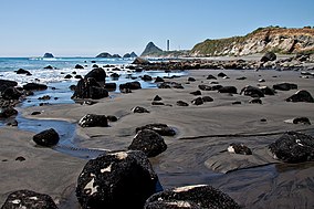
Omata is a locality in Taranaki, in the western North Island of New Zealand. It is located on State Highway 45 just southwest of New Plymouth. Omata and Western New Plymouth are adjacent to the Tapuae Marine Reserve.

Ōakura is a small township in New Plymouth District, Taranaki, in the western North Island of New Zealand. It is located on State Highway 45, 15 kilometres south-west of New Plymouth. Ōkato is 12 km further south-west. The Oakura River flows past the town and into the North Taranaki Bight. To the south is the Kaitake Range, part of Egmont National Park.

Port Taranaki is a port complex located in New Plymouth, New Zealand. It is the only deep water port on the west coast of New Zealand, and is owned by the Taranaki Regional Council. The port handles a wide range of coastal and international cargoes, mostly relating to the farming, engineering and petrochemical industries.

The Sugar Loaf Islands are a collection of five small uninhabited islands and several sea stacks near Port Taranaki, New Zealand.

Lovers Point State Marine Reserve (SMR) is one of four small marine protected areas located near the cities of Monterey and Pacific Grove, at the southern end of Monterey Bay on California’s central coast. The four MPAs together encompass 2.96 square miles (7.7 km2). The SMR protects all marine life within its boundaries. Fishing and take of all living marine resources is prohibited.
Kapiti Marine Reserve is a protected area on two sides of Kapiti Island, off the southern west coast of the North Island of New Zealand. It was created in 1992.
Campus Point State Marine Conservation Area (SMCA) is a marine protected area that protects the waters along and off the coast of the University of California, Santa Barbara, the student community of Isla Vista, and the University's Coal Oil Point Reserve. The SMCA covers 10.51 square miles, including Goleta Point. The marine protected areas protect natural habitats and marine life by prohibiting or limiting removal of wildlife from within their boundaries.

Hikurangi Marine Reserve is a marine reserve off the coast of the Kaikōura District, in the Canterbury Region of New Zealand's South Island. It is the largest and deepest marine reserve in New Zealand.

Kahurangi Marine Reserve is a marine reserve administered by the Department of Conservation, covering 8,419 hectares offshore of Kahurangi National Park in the Buller District of New Zealand's West Coast Region.

Parininihi Marine Reserve is a marine reserve administered by the Department of Conservation, covering 1,800 hectares in the North Taranaki Bight. It is located offshore of the west coast of New Zealand's North Island, north-east of New Plymouth.

Punakaiki Marine Reserve is a marine reserve administered by the Department of Conservation. The reserve includes the area of sea surrounding the pancake rocks and blowholes at Dolomite Point, at Punakaiki on the West Coast Region of New Zealand's South Island. It also includes most of the coastline on the western edge of Paparoa National Park.
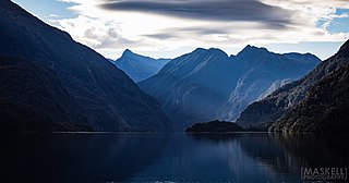
Moana Uta Marine Reserve is a marine reserve covering the entire length of Wet Jacket Arm in Fiordland on New Zealand's South Island, an area of 2,007 hectares. It was established in 2005 and is administered by the Department of Conservation.
Te Hapua Marine Reserve is a marine reserve covering an area of 449 hectares of Te Hāpua / Sutherland Sound, in Fiordland on New Zealand's South Island. It was established in 2005 and is administered by the Department of Conservation.