
Great Barrier Island lies in the outer Hauraki Gulf, New Zealand, 100 kilometres (62 mi) north-east of central Auckland. With an area of 285 square kilometres (110 sq mi) it is the sixth-largest island of New Zealand and fourth-largest in the main chain. Its highest point, Mount Hobson, is 627 metres (2,057 ft) above sea level. The local authority is the Auckland Council.

Waiheke Island is the second-largest island in the Hauraki Gulf of New Zealand. Its ferry terminal in Matiatia Bay at the western end is 21.5 km (13.4 mi) from the central-city terminal in Auckland.

Tiritiri Matangi Island is located in the Hauraki Gulf of New Zealand, 3.4 km (2.1 mi) east of the Whangaparāoa Peninsula in the North Island and 30 km (19 mi) north east of Auckland. The 2.2 km2 (1 sq mi) island is an open nature reserve managed by the Supporters of Tiritiri Matangi Incorporated, under the supervision of the Department of Conservation and is noted for its bird life, including takahē, North Island kōkako and kiwi. It attracts between 30,000 and 32,000 visitors a year, the latter figure being the maximum allowed by the Auckland Conservation Management Strategy.

The Hauraki Gulf / Tīkapa Moana is a coastal feature of the North Island of New Zealand. It has an area of 4000 km2, and lies between, in anticlockwise order, the Auckland Region, the Hauraki Plains, the Coromandel Peninsula, and Great Barrier Island. Most of the gulf is part of the Hauraki Gulf Marine Park.

Moturoa / Rabbit Island is a small island that lies across the southernmost part of Tasman Bay / Te Tai-o-Aorere, on the northern coast of New Zealand's South Island. The long narrow island runs east–west for 8 kilometres (5 mi), and covers 15 km2 (5.8 sq mi).

The Colville Channel is one of three channels connecting the Hauraki Gulf / Tīkapa Moana with the Pacific Ocean to the northeast of Auckland, New Zealand. It is the easternmost channel, lying between the southern end of Great Barrier Island and Cape Colville at the northern tip of the Coromandel Peninsula. The tiny Channel Island lies in the centre of the channel.
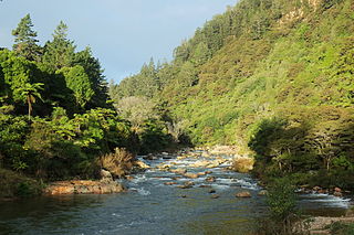
The Ohinemuri River is located in the northern half of New Zealand's North Island, at the base of the Coromandel Peninsula.

The Jellicoe Channel is one of three channels connecting the Hauraki Gulf with the Pacific Ocean to the northeast of Auckland, New Zealand. It is the westernmost channel, lying between Cape Rodney on the North Auckland Peninsula and Little Barrier Island.

Little Barrier Island, or Hauturu in Māori, lies off the northeastern coast of New Zealand's North Island. Located 80 kilometres (50 mi) to the north of Auckland, the island is separated from the mainland to the west by Jellicoe Channel, and from the larger Great Barrier Island to the east by Cradock Channel. The two aptly named islands shelter the Hauraki Gulf from many of the storms of the Pacific Ocean.
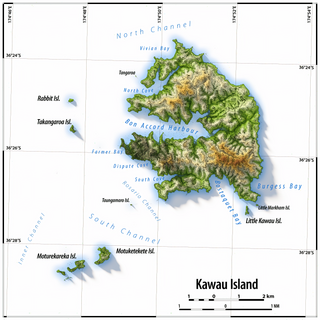
Kawau Island is in the Hauraki Gulf, close to the north-eastern coast of the North Island of New Zealand. At its closest point it lies 1.4 km (0.87 mi) off the coast of the Northland Peninsula, just south of Tāwharanui Peninsula, and about 8 km (5.0 mi) by sea journey from Sandspit Wharf, and shelters Kawau Bay to the north-east of Warkworth. It is 40 km (25 mi) north of Auckland. Mansion House in the Kawau Island Historic Reserve is an important historic tourist attraction. Almost every property on the Island relies on direct access to the sea. There are only two short roads serving settlements at Schoolhouse Bay and South Cove, and most residents have private wharves for access to their front door steps.

Stony Batter is a historic defence installation at the north-eastern end of Waiheke Island, Auckland, New Zealand. It is sited within a 50-acre scenic reserve of the same name, owned by the New Zealand Department of Conservation (DOC). The park serves double duty as a historical and nature reserve, containing unusual rock formations, associated with an extinct volcano, three significant bush blocks and three concrete gun emplacements with an extensive tunnel system, reputed to be the largest in New Zealand.

North Head is a volcano and Tūpuna Maunga forming a headland at the east end of the Waitematā Harbour in Auckland, New Zealand, in the suburb of Devonport. Known for its sweeping views over the harbour and the Hauraki Gulf, since 1885 the head was mainly used by the military as a coastal defence installation, which left a network of accessible old bunkers and tunnels as its legacy, forming part of the attraction. The site was protected as part of Hauraki Gulf Maritime Park in 1972 and listed as a Category I historic place in 2001. As part of a 2014 Treaty of Waitangi claim settlement the volcanic cone was officially named Maungauika and the reserve unofficially renamed Maungauika / North Head Historic Reserve.
The Mokohinau Islands (Pokohinau), sometimes spelt Mokohīnau Islands are a small group of islands that lie off the northeast coast of New Zealand's North Island. The islands are 100 km (62 mi) northeast of Auckland, 21 km (13 mi) northwest of Great Barrier Island and approximately 52 km (32 mi) east of Bream Head. The main islands of the group include Fanal Island (Motukino), Burgess Island (Pokohinu), Flax Island (Hokoromea), and Atihau Island. Smaller islands include Bird Rock. Most of them are managed by the Department of Conservation as nature reserves and wildlife sanctuaries. Landing is not allowed without a permit, with the exception of Burgess Island, much of which is managed as a scenic reserve by the Department of Conservation. The remainder of Burgess Island is Crown Land and is administered by the Ministry of Transport. The total land area of the Mokohinau Islands is 160 ha (400 acres).

Moturekareka Island is a small island off the southern edge of Kawau Island in Auckland's Hauraki Gulf, approximately 43.7 km north of Auckland. It is separated from nearby Motuketekete Island by Blanche Channel.

Mansion House on Kawau Island, New Zealand, is a house that was owned by Sir George Grey from 1862 to 1888. Built in 1845 as the house for the manager of a copper mine on the island, it was extended significantly by Grey during his ownership. Mansion House is a heritage listed building. It is open to the public as part of the Kawau Island Historic Reserve administered by the Department of Conservation.
Pakihi Island is a privately-owned island located in the Hauraki Gulf to the east of the city of Auckland, New Zealand. With an area of 114 hectares, it is one of the smallest of the Hauraki Gulf Islands. It is located 1 km southwest of Ponui Island, and 1.5 km offshore from Waitawa Regional Park.
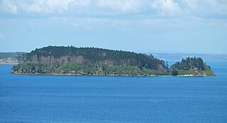
Motuketekete Island is an uninhabited island in the northern Hauraki Gulf, off the northeastern coast of New Zealand's North Island. It is separated from Moturekareka Island to the west by the Blanche Channel.
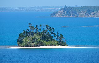
Beehive Island / Taungamaro Island is an island in the Hauraki Gulf of New Zealand. It sits southwest of Kawau Island.

Te Haupa Island, also known as Saddle Island, is an uninhabited island located in the Hauraki Gulf near the mouth of Mahurangi Harbour, Auckland Region, New Zealand. Named after Ngāti Pāoa chief Te Haupa, the island was traditionally used as a seasonal base for shark fishing. The island first became a reserve in 1951.

Challenger Island / Little Kawau Island is an island in the Hauraki Gulf of New Zealand. It sits south of Kawau Island.

