Related Research Articles

The Manukau Harbour is the second largest natural harbour in New Zealand by area. It is located to the southwest of the Auckland isthmus, and opens out into the Tasman Sea.
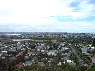
The North Shore is a part of the urban area of Auckland, New Zealand, located to the north of the Waitematā Harbour. From 1989 until 2010, North Shore City was an independent city within the Auckland Region.

The Los Angeles Basin is a sedimentary basin located in southern California, in a region known as the Peninsular Ranges. The basin is also connected to an anomalous group of east-west trending chains of mountains collectively known as the California Transverse Ranges. The present basin is a coastal lowland area, whose floor is marked by elongate low ridges and groups of hills that is located on the edge of the Pacific Plate. The Los Angeles Basin, along with the Santa Barbara Channel, the Ventura Basin, the San Fernando Valley, and the San Gabriel Basin, lies within the greater southern California region. On the north, northeast, and east, the lowland basin is bound by the Santa Monica Mountains and Puente, Elysian, and Repetto hills. To the southeast, the basin is bordered by the Santa Ana Mountains and the San Joaquin Hills. The western boundary of the basin is marked by the Continental Borderland and is part of the onshore portion. The California borderland is characterized by northwest trending offshore ridges and basins. The Los Angeles Basin is notable for its great structural relief and complexity in relation to its geologic youth and small size for its prolific oil production. Yerkes et al. identify five major stages of the basin's evolution, which began in the Upper Cretaceous and ended in the Pleistocene. This basin can be classified as an irregular pull-apart basin accompanied by rotational tectonics during the post-early Miocene.

The Waitākere Ranges is a mountain range in New Zealand. Located between metropolitan Auckland and the west coast of the former Waitakere City and Rodney District, the ranges and its foothills and coasts comprise some 27,720 hectares of public and private land. The area, traditionally known to Māori as Te Wao Nui o Tiriwa, is of local, regional, and national significance. The Waitākere Ranges includes a chain of hills in the Auckland Region, generally running approximately 25 kilometres (16 mi) from north to south, 25 km west of central Auckland. The ranges are part of the Waitākere Ranges Regional Park.
Waitematā Harbour is the main access by sea to Auckland, New Zealand. For this reason it is often referred to as Auckland Harbour, despite the fact that it is one of two harbours adjoining the city. The harbour forms the northern and eastern coasts of the Auckland isthmus and is crossed by the Auckland Harbour Bridge. It is matched on the southern side of the city by the shallower waters of the Manukau Harbour.

The Whau River is an estuarial arm of the southwestern Waitemata Harbour within the Auckland metropolitan area in New Zealand. It flows north for 5.7 kilometres (3.5 mi) from its origin at the confluence of the Avondale Stream and Whau Stream to its mouth between the Te Atatū peninsula and the long, thin Rosebank Peninsula in Avondale. It is 800 metres (2,600 ft) at its widest and 400 metres (1,300 ft) wide at its mouth.
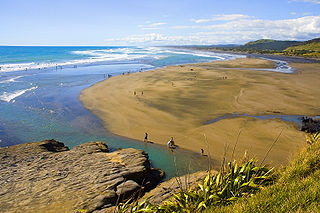
Muriwai, also called Muriwai Beach, is a coastal community on the west coast of the Auckland Region in the North Island of New Zealand. The black-sand surf beach and surrounding area is a popular recreational area for Aucklanders. Gannets nest there in a large colony on the rocks.

The Hibiscus Coast is a stretch of the Hauraki Gulf coast located in New Zealand's Auckland Region. It is the 10th largest urban area in New Zealand, and the second largest in the Auckland Region behind Auckland itself.
Leigh is a small coastal community in the north of the Auckland Region of New Zealand. It lies on the west side of Omaha Cove, a small inlet within Omaha Bay to the south of Cape Rodney. It is 13 km from Matakana, 21 km from Warkworth and approximately 92 km north of Auckland City.

The Panmure Basin, also sometimes known as the Panmure Lagoon, is a tidal estuary within a volcanic crater or maar in New Zealand's Auckland volcanic field. It is located to the south of Panmure town centre.

Meola Reef, or Te Tokaroa in Māori, is a lava flow forming a reef peninsula across part of Auckland's Waitemata Harbour, New Zealand. The reef extends for over 2 kilometres across the harbour, to within 500 metres of Kauri Point on the northern shore.
Achilles Point is a rocky point on the headland at the eastern end of the small sandy beach named Ladies Bay, Auckland, New Zealand. The name 'Te Pane o Horoiwi' can also sometimes refer to the whole headland between St Heliers and Tamaki River estuary. Achilles Point is named after a ship called HMNZS Achilles (70) which defeated the German pocket battleship Admiral Graf Spee in 1939. The headland, from the point round to the Tamaki heads, was previously known as Te Pane o Horoiwi, named after Horoiwi who arrived in New Zealand on the Tainui canoe (waka).

The geology of New Zealand is noted for its volcanic activity, earthquakes and geothermal areas because of its position on the boundary of the Australian Plate and Pacific Plates. New Zealand is part of Zealandia, a microcontinent nearly half the size of Australia that broke away from the Gondwanan supercontinent about 83 million years ago. New Zealand's early separation from other landmasses and subsequent evolution have created a unique fossil record and modern ecology.
The Auckland Region of New Zealand is built on a basement of greywacke rocks that form many of the islands in the Hauraki Gulf, the Hunua Ranges, and land south of Port Waikato. The Waitākere Ranges in the west are the remains of a large andesitic volcano, and Great Barrier Island was formed by the northern end of the Coromandel Volcanic Zone. The main isthmus and North Shore are composed of Waitemata sandstone and mudstone, and portions of the Northland Allochthon extend as far south as Albany. Little Barrier Island was formed by a relatively isolated andesitic volcano, active around 1 to 3 million years ago.
The Waikato and King Country regions of New Zealand are built upon a basement of greywacke rocks, which form many of the hills. Much of the land to the west of the Waikato River and in the King Country to the south has been covered by limestone and sandstone, forming bluffs and a karst landscape. The volcanic cones of Karioi and Pirongia dominate the landscape near Raglan and Kawhia Harbours. To the east, the land has been covered with ignimbrite deposits from the Taupo Volcanic Zone. Large amounts of pumice from the Taupo Volcanic Zone have been deposited in the Waikato Basin and Hauraki Plains.

New Zealand's Northland Region is built upon a basement consisting mainly of greywacke rocks, which are exposed on the eastern side of the peninsula. In-place Eocene coal measures crop out at Kamo, near Whangarei, and Oligocene limestone crops out at Hikurangi, near Whangarei.

The Leigh Marine Laboratory is the marine research facility for the University of Auckland in New Zealand. The laboratory is situated in north eastern New Zealand, 100 kilometres (62 mi) north of Auckland city. The facility is perched on the cliffs overlooking the Cape Rodney-Okakari Point Marine Reserve that covers 5 kilometres (3.1 mi) of coastline from Cape Rodney to Okakari Point. The laboratory provides the facilities to support a wide range of field based research, including overnight field trips for undergraduate students and for postgraduate students to live on campus. The laboratory has a fleet of small boats, including a 15 metres (49 ft) long research vessel, Hawere.
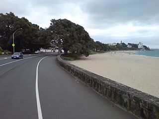
Tamaki Drive is the coastal road which follows the contours of the Waitemata Harbour, Auckland, New Zealand. The road links the suburbs Orakei, Mission Bay, and Kohimarama ending in Saint Heliers providing easy access to the local beaches. Tamaki Drive was completed in 1932 and incorporates The Strand, Bice Esplanade and, what was once part of the old Kohimarama Road. It is also referred to as the Waterfront Road. Tamaki Drive is a flat road around 8 km long and popular with walkers, runners and roller skaters, and includes a dedicated cycle lane. Those travelling along Tamaki Drive can find scenic highlights and peaceful views across the harbour to the volcanic island Rangitoto. The cliffs backing onto Tamaki Drive are made of Waitemata Sandstone strata clothed in places with pohutukawa. These trees seem to flower out of season, because these are actually Kermadec pohutukawa with small distinctive roundish leaves.

The Nias Basin is a forearc basin located off the western coast of Sumatra, Indonesia, in the Indian Ocean. The name is derived from the island that bounds its western edge, the island of Nias. The Nias Basin, the island of Nias, and the offshore, submarine accretionary complex, together form a Forearc region on the Sunda Plate/Indo-Australian Plate collisional/subduction boundary. The Forearc region is the area between an oceanic trench and its associated volcanic arc. The oceanic trench associated with the Nias Basin is the Sunda Trench, and the associated volcanic arc is the Sunda Arc.

The Waitemata Group is an Early Miocene geologic group that is exposed in and around the Auckland Region of New Zealand, between the Whangarei Harbour in the North and the Raglan Harbour in the South. The Group is predominantly composed of deep water sandstone and mudstone (flysch). The sandstone dominated units form the cliffs around the Waitemata Harbour and rare more resistant conglomerates underlie some of Auckland's prominent ridges.
References
- ↑ "Notice of New and Altered Geographic Names, and Altered Crown Protected Area Names, for Ngāti Manuhiri Treaty of Waitangi Settlement 2012". Land Information New Zealand. 20 December 2012. Archived from the original on 12 February 2013. Retrieved 16 March 2013.
- ↑ "Islands and bays renamed in Maori". stuff.co.nz. 7 June 2011. Retrieved 16 March 2013.
- ↑ "Place name detail: Mathesons Bay". New Zealand Gazetteer. New Zealand Geographic Board . Retrieved 16 March 2013.
- ↑ RICKETTS, B.D., BALANCE, P.F., HAYWARD, B.W. and MAYER, W., 1989, Basal Waitemata Group lithofacies: rapid subsidence in an early Miocene interarc basin, New Zealand: Sedimentology, v. 36 (4), p. 559 - 580.
- ↑ EAGLE, M.K., HAYWARD, B.W., GRANT-MACKIE, J.A. and GREGORY, M. R., 1999, Fossil communities in an Early Miocene transgressive sequence, Mathesons Bay, Leigh, Auckland: Tane, v. 37, p. 43–67.
- ↑ CRAMPTON, J.S., TEREZOW, M.G. 2018 The Kiwi fossil hunter's handbook. Auckland: Random House. 207 p.
Coordinates: 36°18′17″S174°47′52″E / 36.3048°S 174.7977°E
| | This Auckland Region-related geography article is a stub. You can help Wikipedia by expanding it. |