
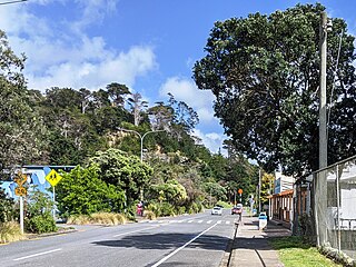
Warkworth is a town on the Northland Peninsula in the upper North Island of New Zealand. It is in the northern part of the Auckland Region, 64 km (40 mi) north of Auckland and 98 km (61 mi) south of Whangārei, at the head of Mahurangi Harbour. State Highway 1 runs past it.

Orewa is a settlement in the northern Auckland Region of New Zealand. It is a suburb of the Hibiscus Coast, just north of the base of the Whangaparāoa Peninsula and 40 kilometres (25 mi) north of central Auckland. The Northern Motorway, part of State Highway 1, passes just inland of Orewa and extends through the twin Johnston Hill tunnels to near Puhoi.
The Hibiscus Coast is a populated area on a stretch of the Hauraki Gulf coast in New Zealand's Auckland Region. It has a population of 69,070, making it the 10th most populous urban area in New Zealand, and the second most populous in the Auckland Region, behind Auckland itself. As an urban area delineated by Statistics New Zealand, the Hibiscus Coast consists of Hatfields Beach, Orewa, Silverdale and Whangaparāoa Peninsula. The Auckland Council's Hibiscus Coast subdivision of the Hibiscus and Bays includes the neighbouring communities of Waiwera and Stillwater, and Milldale in Rodney, is also described as a part of the Hibiscus Coast.

Rothesay Bay is a small suburb in Auckland's East Coast Bays region. The suburb is roughly the same size as Murrays Bay, the suburb to the immediate south.

Snells Beach is a small coastal town in the north of Auckland Region in the North Island of New Zealand. It is situated on the eastern coast of the Mahurangi Peninsula and its namesake beach faces east across Kawau Bay to Kawau Island. The nearest town is Warkworth, 8 km (5.0 mi) to the west, which is linked by 8 buses a day and also Mahu City Express twice a day.

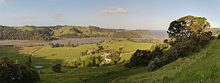
The Wairoa River, also known as Wairoa South, is the second longest river in the Auckland Region of New Zealand's North Island. It flows south from its sources in the Hunua Ranges, then northwards into the Hauraki Gulf. The Wairoa Reservoir and Hūnua Falls form sections of the river, and the Wairoa River flows adjacent to the township of Clevedon.
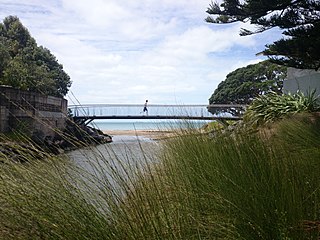
Waiwera is a small town in the north of the Auckland Region in New Zealand. Waiwera is 6 km north of Orewa, 6 km south-east of Puhoi, 23 km south-east of Warkworth and approximately 35 km from the Auckland City centre. The settlement lies at the outlet of a river also called Waiwera. Less than 1 kilometre north of the Waiwera turn-off lies the turn-off to Wenderholm Regional Park which is situated on the far side of the headland to the north of the Waiwera River outlet.
Campbells Bay is a suburb of the North Shore located in Auckland, New Zealand.

The Ōrewa River is a river of the Auckland Region of New Zealand's North Island. It flows east to reach Whangaparāoa Bay just to the north of Whangaparaoa Peninsula. The town of Orewa is near the river's mouth.
The Puhoi River is a river of the Auckland Region of New Zealand's North Island. It flows southeast from its sources 10 kilometres (6 mi) southwest of Warkworth, passing through the town of Puhoi before reaching the coast of Whangaparaoa Bay seven kilometres north of Orewa.
Wenderholm Regional Park is a regional park north of Auckland in New Zealand's North Island. It is situated between the estuaries of the Puhoi River and the Waiwera River, on the east coast of New Zealand's North Island and features a homestead known as Couldrey House, and a carved pouwhenua.

Scandrett Regional Park is a regional park located on the north east tip of the Mahurangi Peninsula, north of the city of Auckland, New Zealand. It encompasses Mullet Point and includes regenerating coastal forest, rocky headlands that protrude into Kawau Bay, Scandretts Bay beach and a precinct of historic farm buildings. The people of Auckland own the park through the Auckland Council.

Waiake is one of the northernmost suburbs of the North Shore, in Auckland, New Zealand. It is located in the East Coast Bays between the suburbs of Browns Bay to the south and Torbay to the north. It has a beach, which looks out to the Tor, a presque-isle at the north end of the beach that becomes an island at high tide. Waiake is under the local governance of the Auckland Council.

Baddeleys Beach and Campbells Beach are a contiguous settlement on adjacent beaches on the southern side of Tāwharanui Peninsula in the Auckland Region of New Zealand. The beaches are on Millon Bay, which is a part of Kawau Bay.
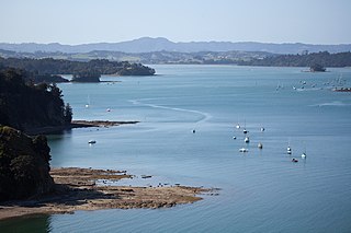
Mahurangi Harbour is a natural harbour in New Zealand. It is located on the north-eastern coast of the Auckland Region near the town of Warkworth, and empties into the Hauraki Gulf.

The Whangateau Harbour is a natural harbour in New Zealand. It is a sandspit estuary, located on the north-eastern coast of the Auckland Region north-east of Matakana, and empties into the Hauraki Gulf. Due to the harbour's high quality water and dense shellfish beds, the harbour is a popular spot for shellfish gathering.
Mahurangi Island, is an island at the mouth of the Waiwera River, in the Auckland Region, New Zealand.

Lucas Creek is a stream and tidal estuary of Upper Waitematā Harbour in the Auckland Region of New Zealand's North Island. It flows through Albany on the western North Shore, and enters the Upper Waitematā Harbour between Pāremoremo and Greenhithe.

Te Muri Regional Park is a regional park north of Auckland in New Zealand's North Island. It is situated between the estuaries of the Puhoi River and Te Muri-O-Tarariki Stream, on the east coast of New Zealand's North Island. The park is bordered by two other regional parks: Mahurangi West Regional Park to the north, and Wenderholm Regional Park to the south.

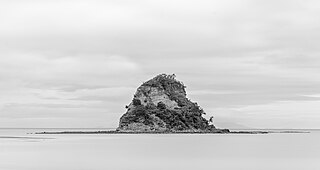
Te Haupa Island, also known as Saddle Island, is an uninhabited island located in the Hauraki Gulf near the mouth of Mahurangi Harbour, Auckland Region, New Zealand. Named after Ngāti Pāoa chief Te Haupa, the island was traditionally used as a seasonal base for shark fishing. The island first became a reserve in 1951.


