
Whangārei is the northernmost city in New Zealand and the regional capital of Northland Region. It is part of the Whangārei District, a local body created in 1989 from the former Whangārei City, Whangārei County and Hikurangi Town councils, to administer both the city proper and its hinterland. The city population was estimated to be 54,900 in June 2022, an increase from 47,000 in 2001. The wider Whangarei District had a population of 100,500 in June 2022,

Mount Wellington is a suburb in East Auckland, New Zealand, located 10 kilometres southeast of the city centre. It is surrounded by the suburbs of Stonefields, Tamaki, Panmure, Penrose, and Ellerslie, and by the Tamaki River. The suburb is named after the volcanic peak of Maungarei / Mount Wellington. Sylvia Park is a large business park and shopping centre located in the suburb.
The Waitākere Ranges is a mountain range in New Zealand. Located in West Auckland between metropolitan Auckland and the Tasman Sea, the ranges and its foothills and coasts comprise some 27,720 hectares of public and private land. The area, traditionally known to Māori as Te Wao Nui o Tiriwa, is of local, regional, and national significance. The Waitākere Ranges includes a chain of hills in the Auckland Region, generally running approximately 25 kilometres (16 mi) from north to south, 25 km west of central Auckland. The ranges are part of the Waitākere Ranges Regional Park.

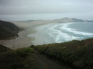
Karekare is a small coastal settlement in West Auckland, New Zealand, sandwiched between the Waitākere Ranges and a large black sand surf beach.

Mount Auckland officially known as Atuanui / Mount Auckland is a hill in the northern Auckland region, near the shore of the Kaipara Harbour.
In Māori tradition, Moekākara was one of the great ocean-going, voyaging canoes that was used in the migrations that settled New Zealand. It was captained by Tāhuhunui-o-te-rangi, the ancestor of Ngāi Tāhuhu. The canoe first landed at Wakatuwhenua, near Te Arai north of Auckland. Ngāi Tāhuhu settled at Pouerua in the Bay of Islands and the Mangakahia River in Northland, as well as Ōtāhuhu in Auckland.

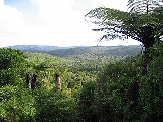
The Northland temperate kauri forests is an ecoregion in northern New Zealand, within the temperate broadleaf and mixed forests biome.
Muriwhenua are a group of northern Māori iwi, based in Te Hiku o te Ika, the northernmost part of New Zealand's North Island. It consists of six iwi, Ngāti Kurī, Ngāi Takoto, Te Pātū, Ngāti Kahu, Te Aupōuri and Te Rarawa, with a combined population of about 34,000 people. The spiritually significant Hokianga Harbour, located just to the south of the Maungataniwha Range, is of special significance to the Muriwhenua people.
Maungarei is a 135-metre volcanic peak and Tūpuna Maunga located in the Auckland volcanic field of Auckland, New Zealand. It is the youngest onshore volcano of the Auckland volcanic field, having been formed by an eruption around 10,000 years ago. It is the largest of Auckland's scoria cones and has a near-circular base with a flattish rim and three small craters. It is situated in the Mount Wellington suburb of East Auckland.

Te Toiokawharu is a hill in the Waitākere Ranges of the Auckland Region of New Zealand's North Island. At 474-metres, it is the tallest peak of the Waitākere Ranges. The peak has a low prominence due to surrounding hills of similar sizes.
Reitū and Reipae were twin sisters from the Tainui confederation of Māori tribes in Waikato, New Zealand, who lived before European settlement. Tainui tradition remembers them for the story of Reitū's courtship by Ue-oneone and for the important genealogical connection between Tainui and Ngā Puhi that was created by their marriages.

The Waikumete Stream is a stream of the Auckland Region of New Zealand's North Island. It flows north from its sources in Titirangi, before joining the Oratia Stream. Both bodies are tributaries of Te Wai-o-Pareira / Henderson Creek, which flows into the western Waitematā Harbour. The stream passes through the suburbs of Titirangi, Kaurilands, Glen Eden and Sunnyvale, and since the mid-2000s has been forested with native flora.

The Oratia Stream is a stream of the Auckland Region of New Zealand's North Island. It flows north-east from its source at the township of Waiatarua in the Waitākere Ranges, before entering into the Te Wai-o-Pareira / Henderson Creek, which flows into the western the Waitematā Harbour. After beginning at Waiatarua, the stream passes through the rural locality of Oratia and the West Auckland suburbs of Sunnyvale and Henderson. Since the mid-2000s has been forested with native flora.
The Opanuku Stream, formerly known as the Henderson Stream, is a stream of the Auckland Region of New Zealand's North Island. It flows east from its source the Waitākere Ranges through the Henderson Valley, then north-east through West Auckland before entering into the Te Wai-o-Pareira / Henderson Creek, which flows into the western the Waitematā Harbour. The stream passes through the rural locality of Henderson Valley and the West Auckland suburbs of Western Heights and Henderson. Since the mid-2000s has been forested with native flora.

The Swanson Stream is a stream of the Auckland Region of New Zealand's North Island. It flows north-east from its source the Waitākere Ranges through rural West Auckland towards the suburb of Swanson, before joining the Momutu Stream, which exits into Te Wai-o-Pareira / Henderson Creek and the western the Waitematā Harbour. Since the mid-2000s has been forested with native flora.

The Kakamatua Inlet is an inlet of the Manukau Harbour of the Auckland Region of New Zealand's North Island.

Pukematekeo is a hill in the Waitākere Ranges of the Auckland Region of New Zealand's North Island. It is located west of Henderson, and is the northernmost hill in the Waitākere Ranges Regional Park.

Ruaotuwhenua is a hill in the Waitākere Ranges of the Auckland Region of New Zealand's North Island. At 440-metres, it is one of the tallest of the Waitākere Ranges, and the tallest of the eastern ranges adjacent to Auckland. The peak is the location of an air traffic radome, and a radio mast is located further down the slope of the hill in Waiatarua.

The Goldie Bush Scenic Reserve, also known as Goldies Bush and Te Taiapa, is a forested area of West Auckland, New Zealand. Located south-east of Muriwai, the reserve is home to the Mokoroa Falls.

Motueka Island, also known by the name Pigeon Island, is an island off the coast of the Coromandel Peninsula in New Zealand.

