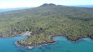
Rangitoto Island is a volcanic island in the Hauraki Gulf near Auckland, New Zealand. The 5.5 km (3.4 mi) wide island is a symmetrical shield volcano cone capped by central scoria cones, reaching a height of 260 m (850 ft). Rangitoto is the youngest and largest of the approximately 50 volcanoes of the Auckland volcanic field, having erupted in two phases about 620 and 600 years ago and covering an area of 2,311 ha. It is separated from the mainland of Auckland's North Shore by the Rangitoto Channel. Since World War II, it has been linked by a causeway to the much older, non-volcanic Motutapu Island.

The Manukau Harbour is the second largest natural harbour in New Zealand by area. It is located to the southwest of the Auckland isthmus, and opens out into the Tasman Sea.
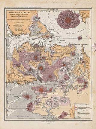
The Auckland volcanic field is an area of monogenetic volcanoes covered by much of the metropolitan area of Auckland, New Zealand's largest city, located in the North Island. The approximately 53 volcanoes in the field have produced a diverse array of maars, tuff rings, scoria cones, and lava flows. With the exception of Rangitoto, no volcano has erupted more than once, but the other eruptions lasted for various periods ranging from a few weeks to several years. Rangitoto erupted several times and recently twice; in an eruption that occurred about 600 years ago, followed by a second eruption approximately 50 years later. The field is fuelled entirely by basaltic magma, unlike the explosive subduction-driven volcanism in the central North Island, such as at Mount Ruapehu and Lake Taupō. The field is currently dormant, but could become active again.

Waitematā Harbour is the main access by sea to Auckland, New Zealand. For this reason it is often referred to as Auckland Harbour, despite the fact that it is one of two harbours adjoining the city. The harbour forms the northern and eastern coasts of the Auckland isthmus and is crossed by the Auckland Harbour Bridge. It is matched on the southern side of the city by the shallower waters of the Manukau Harbour.

The Northland Peninsula, called the North Auckland Peninsula in earlier times, is in the far north of the North Island of New Zealand. It is joined to the rest of the island by the Auckland isthmus, a narrow piece of land between the Waitematā Harbour and the Manukau Harbour in the middle of the Auckland metropolitan area. The peninsula is not conterminous with the local government area of Northland Region, which occupies the northern 80% of the peninsula. The southern section of the peninsula is administratively part of the Auckland Region.

Muriwai, also called Muriwai Beach, is a coastal community on the west coast of the Auckland Region in the North Island of New Zealand. The black-sand surf beach and surrounding area is a popular recreational area for Aucklanders. The Muriwai Regional Park includes a nesting site for a large colony of gannets.

Motukorea or Browns Island is a small New Zealand island, in the Hauraki Gulf north of Musick Point, one of the best preserved volcanoes in the Auckland volcanic field. The age of eruption is about 25,000 years ago, when the Tāmaki Estuary and the Waitemata Harbour were forested river valleys. Due to centuries of cultivation, little native bush remains except on the north-eastern cliffs, leaving the volcanic landforms easily visible. It exhibits the landforms from three styles of eruption. The island consists of one main scoria cone with a deep crater, a small remnant arc of the tuff ring forming the cliffs in the northeast, and the upper portions of lava flows. The area was dry land when the eruptions occurred, but much of the lava is now submerged beneath the sea.

Meola Reef, or Te Tokaroa in Māori, is a lava flow forming a reef peninsula across part of Auckland's Waitemata Harbour, New Zealand. The reef extends for over 2 kilometres across the harbour, to within 500 metres of Kauri Point on the northern shore.

Achilles Point is a rocky point on the headland at the eastern end of the small sandy beach named Ladies Bay, Auckland, New Zealand. The name 'Te Pane o Horoiwi' can also sometimes refer to the whole headland between St Heliers and Tamaki River estuary. Achilles Point is named after a ship called HMNZS Achilles (70) which defeated the German pocket battleship Admiral Graf Spee in 1939. The headland, from the point round to the Tamaki heads, was previously known as Te Pane o Horoiwi, named after Horoiwi who arrived in New Zealand on the Tainui canoe (waka).

The geology of New Zealand is noted for its volcanic activity, earthquakes and geothermal areas because of its position on the boundary of the Australian Plate and Pacific Plates. New Zealand is part of Zealandia, a microcontinent nearly half the size of Australia that broke away from the Gondwanan supercontinent about 83 million years ago. New Zealand's early separation from other landmasses and subsequent evolution have created a unique fossil record and modern ecology.
The Auckland Region of New Zealand is built on a basement of greywacke rocks that form many of the islands in the Hauraki Gulf, the Hunua Ranges, and land south of Port Waikato. The Waitākere Ranges in the west are the remains of a large andesitic volcano, and Great Barrier Island was formed by the northern end of the Coromandel Volcanic Zone. The Auckland isthmus and North Shore are composed of Waitemata sandstone and mudstone, and portions of the Northland Allochthon extend as far south as Albany. Little Barrier Island was formed by a relatively isolated andesitic volcano, active around 1 to 3 million years ago.
The Waikato and King Country regions of New Zealand are built upon a basement of greywacke rocks, which form many of the hills. Much of the land to the west of the Waikato River and in the King Country to the south has been covered by limestone and sandstone, forming bluffs and a karst landscape. The volcanic cones of Karioi and Pirongia dominate the landscape near Raglan and Kawhia Harbours. To the east, the land has been covered with ignimbrite deposits from the Taupo Volcanic Zone. Large amounts of pumice from the Taupo Volcanic Zone have been deposited in the Waikato Basin and Hauraki Plains.

Cape Rodney-Okakari Point Marine Reserve is a 5.5 km2 (2.1 sq mi) protected area in the North Island of New Zealand.
New Zealand's Northland Region is built upon a basement consisting mainly of greywacke rocks, which are exposed on the eastern side of the peninsula. In-place Eocene coal measures crop out at Kamo, near Whangarei, and Oligocene limestone crops out at Hikurangi, near Whangarei.
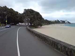
Tamaki Drive is the coastal road which follows the contours of the Waitematā Harbour, Auckland, New Zealand. The road links the suburbs Ōrākei, Mission Bay, and Kohimarama ending in Saint Heliers providing easy access to the local beaches. Tamaki Drive was completed in 1932 and incorporates The Strand, Bice Esplanade and, what was once part of the old Kohimarama Road. It is also referred to as the Waterfront Road. Tamaki Drive is a flat road around 8 km long and popular with walkers, runners and roller skaters, and includes a dedicated cycle lane. Those travelling along Tamaki Drive can find scenic highlights and peaceful views across the harbour to the volcanic island Rangitoto. The cliffs backing onto Tamaki Drive are made of Waitemata Sandstone strata clothed in places with pohutukawa. These trees seem to flower out of season, because these are actually Kermadec pohutukawa with small distinctive roundish leaves.
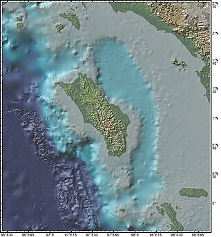
The Nias Basin is a forearc basin located off the western coast of Sumatra, Indonesia, in the Indian Ocean. The name is derived from the island that bounds its western edge, the island of Nias. The Nias Basin, the island of Nias, and the offshore, submarine accretionary complex, together form a Forearc region on the Sunda Plate/Indo-Australian Plate collisional/subduction boundary. The Forearc region is the area between an oceanic trench and its associated volcanic arc. The oceanic trench associated with the Nias Basin is the Sunda Trench, and the associated volcanic arc is the Sunda Arc.

The Waitemata Group is an Early Miocene geologic group that is exposed in and around the Auckland Region of New Zealand, between the Whangarei Harbour in the North and the Raglan Harbour in the South. The Group is predominantly composed of deep water sandstone and mudstone (flysch). The sandstone dominated units form the cliffs around the Waitemata Harbour and rare more resistant conglomerates underlie some of Auckland's prominent ridges.

West Auckland is one of the major geographical areas of Auckland, the largest city in New Zealand. Much of the area is dominated by the Waitākere Ranges, the eastern slopes of the Miocene era Waitākere volcano which was upraised from the ocean floor, and now one of the largest regional parks in New Zealand. The metropolitan area of West Auckland developed between the Waitākere Ranges to the west and the upper reaches of the Waitematā Harbour to the east. It covers areas such as Glen Eden, Henderson, Massey and New Lynn.

O'Neill Bay is a bay on the Auckland Region of New Zealand's North Island. It is located north of Te Henga / Bethells Beach.
The Waitākere volcano, also known as the Manukau volcano, was a Miocene era volcano that formed off the west coast of the modern Auckland Region of New Zealand's North Island. Erupting intermittently between 23 million and 15 million years ago, the volcano was at one point one of the tallest mountains in New Zealand. The volcano alternated between periods as a seamount and as a volcanic island, before tectonic forces raised the volcano up from the seafloor 17 million years ago. Volcanism at the site ceased 15 million years ago and the cone has mostly eroded, however the modern Waitākere Ranges are formed from the remnants of the volcano's eastern slopes. A number of visible volcanic sites associated with the Waitākere volcano remain around Auckland, including Pukematekeo, Karekare and Lion Rock.

