Related Research Articles

Omaha is the largest city in the U.S. state of Nebraska and the county seat of Douglas County. Omaha is in the Midwestern United States on the Missouri River, about 10 miles (15 km) north of the mouth of the Platte River. The nation's 39th-largest city, Omaha's 2020 census population was 486,051. It is the second-largest city in the Great Plains states, the second-largest city along the Missouri River, and the seventh-largest city in the Midwest.

Ray Township is a civil township of Macomb County in the U.S. state of Michigan. As of the 2010 census, the township population was 3,739, which makes Ray Township the least populated township in Macomb County. Wolcott Mill Metropark, a 2,625 acres (10.62 km2) park is located entirely within the township. The park is home to the Wolcott Mill, built in 1847.

Osceola is a village in Polk County, Wisconsin, United States. The population was 2,568 at the 2010 census. Located mostly within the Town of Osceola, the village sits on the border with Minnesota, separated by the St. Croix River. It is along Wisconsin Highway 35.

Makah Reservation is an Indian reservation of the Makah Native Americans located on the northwestern tip of the Olympic Peninsula in Clallam County, Washington, United States. The northern boundary of the reservation is the Strait of Juan de Fuca. The western boundary is the Pacific Ocean. It has a land area of 121.451 square kilometres (46.892 sq mi) and a 2000 census resident population of 1,356 persons. Its largest community is Neah Bay.
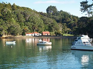
Leigh is a small coastal community in the north of the Auckland Region of New Zealand. It lies on the west side of Omaha Cove, a small inlet within Omaha Bay to the south of Cape Rodney. It is 13 km from Matakana, 21 km from Warkworth and approximately 92 km north of Auckland City.
Whangateau is a small town on the east coast of the North Island of New Zealand. It is situated in Rodney District, part of the Auckland Region, and is on a peninsula stretching out into the Hauraki Gulf, north of Auckland. Whangateau is on the northern shore of Whangateau Harbour which is fed by the Omaha River and separated from Omaha Bay by the Maungatawhiri sandspit. The settlement is in two parts of 20 to 30 houses each. The main settlement includes a large public reserve with sports fields and a campground. There is also a public hall which hosts music events and a flax weaving group. The smaller settlement is Tram Car Bay, named for two tram cars which were used as holiday homes. Whangateau is situated between the rural settlement of Matakana and the fishing village of Leigh. A tsunami siren is located in the town.
Eersteriver Secondary School is an Afrikaans-medium school in Eerste River in the Western Cape, South Africa. It was established in 1995 and as of 2006 it had some 1,443 students and 43 educators. In 2006 the Western Cape Education Department designated it one of 10 "Arts and Culture focus schools" to be set up over the following three years. Eersteriver Secondary school is now being linked to Teddington School

The Mormon Bridge is a bridge composed of two cantilevers that crosses the Missouri River connecting Pottawattamie County, Iowa with the Florence neighborhood of Omaha, Nebraska via Interstate 680 (Iowa-Nebraska). The bridge is officially called the Mormon Pioneer Memorial Bridge due to its location on the historic Mormon Trail, which passed nearby.

Jobbers Canyon Historic District was a large industrial and warehouse area comprising 24 buildings located in downtown Omaha, Nebraska, US. It was roughly bound by Farnam Street on the north, South Eighth Street on the east, Jackson Street on the south, and South Tenth Street on the west. In 1989, all 24 buildings in Jobbers Canyon were demolished, representing the largest National Register historic district loss to date.

Trails in Omaha, Nebraska include 80 miles (130 km) of paved trails as well as unpaved trails and paths for recreational usage throughout the city. Popular among bicyclists, runners, hikers and recreational walkers, these trails are included in comprehensive plans for the city of Omaha, the Omaha metro area, Douglas County, and long-distance coordinated plans between the municipalities of southeast Nebraska.

The Lincoln Highway in Omaha, Nebraska, runs east–west from near North 183rd Street and West Dodge Road in Omaha, Nebraska, towards North 192nd Street outside of Elkhorn. This section of the Lincoln Highway, one of only 20 miles (32 km) that were paved with brick in Nebraska, is one of the most well-preserved in the country. The roadway was listed on the National Register of Historic Places in 1984. The Lincoln Highway was the first road across the United States, traversing coast-to-coast from Times Square in New York City to Lincoln Park in San Francisco, California.

Transportation in Omaha, Nebraska, includes most major modes, such as pedestrian, bicycle, automobile, bus, train and airplane. While early transportation consisted of ferries, stagecoaches, steamboats, street railroads, and railroads, the city's transportation systems have evolved to include the Interstate Highway System, parklike boulevards and a variety of bicycle and pedestrian trails. The historic head of several important emigrant trails and the First Transcontinental Railroad, its center as a national transportation hub earned Omaha the nickname "Gate City of the West" as early as the 1860s.
Palca District is one of ten districts of the province Lampa in Peru.
Wildwood Park for the Arts is a developing botanical garden and center for the arts located in western Little Rock, Arkansas's Chenal Valley. Its mission is to challenge the intellect, engage the imagination and celebrate the human spirit through encounters with nature and a full spectrum of the cultural arts: visual arts, performing, literary, horticulture, culinary and more.
The Omaha River is a river of the Auckland Region of New Zealand's North Island. It flows south to reach the Pacific Ocean at the western end of Whangateau Harbour, 3 kilometres (2 mi) west of Omaha.
Assunção, Paraíba is a municipality in the state of Paraíba in the Northeast Region of Brazil.
Leskova Bara is a village in the municipality of Surdulica, Serbia. According to the 2002 census, the village has a population of 139 people.
The Kırklareli University was founded at 2007 under the administration of the Trakya University Rectorate Enver Duran. The university is based on a strong background of the Faculty of Engineering, built at 1992.
The Homs Sanjak was a prefecture (sanjak) of the Ottoman Empire, located in modern-day Syria. The city of Homs was the Sanjak's capital. It had a population of 200,410 in 1914. The Sanjak of Homs shared same region with Sanjak of Hama and Sanjak of Salamiyah.

Triangle 54 is a 8,973.36-square-foot (833.652 m2) public park located in the Blissville neighborhood of Long Island City in Queens, New York City. This traffic triangle is bound by 48th Street on the southwest and east, and 54th Avenue on the north. The park contains ten trees and a memorial flagstaff in its center that dates to 1930. On its granite base is inscribed, "Erected by the citizens of Laurel Hill in memory of those who died in the World War." Laurel Hill is an old name for this area, which once had its own railroad station. The name still appears on the map in Laurel Hill Boulevard, which runs a few blocks to the north of this site.
References
- ↑ "Big Omaha Trail". Big Omaha Trail. Retrieved 15 September 2021.
Coordinates: 36°19′20″S174°43′51″E / 36.32222°S 174.73083°E
| | This New Zealand–related article is a stub. You can help Wikipedia by expanding it. |