Whangateau Harbour

Last updated

Whangateau Harbour
Whangateau Harbour 2011-06-26.jpg
Location Auckland Region, New Zealand
Coordinates 36°19′34″S174°46′05″E / 36.3261°S 174.7681°E / -36.3261; 174.7681 (Whangateau Harbour)
River sourcesBirdsalls Stream, Coxhead Creek, Ōmaha River, Tamahunga Stream, Waikokopu Creek
Ocean/sea sources Pacific Ocean
Basin  countriesNew Zealand
Max. length6.3 km (3.9 mi)
Max. width1.9 km (1.2 mi)
Surface area750 ha (1,900 acres) [1]
Islands Horseshoe Island
Settlements Big Ōmaha, Ōmaha, Point Wells, Ti Point, Tramcar Bay, Whangateau
Whangateau Harbour
Location and extent of Whangateau Harbour

The Whangateau Harbour is a natural harbour in New Zealand. It is a sandspit estuary, located on the north-eastern coast of the Auckland Region north-east of Matakana, and empties into the Hauraki Gulf. Due to the harbour's high quality water and dense shellfish beds (primarily pipi), the harbour is a popular spot for shellfish gathering.

Contents

Geography

The Whangateau Harbour is a sandspit estuary, separated from Ōmaha Bay by a sandspit, where the town of Ōmaha is located. The modern harbour formed during the Holocene, after the formation of the sandspit. [1] Horseshoe Island is an exposed sand-bar located in the centre of the harbour. [1]

The Whangateau Harbour has almost complete tidal flushing, meaning it has some of the best water quality for a harbour in New Zealand. [1]

Flora and fauna

Many reefs can be found in the Whangateau Harbour Whangateau Harbour reef.jpg
Many reefs can be found in the Whangateau Harbour

The harbour has a wide range of intertidal and subtidal reefs, supporting a wide range of benthic wildlife. High numbers of Scutus breviculus , octopuses and Australasian sea cucumbers live in the estuary. The harbour has dense beds of shellfish, primarily pipi ( Paphies australis ). [1] The Harbour is made up of mangals composed of trees rather than bushes. There are a number of different types of algae, which house isopoda and amphipoda. It is also home to the tunnelling mud crab and different types of oyster. [2]

The harbour is a popular spot to collect shellfish. [1] It has been well-studied, due to the harbour's close location to the Leigh Marine Laboratory. [1] In 2009, the area experienced a mortality event of cockles, with an 84% reduction in the large cockle population from the previous year. [3] A further event took place in 2014, with the beds being closed to harvesting while samples were sent to the Ministry for Primary Industries. [4]

History

The Whangateau Harbour is within the traditional rohe of Ngāti Manuhiri. [5] The name Whāngateau was a traditional Māori language name for the harbour, and refers to the strong tidal currents in the estuary. [5] The harbour and surrounding Mahurangi area was first settled in the 14th century by Māori, descendants of the Moekākara , Tainui , Arawa migratory canoes. By the 16th century, the Tāmaki Māori who settled in the region begun to be known by the name Ngā Oho. [6] The tribal affiliation Ngāti Manuhiri began in the 17th century, and refers to Manuhiri, one of the four sons of the Te Kawerau ā Maki rangatira Maki. [6]

Prior to European settlement, six fortified defended the harbour, and the harbour (especially the Waikokopu to the south) were an important source of pipi and tuangi (cockles). [5] The harbour was associated with the kūaka (bar-tailed godwit), which were traditionally harvested in the summer-time. [5]

Ngāti Manuhiri settled the harbour until the late 19th century, however members of Ngāti Manuhiri have returned to the harbour in modern times. [5] [6] In the 1850s, land around the harbour was purchased by Ranulph Dacre. [7] Between 1942 and 1963, 380,000 cubic metres of sand were mined from the Mangatawhiri Spit, leading to coastal erosion at Omaha. [1] Land use around the harbour intensified in the 1960s, and in the 1970s the Omaha causeway was constructed, creating an east-west bridge between Omaha and Point Wells over the Waikokopu Creek. [1]

Related Research Articles

<span class="mw-page-title-main">Kaipara Harbour</span> Harbour estuary in New Zealand

Kaipara Harbour is a large enclosed harbour estuary complex on the north western side of the North Island of New Zealand. The northern part of the harbour is administered by the Kaipara District and the southern part is administered by the Auckland Council. The local Māori tribe is Ngāti Whātua.

Aotea Harbour is a settlement and smallest of three large natural inlets in the Tasman Sea coast of the Waikato region of New Zealand's North Island. It is located between Raglan Harbour to the north and Kawhia Harbour to the south, 30 kilometres southwest of Hamilton.

<span class="mw-page-title-main">Glenfield, New Zealand</span> Suburb in Auckland, New Zealand

Glenfield is a suburb of Auckland, New Zelaand, located on the North Shore. Established as a rural community in the 1850s, the area developed as a suburban part of Auckland after the completion of the Auckland Harbour Bridge in 1959.

<span class="mw-page-title-main">Browns Bay, New Zealand</span> Suburb in Auckland, New Zealand

Browns Bay is one of the most northernmost suburbs in the contiguous Auckland metropolitan area, located in the North Shore. Named after the Brown family who settled here in 1876, Browns Bay became a holiday destination in the late 19th century. The area gradually developed into a suburb of Auckland in the 1950s, and was the administrative centre for the East Coast Bays City from 1975 until it was disestablished in 1989. During the 1990s, the suburb became a hub for the South African New Zealander community.

<span class="mw-page-title-main">Mairangi Bay</span> Suburb in Auckland, New Zealand

Mairangi Bay is a coastal suburb of North Shore, Auckland, located in the northern North Island of New Zealand, on the south-east-facing peninsula forming the northern side of the Waitematā Harbour. Mairangi Bay came under the local governance of the North Shore City Council until subsumed into the Auckland Council in 2010.

<span class="mw-page-title-main">Greenhithe, New Zealand</span> Suburb in Auckland, New Zealand

Greenhithe is a northwestern suburb of Auckland, New Zealand, located on the North Shore. Greenhithe was the location of Tauhinu, a fortified Te Kawerau ā Maki and Ngāti Whātua pā which overlooked the entrance to Oruamo or Hellyers Creek, that was settled until the 1820s. In the 1860s, the Forgham family established a community at Greenhithe, which by the 1880s had become a major fruit producer for Auckland. Boat repair and construction became major industries in Greenhithe in the 1960s.

<span class="mw-page-title-main">Chatswood, New Zealand</span> Suburb in Auckland, New Zealand

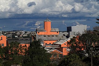
Chatswood is a suburb in the city of Auckland, New Zealand, in the middle-eastern side of North Shore. It contains a primary school and many parks. To the south of Chatswood is Kendall's Bay, a small bay of the Waitematā Harbour. The suburb is under the governance of Auckland Council. The Royal New Zealand Navy's Kauri Point Armament Depot is located in Chatswood. Chelsea Sugar Refinery is located in Chatswood.

<span class="mw-page-title-main">Castor Bay</span> Suburb in Auckland, New Zealand

Castor Bay is a bay and suburb of the North Shore, located in Auckland which is in the North Island of New Zealand. Located between Milford and Campbells Bay, it is part of the East Coast Bays. To the east lies the islands of Rangitoto and Motutapu, which are easily visible from land. The suburb is in the North Shore ward, one of the thirteen administrative divisions of Auckland Council.

<span class="mw-page-title-main">Rothesay Bay</span> Suburb in Auckland, New Zealand

Rothesay Bay is a small suburb in Auckland's East Coast Bays region. The suburb is roughly the same size as Murrays Bay, the suburb to the immediate south.

<span class="mw-page-title-main">Ōmaha</span> Locality in Auckland Region, New Zealand

Ōmaha is a small beach town on Ōmaha Bay in the Auckland Region, in the north of New Zealand. It is located 74.7 km north of central Auckland. It is on a sandspit that adjoins Tāwharanui Peninsula and separates Whangateau Harbour from Ōmaha Bay. The nearest sizable town is Warkworth which is situated 16.8 km south west of Ōmaha.

<span class="mw-page-title-main">Ōkura River</span> River in the Auckland Region, New Zealand

The Ōkura River, also known as the Ōkura Estuary, is a river in the north of the Auckland Region in the North Island of New Zealand. The river rises in the low hills to the south of Silverdale and flows into Karepiro Bay on the Hauraki Gulf / Tīkapa Moana. The river is extremely tidal with only a narrow channel being navigable by small craft at low tide. The area is popular for horse riding, riders wait till low tide and then ford the boating channel to ride the estuary and beaches on the northern side.

<span class="mw-page-title-main">Murrays Bay</span> Suburb in Auckland, New Zealand

Murrays Bay is a small suburb in the East Coast Bays region, located in the North Shore of Auckland. The suburb is roughly the same size as Rothesay Bay, the suburb to the immediate north. It is primarily a residential area but does have a community centre, restaurant and café. Murrays Bay is regularly serviced by buses which go to Takapuna and the Auckland city centre.

<i>Paphies australis</i> Species of bivalve

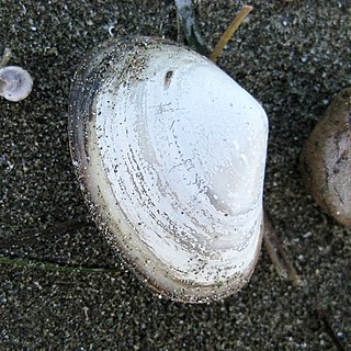
Paphies australis or pipi is a bivalve mollusc of the family Mesodesmatidae, endemic to New Zealand.

<span class="mw-page-title-main">Campbells Bay</span> Suburb in Auckland, New Zealand

Campbells Bay is a suburb of the North Shore located in Auckland, New Zealand. Centennial Park is a popular recreational space that has walking tracks and stunning harbour views.

<span class="mw-page-title-main">Cape Rodney-Okakari Point Marine Reserve</span>

Cape Rodney-Okakari Point Marine Reserve is a 5.5 km2 (2.1 sq mi) protected area in the North Island of New Zealand.

<span class="mw-page-title-main">Scandrett Regional Park</span> Public park in Auckland, New Zealand

Scandrett Regional Park is a regional park located on the north east tip of the Mahurangi Peninsula, north of the city of Auckland, New Zealand. It encompasses Mullet Point and includes regenerating coastal forest, rocky headlands that protrude into Kawau Bay, Scandretts Bay beach and a precinct of historic farm buildings. The people of Auckland own the park through the Auckland Council.

<span class="mw-page-title-main">Waiake</span> Suburb in Auckland, New Zealand

Waiake is one of the northernmost suburbs of the North Shore, in Auckland, New Zealand. It is located in the East Coast Bays between the suburbs of Browns Bay to the south and Torbay to the north. It has a beach, which looks out to the Tor, a presque-isle at the north end of the beach that becomes an island at high tide. Waiake is under the local governance of the Auckland Council.

<span class="mw-page-title-main">Schnapper Rock</span> Suburb in Auckland, New Zealand

Schnapper Rock is a western suburb on the North Shore of Auckland, New Zealand. The suburb is currently under local governance of Auckland Council. The area was known for a gum digging hut used by early European settlers in the mid-19th century. North Shore Memorial Park was opened area in 1974, and the area developed into suburban housing in the early 2000s.

<span class="mw-page-title-main">Big Muddy Creek (New Zealand)</span> River in the Auckland Region, New Zealand

The Big Muddy Creek is an estuarine tidal inlet of the Auckland Region of New Zealand's North Island. It flows south from its tributary rivers, the Nihotupu Stream and the Island stream in the Waitākere Ranges which are dammed at the Lower Nihotupu Reservoir, towards the Manukau Harbour.

<span class="mw-page-title-main">Lucas Creek</span> River in Auckland Region, New Zealand

Lucas Creek is a stream and tidal estuary of Upper Waitematā Harbour in the Auckland Region of New Zealand's North Island. It flows through Albany on the western North Shore, and enters the Upper Waitematā Harbour between Pāremoremo and Greenhithe.

References

  1. 1 2 3 4 5 6 7 8 9 Whangateau Catchment and Harbour Study: Review of Marine Environment Information (PDF) (Report). Auckland Regional Council. July 2009. ISBN   978-1-877528-10-1 . Retrieved 3 January 2023.
  2. Teas, H.J. (2013). Biology and ecology of mangroves. Springer Science & Business Media. ISBN   9789401709149.
  3. Ministry of Agriculture and Fisheries, Animal Health Division (2009). "Surveillance" (PDF). Surveillance. 36 (4).
  4. "Cockle beds still in perilous state". Rodney Times. 15 April 2014. Retrieved 21 January 2016.
  5. 1 2 3 4 5 Ngāti Manuhiri; The Crown (21 May 2011). Deed of Settlement Schedule: Documents (PDF) (Report). New Zealand Government . Retrieved 3 January 2023.
  6. 1 2 3 "History: Ngāti Manuhiri". Ngāti Manuhiri. Retrieved 3 January 2023.
  7. Rogers, Frank (1990). "Dacre, Ranulph". Dictionary of New Zealand Biography. Te Ara: The Encyclopedia of New Zealand . Retrieved 3 January 2023.