
The North Shore is one of the major geographical regions of Auckland, the largest city in New Zealand. The area is defined as the northern shores of the Waitematā Harbour as far north as the Ōkura River.

Browns Bay is one of the most northernmost suburbs in the contiguous Auckland metropolitan area, located in the North Shore. Named after the Brown family who settled here in 1876, Browns Bay became a holiday destination in the late 19th century. The area gradually developed into a suburb of Auckland in the 1950s, and was the administrative centre for the East Coast Bays City from 1975 until it was disestablished in 1989. During the 1990s, the suburb became a hub for the South African New Zealander community.
Torbay is a northern suburb of Auckland, New Zealand. It is located in the upper East Coast Bays of the city's North Shore, and is governed by Auckland Council.
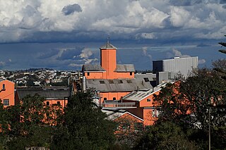
Chatswood is a suburb in the city of Auckland, New Zealand, in the middle-eastern side of North Shore. It contains a primary school and many parks. To the south of Chatswood is Kendall's Bay, a small bay of the Waitematā Harbour. The suburb is under the governance of Auckland Council. The Royal New Zealand Navy's Kauri Point Armament Depot is located in Chatswood. Chelsea Sugar Refinery is located in Chatswood.
Leigh is a small coastal community in the north of the Auckland Region of New Zealand. It lies on the west side of Omaha Cove, a small inlet within Ōmaha Bay to the south of Cape Rodney. It is 13 km from Matakana, 21 km from Warkworth and approximately 92 km north of Auckland City.
Mathesons Bay is a small beach in the Rodney district of the Auckland Region of New Zealand. It is 21 kilometres north-east of Warkworth, near the small community of Leigh. It comprises mainly holiday homes, with a small number of permanent residents.

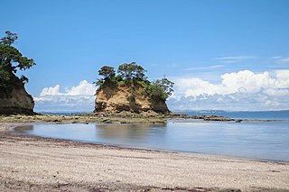
Ōmaha is a small beach town on Ōmaha Bay in the Auckland Region, in the north of New Zealand. It is located 74.7 km north of central Auckland. It is on a sandspit that adjoins Tāwharanui Peninsula and separates Whangateau Harbour from Ōmaha Bay. The nearest sizable town is Warkworth which is situated 16.8 km south west of Ōmaha.
Whangateau is a small town on the east coast of the North Island of New Zealand. It is situated in Rodney District, part of the Auckland Region, and is on a peninsula stretching out into the Hauraki Gulf, north of Auckland. Whangateau is on the northern shore of Whangateau Harbour which is fed by the Ōmaha River and separated from Ōmaha Bay by the Maungatawhiri sandspit. The settlement is in two parts of 20 to 30 houses each. The main settlement includes a large public reserve with sports fields and a campground. There is also a public hall which hosts music events and a flax weaving group. The smaller settlement is Tram Car Bay, named for two tram cars which were used as holiday homes. Whangateau is situated between the rural settlement of Matakana and the fishing village of Leigh. A tsunami siren is located in the town.
Murrays Bay is a small suburb in the East Coast Bays region, located in the North Shore of Auckland. The suburb is roughly the same size as Rothesay Bay, the suburb to the immediate north. It is primarily a residential area but does have a community centre, restaurant and café. Murrays Bay is regularly serviced by buses which go to Takapuna and the Auckland city centre.

Goat Island or Te Hāwere-a-Maki is a tiny island in New Zealand located close to the North Island coast, north of Auckland, northeast of Warkworth, and directly west of Little Barrier Island. It is within Cape Rodney-Okakari Point Marine Reserve, New Zealand's first marine reserve.

Long Bay is one of the northernmost suburbs of the North Shore, part of the contiguous Auckland metropolitan area located in New Zealand.
Campbells Bay is a suburb of the North Shore located in Auckland, New Zealand. Centennial Park is a popular recreational space that has walking tracks and stunning harbour views.

Cape Rodney-Okakari Point Marine Reserve is a 5.5 km2 (2.1 sq mi) protected area in the North Island of New Zealand.

The Leigh Marine Laboratory is the marine research facility for the University of Auckland in New Zealand. The laboratory is situated in north eastern New Zealand, 100 kilometres (62 mi) north of Auckland city. The facility is perched on the cliffs overlooking the Cape Rodney-Okakari Point Marine Reserve that covers 5 kilometres (3.1 mi) of coastline from Cape Rodney to Okakari Point.

Scandrett Regional Park is a regional park located on the north east tip of the Mahurangi Peninsula, north of the city of Auckland, New Zealand. It encompasses Mullet Point and includes regenerating coastal forest, rocky headlands that protrude into Kawau Bay, Scandretts Bay beach and a precinct of historic farm buildings. The people of Auckland own the park through the Auckland Council.

Tamaki Drive is the coastal road which follows the contours of the Waitematā Harbour, Auckland, New Zealand. The road links the suburbs Ōrākei, Mission Bay, and Kohimarama ending in Saint Heliers providing easy access to the local beaches. Tamaki Drive was completed in 1932 and incorporates The Strand, Bice Esplanade and, what was once part of the old Kohimarama Road. It is also referred to as the Waterfront Road. Tamaki Drive is a flat road around 8 km long and popular with walkers, runners and roller skaters, and includes a dedicated cycle lane. Those travelling along Tamaki Drive can find scenic highlights and peaceful views across the harbour to the volcanic island Rangitoto. The cliffs backing onto Tamaki Drive are made of Waitematā Sandstone strata clothed in places with pōhutukawa. These trees seem to flower out of season, because these are actually Kermadec pōhutukawa with small distinctive roundish leaves.

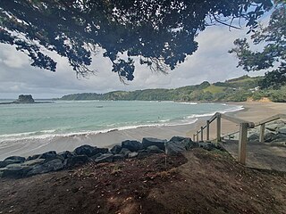
Waiake is one of the northernmost suburbs of the North Shore, in Auckland, New Zealand. It is located in the East Coast Bays between the suburbs of Browns Bay to the south and Torbay to the north. It has a beach, which looks out to the Tor, a presque-isle at the north end of the beach that becomes an island at high tide. Waiake is under the local governance of the Auckland Council.
Ngā Oho, also known as Ngā Ohomatakamokamo-o-Ohomairangi, is the name of a historical iwi (tribe) of Māori who settled in the Auckland Region. In the 17th century, Ngā Oho and two other tribes of shared heritage, Ngā Riki and Ngā Iwi, formed the Waiohua confederation of tribes.

The Whangateau Harbour is a natural harbour in New Zealand. It is a sandspit estuary, located on the north-eastern coast of the Auckland Region north-east of Matakana, and empties into the Hauraki Gulf. Due to the harbour's high quality water and dense shellfish beds, the harbour is a popular spot for shellfish gathering.

The Waiwera River is a stream of the Auckland Region of New Zealand's North Island, near the township of Waiwera.

