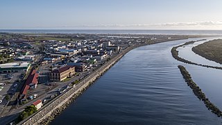
Sandspit is a settlement in the Auckland Region of New Zealand. It is on the Mahurangi Peninsula, about 65 kilometres north of the city centre. It has experienced substantial increases in property values during the first two decades of the 21st century.[3]
Ferries run several times a day from Sandspit to Kawau Island.[4] Ferry service between Sandspit and Kawau first started in 1934, with a boat which was (possibly later) called Nancibel[l].[5][6] In the 1950s, Nancibel was replaced by Mairie and Kawau Isle.[7]
Brick Bay, which is adjacent to Sandspit, has a sculpture trail along a two-kilometre path through native bush, fields and ponds.[8]
Demographics
Statistics New Zealand describes Sandspit as a rural settlement, which covers 3.46km2 (1.34sqmi)[1] and had an estimated population of 520 as of June 2024,[2] with a population density of 150 people per km2. Sandspit settlement is part of the larger Sandspit statistical area.
Sandspit settlement had a population of 522 in the 2023 New Zealand census, a decrease of 6 people (−1.1%) since the 2018 census, and an increase of 36 people (7.4%) since the 2013 census. There were 255 males and 264 females in 225 dwellings.[11] 2.9% of people identified as LGBTIQ+. The median age was 61.4 years (compared with 38.1 years nationally). There were 51 people (9.8%) aged under 15 years, 33 (6.3%) aged 15 to 29, 213 (40.8%) aged 30 to 64, and 225 (43.1%) aged 65 or older.[10]
People could identify as more than one ethnicity. The results were 94.8% European (Pākehā); 5.2% Māori; 1.7% Pasifika; 1.7% Asian; 0.6% Middle Eastern, Latin American and African New Zealanders (MELAA); and 3.4% other, which includes people giving their ethnicity as "New Zealander". English was spoken by 98.9%, Māori language by 1.1%, and other languages by 9.2%. No language could be spoken by 0.6% (e.g. too young to talk). The percentage of people born overseas was 30.5, compared with 28.8% nationally.
Religious affiliations were 31.6% Christian, 0.6% Hindu, and 0.6% other religions. People who answered that they had no religion were 58.6%, and 8.6% of people did not answer the census question.
Of those at least 15 years old, 111 (23.6%) people had a bachelor's or higher degree, 246 (52.2%) had a post-high school certificate or diploma, and 78 (16.6%) people exclusively held high school qualifications. The median income was $42,100, compared with $41,500 nationally. 78 people (16.6%) earned over $100,000 compared to 12.1% nationally. The employment status of those at least 15 was that 168 (35.7%) people were employed full-time, 84 (17.8%) were part-time, and 3 (0.6%) were unemployed.[10]
Sandspit statistical area
Sandspit statistical area, which includes the area between the settlement and Warkworth, covers 22.25km2 (8.59sqmi)[1] and had an estimated population of 1,010 as of June 2024,[12] with a population density of 45 people per km2.
View of Kawau Bay from SandspitView of Kawau Bay from Sandspit Wharf
Sandspit statistical area had a population of 990 in the 2023 New Zealand census, an increase of 21 people (2.2%) since the 2018 census, and an increase of 111 people (12.6%) since the 2013 census. There were 480 males and 507 females in 387 dwellings.[14] 2.4% of people identified as LGBTIQ+. The median age was 57.0 years (compared with 38.1 years nationally). There were 135 people (13.6%) aged under 15 years, 96 (9.7%) aged 15 to 29, 414 (41.8%) aged 30 to 64, and 342 (34.5%) aged 65 or older.[13]
People could identify as more than one ethnicity. The results were 94.5% European (Pākehā); 5.8% Māori; 2.4% Pasifika; 2.1% Asian; 0.6% Middle Eastern, Latin American and African New Zealanders (MELAA); and 4.2% other, which includes people giving their ethnicity as "New Zealander". English was spoken by 98.2%, Māori language by 0.6%, Samoan by 0.3%, and other languages by 10.0%. No language could be spoken by 0.9% (e.g. too young to talk). The percentage of people born overseas was 28.5, compared with 28.8% nationally.
Religious affiliations were 32.1% Christian, 0.3% Hindu, 0.3% Jewish, and 0.3% other religions. People who answered that they had no religion were 58.2%, and 8.2% of people did not answer the census question.
Of those at least 15 years old, 201 (23.5%) people had a bachelor's or higher degree, 441 (51.6%) had a post-high school certificate or diploma, and 156 (18.2%) people exclusively held high school qualifications. The median income was $43,600, compared with $41,500 nationally. 144 people (16.8%) earned over $100,000 compared to 12.1% nationally. The employment status of those at least 15 was that 339 (39.6%) people were employed full-time, 150 (17.5%) were part-time, and 9 (1.1%) were unemployed.[13]
Matamata-Piako District is a local government area in the Waikato region of New Zealand. It lies to the east of the city of Hamilton.
The South Wairarapa District is a district at the south-east tip of the North Island of New Zealand, governed by the South Wairarapa District Council. The district comprises the southernmost part of the Wairarapa, and is part of the Wellington Region.
The Thames-Coromandel District is a territorial authority district in the North Island of New Zealand, covering all the Coromandel Peninsula and extending south to Hikutaia.
Hauraki District is a territorial authority governed by the Hauraki District Council within the Waikato region of New Zealand. The seat of the council is at Paeroa.
Southland District is a New Zealand territorial authority district that covers most of the southern end of the South Island as well as Stewart Island.
Central Otago District is local government district in New Zealand. It is administered by the Central Otago District Council, and it is in the Otago region, the top tier of local government in New Zealand. The major towns in the district are Alexandra, Cromwell, Roxburgh, Clyde and Ranfurly. The district covers 9,968 km2 (3,849 sq mi), making it the fourth-largest district in New Zealand by area, and is home to 26,500 people as of June 2024.
Westland District is a territorial authority district on the West Coast of New Zealand's South Island. It is administered by the Westland District Council. The district's population is 9,430.
Buller District is one of 53 districts of New Zealand, and is within the West Coast Region. It covers Westport, Karamea, Reefton and Inangahua Junction.
Grey District is a district in the West Coast Region of New Zealand that covers Greymouth, Runanga, Blackball, Cobden, and settlements along the Grey River. It has a land area of 3,474.31 square kilometres (1,341.44 sq mi). The seat of the Grey District Council, the local government authority that administers the district, is at Greymouth, where 58.4% of the district's population live.
Clutha District is a local government district of southern New Zealand, with its headquarters in the Otago town of Balclutha. Clutha District has a land area of 6,334.47 km2 (2,445.75 sq mi) and an estimated population of 19,300 as of June 2024. Clutha District occupies the majority of the geographical area known as South Otago.
South Taranaki is a territorial authority on the west coast of New Zealand's North Island that contains the towns of Hāwera, Manaia, Ōpunake, Patea, Eltham, and Waverley. The District has a land area of 3,575.46 km2 and a population of 30,400. It is part of the greater Taranaki Region.
Mackenzie District is a local government district on New Zealand's South Island, administered by the Mackenzie District Council. It is part of the larger Canterbury Region. The region takes its name from the Mackenzie Basin, an elliptical intermontane basin which covers much of inland Canterbury.
Taupō District is a territorial authority district in New Zealand. It covers 6,333 km² of land, and a further 610 km² of lake area, including Lake Taupō, New Zealand's largest lake, and Lake Rotoaira. The district stretches from the small town of Mangakino in the northwest to the Tongariro National Park in the south, and east into the Kaingaroa Forest. The district's population is largely located in the two main centres, Taupō and Tūrangi.
Tikipunga is one of the biggest suburbs in Whangārei, New Zealand. It is in the north-east part of the city and has the landmark Whangārei Falls nearby.
Whangarei District is a territorial authority district in the Northland Region of New Zealand that is governed by the Whangarei District Council. The district is made up in area largely by rural land, and includes a fifth of the Northland Region. It extends southwards to the southern end of Bream Bay, northwards to Whangaruru and almost to the Bay of Islands, and westwards up the Mangakahia River valley past Pakotai and almost to Waipoua Forest. It includes the Hen and Chicken Islands and the Poor Knights Islands.
Ōtorohanga District is a territorial authority in the King Country area and Waikato region of the North Island of New Zealand. It is a mostly rural area, with Ōtorohanga town being by far the biggest urban area, with a population nearing 3,000. The District was called Otorohanga County from 1971 to 1979.
Wairoa District is a territorial authority district within the Hawke's Bay Region in the North Island of New Zealand. The Wairoa District Council is headquartered in the largest town, Wairoa. The district covers the northern half of the Hawke's Bay coast, extending from Māhia Peninsula to Lake Waikaremoana, and south to the mouth of the Waikare River.
Timaru District is a local government district on New Zealand's South Island, administered by the Timaru District Council. It is part of the larger Canterbury Region. Timaru district was formed in 1989 from the amalgamation of Timaru City, Geraldine borough, Temuka borough and Strathallan County.
Ashburton District is a territorial authority district in the Canterbury Region of the South Island of New Zealand. It encompasses the town of Ashburton, a number of small towns and settlements and the surrounding rural area, roughly coterminous with Mid Canterbury. The district had a population of 38,400 as of June 2024.
Waimate District is a territorial authority district located in the Canterbury Region of the South Island of New Zealand. The main town is Waimate, while there are many smaller rural communities dispersed throughout the area. Its boundary to the south is the Waitaki River, to the west Lake Benmore and to the north-east the Pareora River.
This page is based on this Wikipedia article Text is available under the CC BY-SA 4.0 license; additional terms may apply. Images, videos and audio are available under their respective licenses.