Rodney District was a local government area in the northernmost part of New Zealand's Auckland Region from 1989 to 2010. It included Kawau Island. It was created from the amalgamation of Helensville Borough and Rodney County in 1989. The seat of Rodney District Council was at Orewa. Rodney District and Rodney County each took their names from Cape Rodney, which Captain James Cook named on 24 November 1769 after Admiral Sir George Brydges Rodney.

Franklin District was a New Zealand territorial authority that lay between the Auckland metropolitan area and the Waikato Plains. As a formal territory, it was abolished on 31 October 2010 and divided between Auckland Council in the Auckland Region to the north and Waikato and Hauraki districts in the Waikato region to the south and east. The Auckland portion is now part of the Franklin Ward, which also includes rural parts of the former Manukau City.

Auckland is one of the 16 regions of New Zealand, which takes its name from the eponymous urban area. The region encompasses the Auckland metropolitan area, smaller towns, rural areas, and the islands of the Hauraki Gulf. Containing 33 percent of the nation's residents, it has by far the largest population and economy of any region of New Zealand, but the second-smallest land area.

Kaipara Harbour is a large enclosed harbour estuary complex on the north western side of the North Island of New Zealand. The northern part of the harbour is administered by the Kaipara District and the southern part is administered by the Auckland Council. The local Māori tribe is Ngāti Whātua.

Muriwai, also called Muriwai Beach, is a coastal community on the west coast of the Auckland Region in the North Island of New Zealand. The black-sand surf beach and surrounding area is a popular recreational area for Aucklanders. The Muriwai Regional Park includes a nesting site for a large colony of gannets.
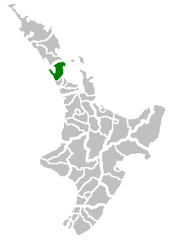
Kumeū is an affluent rural town and suburb of Auckland situated 25 km north-west of the City Centre in New Zealand. State Highway 16 and the North Auckland Line pass through the town. Huapai lies to the west, Riverhead to the north, Whenuapai to the east, and Taupaki to the south.
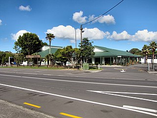
Helensville is a town in the North Island of New Zealand. It is sited 40 kilometres (25 mi) northwest of Auckland, close to the southern extremity of the Kaipara Harbour. State Highway 16 passes through the town, connecting it to Waimauku 16 kilometres (10 mi) to the south, and Kaukapakapa about 12 kilometres (7.5 mi) to the north-east. Parakai is two kilometres (1.2 mi) to the north-west.

The North Harbour Rugby Union (NHRU), commonly known as North Harbour or simply Harbour, is the governing body of rugby union that encompasses a wide geographical area north of Auckland that includes North Shore City, Rodney District, the Hibiscus Coast and part of Waitakere City. There are 12 rugby clubs from Mahurangi RFC, based in Warkworth, Rodney District, in the north through to Massey the southernmost area of the union.
Parakai is a town in the North Island of New Zealand, sited 43 kilometres northwest of Auckland, close to the southern extremity of the Kaipara Harbour. Helensville is about 3 km (1.9 mi) to the south-east, and Waioneke is 22 km (14 mi) to the north-west.

Huapai is a locality north-west of Auckland, New Zealand. State Highway 16 and the North Auckland Railway Line pass through it. Kumeū is adjacent to the east, Riverhead is to the north-east, and Waimauku to the west.
Waimauku is a small locality in the Auckland Region of New Zealand. It comes under the jurisdiction of Auckland Council, and is in the council's Rodney ward. Waimauku is approximately 4 kilometres west of Huapai on State Highway 16 at the junction with the road to Muriwai Beach. Helensville is 16 km to the north-west. Waimauku is a Māori word which is literally translated as wai: stream and mauku: varieties of small ferns.

Kaukapakapa is a town in the North Island of New Zealand. It is situated in the Rodney ward of the Auckland Region and is around 50 kilometres northwest of Auckland city. State Highway 16 passes through the town, connecting it to Helensville about 12 km to the south-west, and Araparera about 14 km to the north. The North Auckland Line also passes through Kaukapakapa. The Kaukapakapa River flows from the town to the Kaipara Harbour to the west.

Helensville was a New Zealand parliamentary electorate in the Auckland region, returning one Member of Parliament to the House of Representatives. The electorate was first established for the 1978 election, was abolished in 1984, and then reinstated for the 2002 election. The seat was won and held by John Key through his term as prime minister. Chris Penk of the National Party held the seat from the 2017 general election until its abolition in 2020, when it was replaced with the new Kaipara ki Mahurangi electorate, which Penk also retained.

Rodney was a New Zealand parliamentary electorate, returning one Member of Parliament to the House of Representatives. The last MP for Rodney was Mark Mitchell of the National Party. He held this position from 2011 until the electorate was replaced with Whangaparāoa in 2020. Mitchell stood for and won that seat.
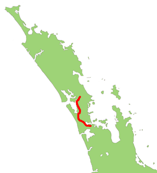
State Highway 16 is a New Zealand state highway linking central Auckland with Wellsford, via Auckland's Northwestern Motorway, Helensville and Kaukapakapa. It provides an alternative to SH 1 for traffic travelling between Auckland and parts of Northland from Wellsford northwards.

The Rodney Power Station was a proposal for a natural gas fired combined cycle power station developed by Genesis Energy Limited. The project was abandoned in 2015.

Rodney Ward is a local government area in the northernmost part of New Zealand's Auckland Region, created along with the Auckland Council in 2010. The area was previously part of Rodney District; it does not include the Hibiscus Coast, which was also part of Rodney District but is now in Albany ward. The Rodney Local Board area has the same boundaries as Rodney Ward.

Sir Gordon Charles Mason was a New Zealand local-body politician and businessman. He served as the mayor of Rodney District from 1989 to 1992.
Kaipara ki Mahurangi is an electorate to the New Zealand House of Representatives. It was created for the 2020 election.

West Auckland is one of the major geographical areas of Auckland, the largest city in New Zealand. Much of the area is dominated by the Waitākere Ranges, the eastern slopes of the Miocene era Waitākere volcano which was upraised from the ocean floor, and now one of the largest regional parks in New Zealand. The metropolitan area of West Auckland developed between the Waitākere Ranges to the west and the upper reaches of the Waitematā Harbour to the east. It covers areas such as Glen Eden, Henderson, Massey and New Lynn.
