
Ngāti Whātua is a Māori iwi (tribe) of the lower Northland Peninsula of New Zealand's North Island. It comprises a confederation of four hapū (subtribes) interconnected both by ancestry and by association over time: Te Uri-o-Hau, Te Roroa, Te Taoū, and Ngāti Whātua-o-Ōrākei. The four hapū can act together or separately as independent tribes.

Kaipara Harbour is a large enclosed harbour estuary complex on the north western side of the North Island of New Zealand. The northern part of the harbour is administered by the Kaipara District and the southern part is administered by the Auckland Council. The local Māori tribe is Ngāti Whātua.

Muriwai, also called Muriwai Beach, is a coastal community on the west coast of the Auckland Region in the North Island of New Zealand. The black-sand surf beach and surrounding area is a popular recreational area for Aucklanders. The Muriwai Regional Park includes a nesting site for a large colony of gannets.
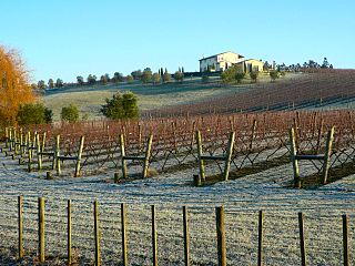
Kumeū is an affluent rural town and suburb of Auckland situated 25 km north-west of the City Centre in New Zealand. State Highway 16 and the North Auckland Line pass through the town. Huapai lies to the west, Riverhead to the north, Whenuapai to the east, and Taupaki to the south.
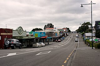
Helensville is a town in the North Island of New Zealand. It is sited 40 kilometres (25 mi) northwest of Auckland, close to the southern extremity of the Kaipara Harbour. State Highway 16 passes through the town, connecting it to Waimauku 16 kilometres (10 mi) to the south, and Kaukapakapa about 12 kilometres (7.5 mi) to the north-east. Parakai is two kilometres (1.2 mi) to the north-west.
The battle of Moremonui was fought between Ngāti Whātua and Ngāpuhi, two Māori iwi (tribes), in northern New Zealand in either 1807 or 1808. The Ngāpuhi force had a few muskets, making this the first occasion Māori used muskets in warfare. The Ngāti Whātua force ambushed the Ngāpuhi, and won the battle, which occurred at Moremonui Gully where it enters Ripiro Beach, 19 kilometres south of Maunganui Bluff on the west coast of Northland. It could reasonably be called the first battle of the Musket Wars between Māori, which took place over the next few decades.
Kaihu is a locality and settlement in Northland, New Zealand. The Kaihu River runs through the Kaihu Valley into the Wairoa River near Dargaville, approximately 32 km south east. State Highway 12 runs along the valley and passes through Kaihu settlement. Aranga is about 10 km north west. The Kaihu Forest is to the east and the Marlborough Forest is to the north.
Mangawhai is a locality in Northland, New Zealand around the Mangawhai Harbour. The township of Mangawhai is at the south west extent of the harbour, and the township of Mangawhai Heads is 5 km north east. Kaiwaka is 13 km south west, and Waipu is 20 km north west of Mangawhai Heads.

The Mangawhai Harbour is a natural harbour in New Zealand. It is a sandspit estuary, located on in the south-eastern coast of the Northland Region. The townships of Mangawhai and Mangawhai Heads are found on the harbour, as well as the Mangawhai Government Purpose Wildlife Refuge Reserve on the sandspit at the mouth of the harbour.

The Pouto Peninsula is a landform on the northern Kaipara Harbour in Northland, New Zealand. The Peninsula runs in the north west to south east direction and is approximately 55 km long. The width varies from about 5.4 km to about 14 km, with the widest part of the peninsula near its southern end. The Tasman Sea is to the west, and the Kaipara Harbour is to the south. The Wairoa River and Kaipara Harbour are to the east. Dargaville and State Highway 12 lie directly to the north east of the peninsula. The mouth of the Kaipara Harbour separates the peninsula from the smaller Te Korowai-o-Te-Tonga Peninsula to the south.

Te Roroa is a Māori iwi from the region between the Kaipara Harbour and the Hokianga Harbour in Northland, New Zealand. They are part of the Ngāti Whātua confederation of tribes.

Te Uri-o-Hau is a Māori iwi (tribe) based around New Zealand's Kaipara Harbour. It is both an independent iwi and a hapū (sub-tribe) of the larger Ngāti Whātua iwi, alongside Ngāti Whātua-o-Ōrākei, Te Roroa and Te Taoū. Its rohe includes Dargaville, Maungaturoto, Mangawhai, Kaiwaka and Wellsford.

Lake Rototoa is located at the northern end of the south head of the Kaipara Harbour in the Rodney ward of the Auckland Region, New Zealand. With a surface area of 1.39 km2 and a maximum depth of 26 m, it is the largest and deepest of a series of sand-dune lakes found along the western coastline of the North Island.

New Zealand has 15,000 kilometres (9,300 mi) of coastline making it the 9th longest in the world. The coastline borders the Tasman Sea and the Pacific Ocean. The northern and southernmost points of the coastline on the two main islands are Surville Cliffs and Slope Point respectively.

Lake Waitamoumou is a small dune-dammed lake a kilometre north of Raglan in the Waikato region of New Zealand.

Ngāti Whātua Ōrākei or Ngāti Whātua-o-Ōrākei is an Auckland-based Māori hapū (sub-tribe) in New Zealand. Together with Te Uri-o-Hau, Te Roroa and Te Taoū, it comprises the iwi (tribe) of Ngāti Whātua. These four hapū can act together or separately as independent tribes. The hapū's rohe is mostly in Tāmaki Makaurau, the site of present-day Auckland. Ngāti Whātua Ōrākei has around 6,000 members whose collective affairs are managed by the Ngāti Whātua Ōrākei Trust.

Tāmaki Māori are Māori iwi and hapū who have a strong connection to Tāmaki Makaurau, and whose rohe was traditionally within the region. Among Ngā Mana Whenua o Tāmaki Makaurau, also known as the Tāmaki Collective, there are thirteen iwi and hapū, organised into three rōpū (collectives), however Tāmaki Māori can also refer to subtribes and historical iwi not included in this list.

Te Korowai-o-Te-Tonga Peninsula, also known as South Head and by its former name of the South Kaipara Peninsula, is a long peninsula in the North Island of New Zealand, extending north along the western edge of the Kaipara Harbour for some 35 kilometres (22 mi) from near Helensville to the harbour's mouth. The peninsula was officially renamed in 2013 as part of a Treaty of Waitangi settlement. The name, which is Māori for "The cloak of the south", reflects the peninsula's geographical role in guarding the southern half of the Kaipara Harbour from the Tasman Sea and prevailing westerly winds. The mouth of the Kaipara Harbour separates the peninsula from the larger Pouto Peninsula to the north.

Whitireia Park is a headland north of Titahi Bay and Te Awarua-o-Porirua Harbour in Porirua, in the Wellington Region at the southern end of New Zealand's North Island. It is a regional park administered by Wellington Regional Council.

Te Ārai Regional Park is a regional park situated in the Auckland Region of New Zealand's North Island. It is owned and operated by Auckland Council.

